Map of Columbia County - Columbia County is a county located in the U.S. state of Washington. Columbia County Map showing cities, highways, important places and water bodies. Get Where is Columbia County located in the map, major cities in Columbia county, population, areas, and places of interest.
Map of Columbia County, Washington
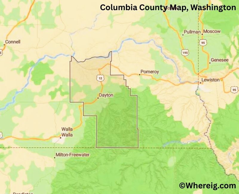
About Columbia County Map, Alabama: The map showing the county boundary, county seat, major cities, highways, water bodies and neighbouring counties.
Most Viewed Links
About Columbia County, Washington
Columbia County is located in the southeastern part of Washington, United States. Established in 1875, the county was named after the Columbia River, which flows through the Pacific Northwest region. The county seat and largest city is Dayton, which serves as the administrative and economic center of this largely rural county.
Population
According to the United States Census Bureau, the population of Columbia County was 3,952 as recorded in the 2020 Census. It is one of the least populous counties in Washington, with a strong agricultural base and small, close-knit communities.
Area and Geography
According to the United States Census Bureau, Columbia County covers a total area of approximately 873 square miles, including about 868 square miles of land and 5 square miles of water. The county is characterized by rolling wheat fields, river valleys, and rural landscapes typical of southeastern Washington.
Bordering Counties
Columbia County shares borders with Garfield County to the north, Walla Walla County to the south, and Asotin County to the east. The county also borders the state of Oregon to the south.
Major Cities and Communities
The primary incorporated city in Columbia County is Dayton, which serves as the county seat. Other small communities and rural areas support the county’s agricultural economy.
Attractions and Recreation
Columbia County offers outdoor recreation opportunities including hiking, fishing, and camping in its river valleys and scenic countryside. The Tucannon River area is known for fishing and wildlife viewing, while historic downtown Dayton reflects the county’s heritage and early settlement history.
Transportation
Major transportation routes serving Columbia County include U.S. Route 12 and State Route 261, connecting the county to neighboring communities and other parts of Washington.
Explore more counties in Washington Counties or view the complete USA States Map section for additional geographic information.
Sources:
Population and area data sourced from the United States Census Bureau (2020 Census). General county information referenced from the Official Columbia County Government Website.
Facts about Columbia County, Washington
| Country | United States |
| State | Washington |
| Region | Southeastern Washington |
| County Seat | Dayton |
| Named After | Columbia River |
| Established | 1875 |
| Organized | 1875 |
| Coordinates | 46.2940° N, 117.9100° W |
| Total Area | 873 sq mi |
| Land Area | 868 sq mi |
| Water Area | 5 sq mi |
| Population (2020) | 4,064 |
| Population Rank | Least populous county in Washington |
| Largest City | Dayton |
| Main Industries | Agriculture, Farming, Ranching |
| Major Highways | U.S. Route 12 |
| Time Zone | Pacific Time (UTC−08:00) |
| Known For | Wheat farming, Blue Mountains foothills, Rural landscapes |
| Website | https://www.columbiaco.com |
Top Attractions in Columbia County, Washington
- Palouse Falls State Park (nearby) – Dramatic waterfall views.
- Tucannon River – Fishing and scenic river valley.
- Tucannon River State Park – Camping and hiking.
- Blue Mountains – Mountain scenery and trails.
- Dayton Historic District – Shops and 19th-century buildings.
- Columbia County Historical Society Museum – Local history exhibits.
- Smith Hollow Country Schoolhouse – Preserved historic school.
- Dayton Depot – Historic railroad depot.
- Lyons Ferry State Park (nearby) – Snake River recreation.
- Patit Creek – Fishing and rural scenery.
- Waitsburg Historic Area (nearby) – Small-town charm.
- Columbia Plateau Farmlands – Rolling agricultural landscapes.
Cities & Towns in Columbia County, Washington
Dayton, Starbuck, Pomeroy, Waitsburg, Prescott, Tucannon, Kahlotus, Columbia County Rural Communities
- Adams County Map, WA
- Asotin County Map, WA
- Benton County Map, WA
- Chelan County Map, WA
- Clallam County Map, WA
- Clark County Map, WA
- Columbia County Map, WA
- Cowlitz County Map, WA
- Douglas County Map, WA
- Ferry County Map, WA
- Franklin County Map, WA
- Garfield County Map, WA
- Grant County Map, WA
- Grays Harbor County Map, WA
- Island County Map, WA
- Jefferson County Map, WA
- King County Map, WA
- Kitsap County Map, WA
- Kittitas County Map, WA
- Klickitat County Map, WA
- Lewis County Map, WA
- Lincoln County Map, WA
- Mason County Map, WA
- Okanogan County Map, WA
- Pacific County Map, WA
- Pend Oreille County Map, WA
- Pierce County Map, WA
- San Juan County Map, WA
- Skagit County Map, WA
- Skamania County Map, WA
- Snohomish County Map, WA
- Spokane County Map, WA
- Stevens County Map, WA
- Thurston County Map, WA
- Wahkiakum County Map, WA
- Walla Walla County Map, WA
- Whatcom County Map, WA
- Whitman County Map, WA
- Yakima County Map, WA
- Alabama Counties
- Alaska boroughs
- Arizona Counties
- Arkansas Counties
- California County Map
- Colorado Counties
- Connecticut Counties
- Delaware Counties
- Florida County Map
- Georgia County Map
- Hawaii Counties
- Idaho Counties
- Illinois Counties
- Indiana Counties
- Iowa Counties
- Kansas Counties
- Kentucky Counties
- Louisiana Counties
- Maine Counties
- Maryland Counties
- Massachusetts Counties
- Michigan County Map
- Minnesota Counties
- Mississippi Counties
- Missouri Counties
- Montana Counties
- Nebraska Counties
- Nevada Counties
- New York Counties
- New Hampshire Counties
- New Jersey Counties
- New Mexico Counties
- North Carolina Counties
- North Dakota Counties
- Ohio County Map
- Oklahoma Counties
- Oregon Counties
- Pennsylvania Counties
- Rhode Island Counties
- South Carolina Counties
- South Dakota Counties
- Map of Tennessee
- Texas County Map
- Utah Counties
- Vermont Counties
- Virginia Counties
- Washington Counties
- West Virginia Counties
- Wisconsin Counties
- Wyoming Counties