Map of Asotin County - Asotin County is a county located in the U.S. state of Washington. Asotin County Map showing cities, highways, important places and water bodies. Get Where is Asotin County located in the map, major cities in Asotin county, population, areas, and places of interest.
Map of Asotin County, Washington
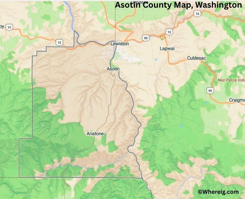
About Asotin County Map, Alabama: The map showing the county boundary, county seat, major cities, highways, water bodies and neighbouring counties.
Most Viewed Links
About Asotin County, Washington
Asotin County is located in the southeastern part of Washington along the border with Idaho. Established in 1883, the county was formed from Garfield County and is named after a Nez Perce word meaning "eel creek." The county seat is Asotin, while Clarkston is the largest city and serves as the primary commercial center of the county.
Population
According to the United States Census Bureau, the population of Asotin County was 22,285 as recorded in the 2020 Census. The county has a relatively small population compared to many other counties in Washington, with most residents living in Clarkston and nearby communities.
Area and Geography
According to the United States Census Bureau, Asotin County covers a total area of approximately 641 square miles, including about 636 square miles of land and 4.4 square miles of water. The landscape includes rolling hills, river valleys, and portions of the Snake River, which forms part of the boundary with Idaho.
Bordering Counties
Asotin County shares borders with Garfield County to the northwest and Columbia County to the west, while its eastern and southern boundaries meet the state of Idaho.
Major Cities and Communities
The incorporated communities in Asotin County include Clarkston and Asotin. Clarkston serves as the economic hub of the county and is located directly across the Snake River from Lewiston, Idaho.
Attractions and Recreation
The Snake River is one of the county’s most significant natural features and supports boating, fishing, and outdoor recreation. Scenic canyon landscapes and nearby outdoor areas attract visitors throughout the year, offering opportunities for hiking, camping, and river activities in southeastern Washington.
Transportation
Major transportation routes in Asotin County include U.S. Route 12 and Washington State Route 129, which connect the county to other parts of Washington and neighboring Idaho.
Explore more counties in Washington Counties or view the complete USA States Map section for additional geographic information.
Sources:
Population and area data sourced from the United States Census Bureau (2020 Census). General county information referenced from the Official Asotin County Government Website.
Facts about Asotin County, Washington
| Country | United States |
| State | Washington |
| Region | Southeastern Washington |
| County Seat | Asotin |
| Named After | Asotin Creek (derived from a Nez Perce word meaning “eel creek”) |
| Established | 1883 |
| Organized | 1883 |
| Coordinates | 46.1880° N, 117.2030° W |
| Total Area | 641 sq mi |
| Land Area | 636 sq mi |
| Water Area | 5 sq mi |
| Population (2020) | 22,285 |
| Population Rank | One of the least populous counties in Washington |
| Largest City | Clarkston |
| Main Industries | Agriculture, Healthcare, Retail, Education |
| Major Highways | U.S. Route 12, State Route 129 |
| Time Zone | Pacific Time (UTC−08:00) |
| Known For | Snake River, Hells Canyon access, Scenic canyons |
| Website | https://www.co.asotin.wa.us |
Top Attractions in Asotin County, Washington
- Hells Gate State Park – Snake River views and recreation.
- Hells Canyon National Recreation Area – Deep canyon scenery.
- Snake River – Boating, fishing, and rafting.
- Asotin Creek Wildlife Area – Trails and wildlife viewing.
- Chief Timothy State Park (nearby) – River island park.
- Blue Mountains Scenic Area – Hiking and forest views.
- Clarkston Riverfront – Walking paths and river access.
- Asotin County Historical Society Museum – Local history exhibits.
- Umatilla National Forest (nearby) – Forest recreation.
- Grande Ronde River (nearby) – Scenic river canyon.
- Asotin Creek Canyon – Scenic drive and fishing.
- Clarkston Downtown – Shops and dining.
Cities & Towns in Asotin County, Washington
Asotin, Clarkston, Anatone, Asotin County Rural Communities
- Adams County Map, WA
- Asotin County Map, WA
- Benton County Map, WA
- Chelan County Map, WA
- Clallam County Map, WA
- Clark County Map, WA
- Columbia County Map, WA
- Cowlitz County Map, WA
- Douglas County Map, WA
- Ferry County Map, WA
- Franklin County Map, WA
- Garfield County Map, WA
- Grant County Map, WA
- Grays Harbor County Map, WA
- Island County Map, WA
- Jefferson County Map, WA
- King County Map, WA
- Kitsap County Map, WA
- Kittitas County Map, WA
- Klickitat County Map, WA
- Lewis County Map, WA
- Lincoln County Map, WA
- Mason County Map, WA
- Okanogan County Map, WA
- Pacific County Map, WA
- Pend Oreille County Map, WA
- Pierce County Map, WA
- San Juan County Map, WA
- Skagit County Map, WA
- Skamania County Map, WA
- Snohomish County Map, WA
- Spokane County Map, WA
- Stevens County Map, WA
- Thurston County Map, WA
- Wahkiakum County Map, WA
- Walla Walla County Map, WA
- Whatcom County Map, WA
- Whitman County Map, WA
- Yakima County Map, WA
- Alabama Counties
- Alaska boroughs
- Arizona Counties
- Arkansas Counties
- California County Map
- Colorado Counties
- Connecticut Counties
- Delaware Counties
- Florida County Map
- Georgia County Map
- Hawaii Counties
- Idaho Counties
- Illinois Counties
- Indiana Counties
- Iowa Counties
- Kansas Counties
- Kentucky Counties
- Louisiana Counties
- Maine Counties
- Maryland Counties
- Massachusetts Counties
- Michigan County Map
- Minnesota Counties
- Mississippi Counties
- Missouri Counties
- Montana Counties
- Nebraska Counties
- Nevada Counties
- New York Counties
- New Hampshire Counties
- New Jersey Counties
- New Mexico Counties
- North Carolina Counties
- North Dakota Counties
- Ohio County Map
- Oklahoma Counties
- Oregon Counties
- Pennsylvania Counties
- Rhode Island Counties
- South Carolina Counties
- South Dakota Counties
- Map of Tennessee
- Texas County Map
- Utah Counties
- Vermont Counties
- Virginia Counties
- Washington Counties
- West Virginia Counties
- Wisconsin Counties
- Wyoming Counties