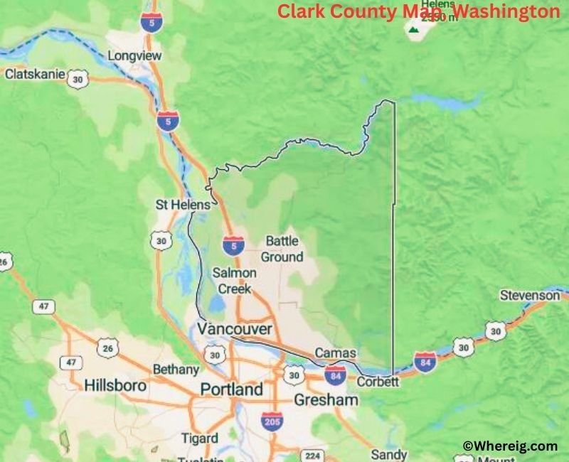
Map of Clark County - Clark County is a county located in the U.S. state of Washington. Clark County Map showing cities, highways, important places and water bodies. Get Where is Clark County located in the map, major cities in Clark county, population, areas, and places of interest.
Map of Clark County, Washington
About Clark County Map, Alabama: The map showing the county boundary, county seat, major cities, highways, water bodies and neighbouring counties.
Most Viewed Links
About Clark County, Washington
Clark County is located in the southwestern part of Washington, United States, along the Columbia River opposite the city of Portland in Oregon. Established in 1845, the county was named after William Clark of the Lewis and Clark Expedition. The county seat and largest city is Vancouver, which serves as a major urban and economic center in the Portland metropolitan area.
Population
According to the United States Census Bureau, the population of Clark County was 503,311 as recorded in the 2020 Census. It is one of the most populous counties in Washington and has experienced significant growth due to its proximity to Portland and strong regional economy.
Area and Geography
According to the United States Census Bureau, Clark County covers a total area of approximately 656 square miles, including about 629 square miles of land and 27 square miles of water. The Columbia River forms the county’s southern boundary, and the landscape includes river valleys, forests, and foothills leading toward the Cascade Range.
Bordering Counties
Clark County shares borders with Cowlitz County to the north, Skamania County to the east, and Lewis County to the northwest. Its southern boundary meets the state of Oregon across the Columbia River.
Major Cities and Communities
The principal cities in Clark County include Vancouver, Camas, Washougal, Battle Ground, and Ridgefield. Vancouver is the largest city and serves as the county seat, while Camas and Washougal are known for their riverfront settings and growing residential communities.
Attractions and Recreation
Clark County offers a variety of pa
Facts about Clark County, Washington
| Country | United States |
| State | Washington |
| Region | Southwestern Washington |
| County Seat | Vancouver |
| Named After | William Clark (of the Lewis and Clark Expedition) |
| Established | 1845 |
| Organized | 1845 |
| Coordinates | 45.7800° N, 122.4800° W |
| Total Area | 656 sq mi |
| Land Area | 629 sq mi |
| Water Area | 27 sq mi |
| Population (2020) | 503,311 |
| Population Rank | Fifth most populous county in Washington |
| Largest City | Vancouver |
| Main Industries | Manufacturing, Technology, Healthcare, Retail, Logistics |
| Major Highways | Interstate 5, Interstate 205, State Route 14 |
| Time Zone | Pacific Time (UTC−08:00) |
| Known For | Columbia River, Vancouver waterfront, Portland metro area |
| Website | https://clark.wa.gov |
Top Attractions in Clark County, Washington
- Fort Vancouver National Historic Site – Historic fur trading post.
- Vancouver Waterfront Park – Riverfront walks and views.
- Columbia River – Boating and scenic recreation.
- Esther Short Park – Downtown park and events.
- Mount St. Helens (nearby) – Volcanic landscapes.
- Ridgefield National Wildlife Refuge – Wetlands and birdwatching.
- Clark County Historical Museum – Regional history exhibits.
- Salmon Creek Greenway – Trails and nature.
- Officers Row – Historic military homes.
- Lacamas Lake Regional Park – Lake trails and waterfalls.
- Vancouver Barracks – Military history site.
- Frenchman’s Bar Regional Park – Beach and river views.
Cities & Towns in Clark County, Washington
Vancouver, Camas, Battle Ground, Washougal, Ridgefield, La Center, Yacolt, Felida, Salmon Creek, Hockinson
- Adams County Map, WA
- Asotin County Map, WA
- Benton County Map, WA
- Chelan County Map, WA
- Clallam County Map, WA
- Clark County Map, WA
- Columbia County Map, WA
- Cowlitz County Map, WA
- Douglas County Map, WA
- Ferry County Map, WA
- Franklin County Map, WA
- Garfield County Map, WA
- Grant County Map, WA
- Grays Harbor County Map, WA
- Island County Map, WA
- Jefferson County Map, WA
- King County Map, WA
- Kitsap County Map, WA
- Kittitas County Map, WA
- Klickitat County Map, WA
- Lewis County Map, WA
- Lincoln County Map, WA
- Mason County Map, WA
- Okanogan County Map, WA
- Pacific County Map, WA
- Pend Oreille County Map, WA
- Pierce County Map, WA
- San Juan County Map, WA
- Skagit County Map, WA
- Skamania County Map, WA
- Snohomish County Map, WA
- Spokane County Map, WA
- Stevens County Map, WA
- Thurston County Map, WA
- Wahkiakum County Map, WA
- Walla Walla County Map, WA
- Whatcom County Map, WA
- Whitman County Map, WA
- Yakima County Map, WA
- Alabama Counties
- Alaska boroughs
- Arizona Counties
- Arkansas Counties
- California County Map
- Colorado Counties
- Connecticut Counties
- Delaware Counties
- Florida County Map
- Georgia County Map
- Hawaii Counties
- Idaho Counties
- Illinois Counties
- Indiana Counties
- Iowa Counties
- Kansas Counties
- Kentucky Counties
- Louisiana Counties
- Maine Counties
- Maryland Counties
- Massachusetts Counties
- Michigan County Map
- Minnesota Counties
- Mississippi Counties
- Missouri Counties
- Montana Counties
- Nebraska Counties
- Nevada Counties
- New York Counties
- New Hampshire Counties
- New Jersey Counties
- New Mexico Counties
- North Carolina Counties
- North Dakota Counties
- Ohio County Map
- Oklahoma Counties
- Oregon Counties
- Pennsylvania Counties
- Rhode Island Counties
- South Carolina Counties
- South Dakota Counties
- Map of Tennessee
- Texas County Map
- Utah Counties
- Vermont Counties
- Virginia Counties
- Washington Counties
- West Virginia Counties
- Wisconsin Counties
- Wyoming Counties