Map of Ferry County - Ferry County is a county located in the U.S. state of Washington. Ferry County Map showing cities, highways, important places and water bodies. Get Where is Ferry County located in the map, major cities in Ferry county, population, areas, and places of interest.
Map of Ferry County, Washington
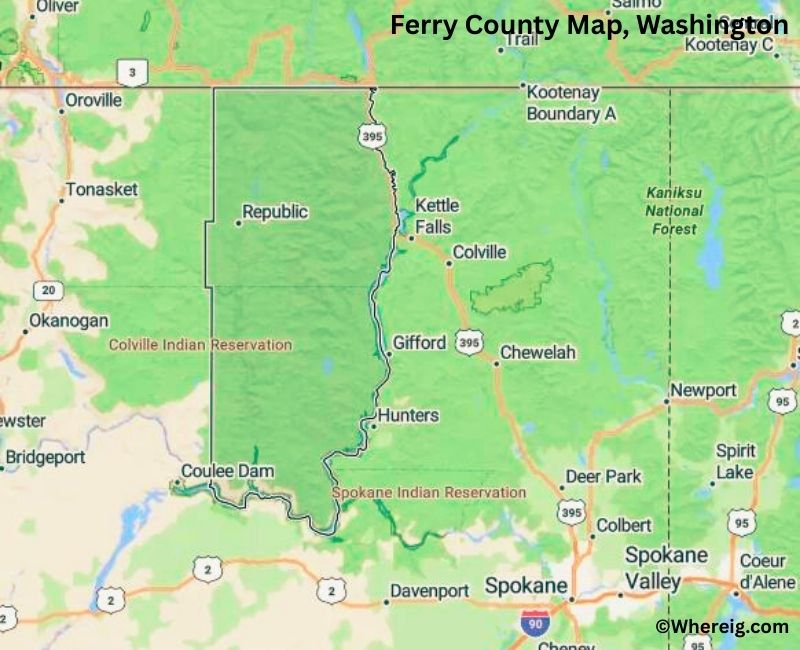
About Ferry County Map, Alabama: The map showing the county boundary, county seat, major cities, highways, water bodies and neighbouring counties.
Most Viewed Links
About Ferry County, Washington
Ferry County is located in the northeastern part of Washington, United States, along the border with Canada. Established in 1899, the county was named after Elisha P. Ferry, the first governor of Washington State. The county seat and largest city is Republic, which serves as the administrative and economic center of this rural county.
Population
According to the United States Census Bureau, the population of Ferry County was 7,178 as recorded in the 2020 Census. It is one of the least populous counties in Washington, with small communities spread across forested and mountainous terrain.
Area and Geography
According to the United States Census Bureau, Ferry County covers a total area of approximately 2,257 square miles, including about 2,204 square miles of land and 53 square miles of water. The county features mountains, forests, and river valleys, with large portions of land designated for natural resource management and recreation.
Bordering Counties
Ferry County shares borders with Okanogan County to the west and Stevens County to the east, while its northern boundary meets Canada.
Major Cities and Communities
The primary incorporated city in Ferry County is Republic, which serves as the county seat. Other small communities contribute to the county’s rural character and local economy.
Attractions and Recreation
Ferry County offers outdoor recreation opportunities including hiking, fishing, hunting, and camping in its forested landscapes. Curlew Lake State Park and surrounding wilderness areas attract visitors seeking scenic views and water-based activities.
Transportation
Major transportation routes serving Ferry County include State Route 20 and State Route 21, providing connections to neighboring counties and regional communities.
Explore more counties in Washington Counties or view the complete USA States Map section for additional geographic information.
Sources:
Population and area data sourced from the United States Census Bureau (2020 Census). General county information referenced from the Official Ferry County Government Website.
Facts about Ferry County, Washington
| Country | United States |
| State | Washington |
| Region | Northeastern Washington |
| County Seat | Republic |
| Named After | Elisha P. Ferry (first Governor of Washington) |
| Established | 1899 |
| Organized | 1899 |
| Coordinates | 48.4690° N, 118.5160° W |
| Total Area | 2,257 sq mi |
| Land Area | 2,203 sq mi |
| Water Area | 54 sq mi |
| Population (2020) | 7,178 |
| Population Rank | One of the least populous counties in Washington |
| Largest City | Republic |
| Main Industries | Forestry, Mining, Tourism, Agriculture |
| Major Highways | State Route 20, State Route 21 |
| Time Zone | Pacific Time (UTC−08:00) |
| Known For | Colville National Forest, Gold mining history, Scenic mountains |
| Website | https://www.ferry-county.com |
Top Attractions in Ferry County, Washington
- Republic Historic District – Shops and small-town history.
- Stonerose Interpretive Center – Fossil beds and exhibits.
- Curlew Lake State Park – Fishing and lakeside recreation.
- Kettle River – Scenic river and fishing.
- Kettle Crest Scenic Highway – Mountain views and forest drives.
- Sherman Pass Scenic Byway – Highest paved pass in Washington.
- Colville National Forest – Hiking and wilderness recreation.
- Ferry County Rail Trail – Walking and biking path.
- Ferry County Historical Society Museum – Local history exhibits.
- Curlew Lake – Boating and wildlife viewing.
- Toroda Creek Area – Scenic countryside and trails.
- Republic Brewing Company – Local craft brews.
Cities & Towns in Ferry County, Washington
Republic, Curlew, Inchelium, Keller, Orient, Danville, Ferry County Rural Communities
- Adams County Map, WA
- Asotin County Map, WA
- Benton County Map, WA
- Chelan County Map, WA
- Clallam County Map, WA
- Clark County Map, WA
- Columbia County Map, WA
- Cowlitz County Map, WA
- Douglas County Map, WA
- Ferry County Map, WA
- Franklin County Map, WA
- Garfield County Map, WA
- Grant County Map, WA
- Grays Harbor County Map, WA
- Island County Map, WA
- Jefferson County Map, WA
- King County Map, WA
- Kitsap County Map, WA
- Kittitas County Map, WA
- Klickitat County Map, WA
- Lewis County Map, WA
- Lincoln County Map, WA
- Mason County Map, WA
- Okanogan County Map, WA
- Pacific County Map, WA
- Pend Oreille County Map, WA
- Pierce County Map, WA
- San Juan County Map, WA
- Skagit County Map, WA
- Skamania County Map, WA
- Snohomish County Map, WA
- Spokane County Map, WA
- Stevens County Map, WA
- Thurston County Map, WA
- Wahkiakum County Map, WA
- Walla Walla County Map, WA
- Whatcom County Map, WA
- Whitman County Map, WA
- Yakima County Map, WA
- Alabama Counties
- Alaska boroughs
- Arizona Counties
- Arkansas Counties
- California County Map
- Colorado Counties
- Connecticut Counties
- Delaware Counties
- Florida County Map
- Georgia County Map
- Hawaii Counties
- Idaho Counties
- Illinois Counties
- Indiana Counties
- Iowa Counties
- Kansas Counties
- Kentucky Counties
- Louisiana Counties
- Maine Counties
- Maryland Counties
- Massachusetts Counties
- Michigan County Map
- Minnesota Counties
- Mississippi Counties
- Missouri Counties
- Montana Counties
- Nebraska Counties
- Nevada Counties
- New York Counties
- New Hampshire Counties
- New Jersey Counties
- New Mexico Counties
- North Carolina Counties
- North Dakota Counties
- Ohio County Map
- Oklahoma Counties
- Oregon Counties
- Pennsylvania Counties
- Rhode Island Counties
- South Carolina Counties
- South Dakota Counties
- Map of Tennessee
- Texas County Map
- Utah Counties
- Vermont Counties
- Virginia Counties
- Washington Counties
- West Virginia Counties
- Wisconsin Counties
- Wyoming Counties