Map of Yakima County - Yakima County is a county located in the U.S. state of Washington. Yakima County Map showing cities, highways, important places and water bodies. Get Where is Yakima County located in the map, major cities in Yakima county, population, areas, and places of interest.
Map of Yakima County, Washington
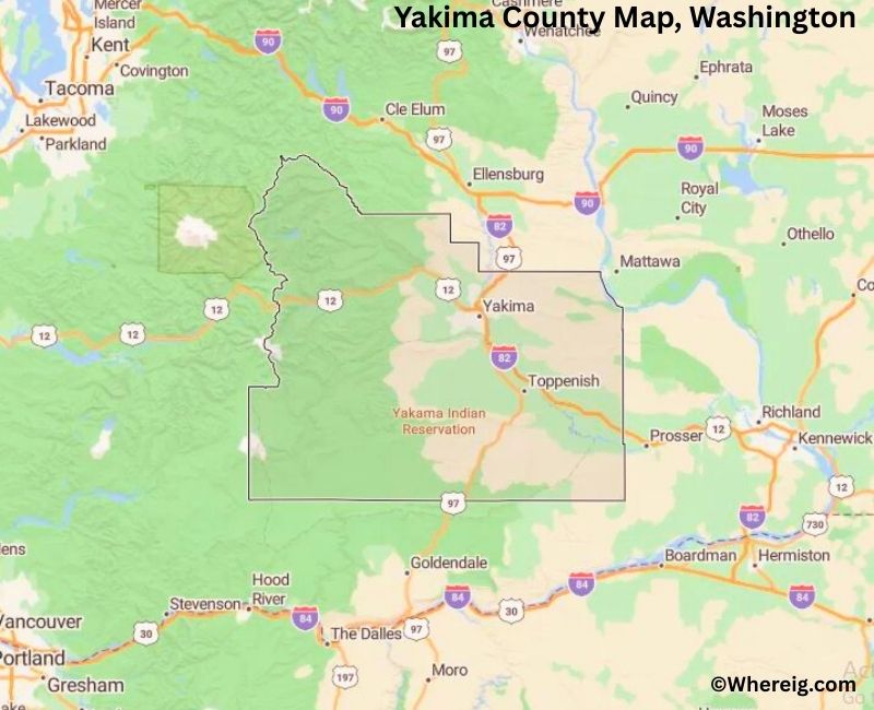
About Yakima County Map, Alabama: The map showing the county boundary, county seat, major cities, highways, water bodies and neighbouring counties.
Most Viewed Links
About Yakima County, Washington
Yakima County is located in the south-central part of Washington, United States, within the fertile Yakima Valley. Established in 1865, the county was named after the Yakama Native American tribe. The county seat and largest city is Yakima, which serves as a regional center for agriculture, commerce, and transportation.
Population
According to the United States Census Bureau, the population of Yakima County was 256,728 as recorded in the 2020 Census. The county includes a mix of urban neighborhoods, farming communities, and rural areas, with many residents living in Yakima, Sunnyside, and Union Gap.
Area and Geography
According to the United States Census Bureau, Yakima County covers a total area of approximately 4,311 square miles, including about 4,295 square miles of land and 16 square miles of water. The county features river valleys, agricultural land, and portions of the Cascade Range that shape its climate and landscape.
Bordering Counties
Yakima County shares borders with Kittitas County to the north, Grant County to the northeast, Benton County to the east, Klickitat County to the south, Skamania County to the southwest, and Lewis County to the west.
Major Cities and Communities
The principal cities in Yakima County include Yakima, Sunnyside, Grandview, Union Gap, and Toppenish. Yakima serves as the county seat and is known for its agricultural production and regional services.
Attractions and Recreation
Yakima County is known for its agricultural heritage, wineries, and outdoor recreation opportunities. Visitors explore vineyards, hiking trails, and scenic drives through the Yakima Valley. The region’s climate and landscape support fruit orchards and hop production that contribute to the county’s economy.
Transportation
Major transportation routes serving Yakima County include Interstate 82 and U.S. Route 12, connecting the county to Seattle, the Tri-Cities region, and other parts of Washington.
Explore more counties in Washington Counties or view the complete USA States Map section for additional geographic information.
Sources:
Population and area data sourced from the United States Census Bureau (2020 Census). General county information referenced from the Official Yakima County Government Website.
Facts about Yakima County, Washington
| Country | United States |
| State | Washington |
| Region | Central Washington |
| County Seat | Yakima |
| Named After | Yakima River (named for the Yakama people) |
| Established | 1865 |
| Organized | 1865 |
| Coordinates | 46.4560° N, 120.7400° W |
| Total Area | 4,311 sq mi |
| Land Area | 4,296 sq mi |
| Water Area | 15 sq mi |
| Population (2020) | 256,728 |
| Population Rank | One of the most populous counties in Central Washington |
| Largest City | Yakima |
| Main Industries | Agriculture, Food Processing, Wine Production, Manufacturing |
| Major Highways | Interstate 82, U.S. Route 12, U.S. Route 97 |
| Time Zone | Pacific Time (UTC−08:00) |
| Known For | Yakima Valley agriculture, Hop production, Wine region |
| Website | https://www.yakimacounty.us |
Top Attractions in Yakima County, Washington
- Yakima Valley Wine Country – Wineries and vineyard views.
- Yakima River Canyon Scenic Byway – Dramatic canyon drive.
- Mount Adams (nearby) – Alpine scenery and hiking.
- Cowiche Canyon Trail – Hiking and desert landscapes.
- Yakima Valley Museum – Regional history exhibits.
- Yakima Greenway – Riverfront walking and biking trail.
- Ginkgo Petrified Forest State Park (nearby) – Petrified wood exhibits.
- Yakima Farmers Market – Local produce and crafts.
- Toppenish National Historic District – Murals and heritage.
- Fort Simcoe Historical State Park – Military history site.
- White Pass Scenic Byway – Mountain driving route.
- Yakima Speedway – Local motorsports events.
Cities & Towns in Yakima County, Washington
Yakima, Sunnyside, Toppenish, Grandview, Union Gap, Selah, Zillah, Mabton, Wapato, Harrah, Tieton, Naches, Buena, Moxee, Outlook, Terrace Heights
- Adams County Map, WA
- Asotin County Map, WA
- Benton County Map, WA
- Chelan County Map, WA
- Clallam County Map, WA
- Clark County Map, WA
- Columbia County Map, WA
- Cowlitz County Map, WA
- Douglas County Map, WA
- Ferry County Map, WA
- Franklin County Map, WA
- Garfield County Map, WA
- Grant County Map, WA
- Grays Harbor County Map, WA
- Island County Map, WA
- Jefferson County Map, WA
- King County Map, WA
- Kitsap County Map, WA
- Kittitas County Map, WA
- Klickitat County Map, WA
- Lewis County Map, WA
- Lincoln County Map, WA
- Mason County Map, WA
- Okanogan County Map, WA
- Pacific County Map, WA
- Pend Oreille County Map, WA
- Pierce County Map, WA
- San Juan County Map, WA
- Skagit County Map, WA
- Skamania County Map, WA
- Snohomish County Map, WA
- Spokane County Map, WA
- Stevens County Map, WA
- Thurston County Map, WA
- Wahkiakum County Map, WA
- Walla Walla County Map, WA
- Whatcom County Map, WA
- Whitman County Map, WA
- Yakima County Map, WA
- Alabama Counties
- Alaska boroughs
- Arizona Counties
- Arkansas Counties
- California County Map
- Colorado Counties
- Connecticut Counties
- Delaware Counties
- Florida County Map
- Georgia County Map
- Hawaii Counties
- Idaho Counties
- Illinois Counties
- Indiana Counties
- Iowa Counties
- Kansas Counties
- Kentucky Counties
- Louisiana Counties
- Maine Counties
- Maryland Counties
- Massachusetts Counties
- Michigan County Map
- Minnesota Counties
- Mississippi Counties
- Missouri Counties
- Montana Counties
- Nebraska Counties
- Nevada Counties
- New York Counties
- New Hampshire Counties
- New Jersey Counties
- New Mexico Counties
- North Carolina Counties
- North Dakota Counties
- Ohio County Map
- Oklahoma Counties
- Oregon Counties
- Pennsylvania Counties
- Rhode Island Counties
- South Carolina Counties
- South Dakota Counties
- Map of Tennessee
- Texas County Map
- Utah Counties
- Vermont Counties
- Virginia Counties
- Washington Counties
- West Virginia Counties
- Wisconsin Counties
- Wyoming Counties