Map of Garfield County - Garfield County is a county located in the U.S. state of Washington. Garfield County Map showing cities, highways, important places and water bodies. Get Where is Garfield County located in the map, major cities in Garfield county, population, areas, and places of interest.
Map of Garfield County, Washington
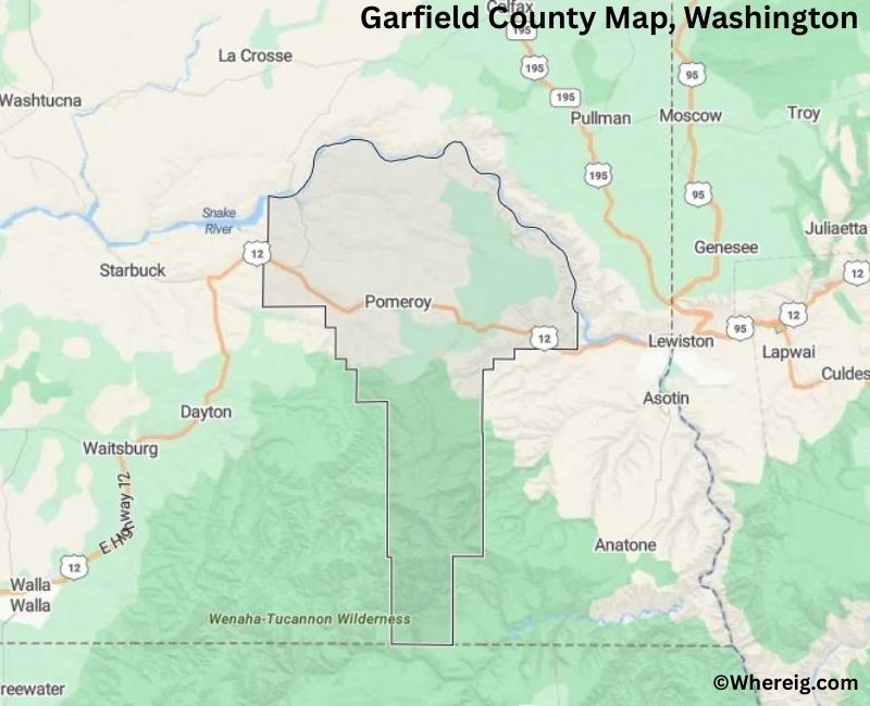
About Garfield County Map, Alabama: The map showing the county boundary, county seat, major cities, highways, water bodies and neighbouring counties.
Most Viewed Links
About Garfield County, Washington
Garfield County is located in the southeastern part of Washington, United States. Established in 1881, the county was named after James A. Garfield, the 20th President of the United States. The county seat and largest city is Pomeroy, which serves as the administrative and economic center of this rural county.
Population
According to the United States Census Bureau, the population of Garfield County was 2,286 as recorded in the 2020 Census. It is one of the least populous counties in Washington, with small communities spread across agricultural and rolling hill landscapes.
Area and Geography
According to the United States Census Bureau, Garfield County covers a total area of approximately 718 square miles, including about 711 square miles of land and 7 square miles of water. The county is characterized by wheat fields, river valleys, and rural terrain typical of southeastern Washington.
Bordering Counties
Garfield County shares borders with Columbia County to the south, Asotin County to the east, Whitman County to the northeast, and Walla Walla County to the west.
Major Cities and Communities
The primary incorporated city in Garfield County is Pomeroy, which serves as the county seat. The county’s small towns and rural communities support a largely agriculture-based economy.
Attractions and Recreation
Garfield County offers scenic countryside, river access, and outdoor recreation opportunities such as fishing, hiking, and camping. The county’s historic buildings and quiet rural landscapes reflect its agricultural heritage and early settlement history.
Transportation
Major transportation routes serving Garfield County include U.S. Route 12 and State Route 127, connecting the county to neighboring communities and other parts of southeastern Washington.
Explore more counties in Washington Counties or view the complete USA States Map section for additional geographic information.
Sources:
Population and area data sourced from the United States Census Bureau (2020 Census). General county information referenced from the Official Garfield County Government Website.
Facts about Garfield County, Washington
| Country | United States |
| State | Washington |
| Region | Southeastern Washington |
| County Seat | Pomeroy |
| Named After | James A. Garfield (20th U.S. President) |
| Established | 1881 |
| Organized | 1881 |
| Coordinates | 46.4310° N, 117.5450° W |
| Total Area | 718 sq mi |
| Land Area | 712 sq mi |
| Water Area | 6 sq mi |
| Population (2020) | 2,363 |
| Population Rank | One of the least populous counties in Washington |
| Largest City | Pomeroy |
| Main Industries | Agriculture, Wheat Farming, Ranching |
| Major Highways | U.S. Route 12, State Route 127 |
| Time Zone | Pacific Time (UTC−08:00) |
| Known For | Wheat fields, Rolling Palouse hills, Rural landscapes |
| Website | https://www.co.garfield.wa.us |
Top Attractions in Garfield County, Washington
- Pomeroy Historic District – County seat with 19th-century buildings.
- Garfield County Courthouse – Historic Richardsonian Romanesque courthouse.
- Pataha Creek Canyon – Scenic canyon and wildlife.
- Palouse Scenic Byway – Rolling hills and farmland views.
- Pataha Creek State Wildlife Area – Fishing and birdwatching.
- Garfield County Museum – Local history exhibits.
- Deadman Creek Road – Scenic rural drive.
- Mayview Historic Area – Small-town heritage site.
- Tucannon River (nearby) – Fishing and river scenery.
- Palouse Prairie Landscapes – Iconic agricultural scenery.
- Pomeroy City Park – Community park and events.
- Scenic Farmland Overlooks – Panoramic countryside views.
Cities & Towns in Garfield County, Washington
Pomeroy, Pataha, Garfield County Rural Communities
- Adams County Map, WA
- Asotin County Map, WA
- Benton County Map, WA
- Chelan County Map, WA
- Clallam County Map, WA
- Clark County Map, WA
- Columbia County Map, WA
- Cowlitz County Map, WA
- Douglas County Map, WA
- Ferry County Map, WA
- Franklin County Map, WA
- Garfield County Map, WA
- Grant County Map, WA
- Grays Harbor County Map, WA
- Island County Map, WA
- Jefferson County Map, WA
- King County Map, WA
- Kitsap County Map, WA
- Kittitas County Map, WA
- Klickitat County Map, WA
- Lewis County Map, WA
- Lincoln County Map, WA
- Mason County Map, WA
- Okanogan County Map, WA
- Pacific County Map, WA
- Pend Oreille County Map, WA
- Pierce County Map, WA
- San Juan County Map, WA
- Skagit County Map, WA
- Skamania County Map, WA
- Snohomish County Map, WA
- Spokane County Map, WA
- Stevens County Map, WA
- Thurston County Map, WA
- Wahkiakum County Map, WA
- Walla Walla County Map, WA
- Whatcom County Map, WA
- Whitman County Map, WA
- Yakima County Map, WA
- Alabama Counties
- Alaska boroughs
- Arizona Counties
- Arkansas Counties
- California County Map
- Colorado Counties
- Connecticut Counties
- Delaware Counties
- Florida County Map
- Georgia County Map
- Hawaii Counties
- Idaho Counties
- Illinois Counties
- Indiana Counties
- Iowa Counties
- Kansas Counties
- Kentucky Counties
- Louisiana Counties
- Maine Counties
- Maryland Counties
- Massachusetts Counties
- Michigan County Map
- Minnesota Counties
- Mississippi Counties
- Missouri Counties
- Montana Counties
- Nebraska Counties
- Nevada Counties
- New York Counties
- New Hampshire Counties
- New Jersey Counties
- New Mexico Counties
- North Carolina Counties
- North Dakota Counties
- Ohio County Map
- Oklahoma Counties
- Oregon Counties
- Pennsylvania Counties
- Rhode Island Counties
- South Carolina Counties
- South Dakota Counties
- Map of Tennessee
- Texas County Map
- Utah Counties
- Vermont Counties
- Virginia Counties
- Washington Counties
- West Virginia Counties
- Wisconsin Counties
- Wyoming Counties