Map of Pierce County - Pierce County is a county located in the U.S. state of Washington. Pierce County Map showing cities, highways, important places and water bodies. Get Where is Pierce County located in the map, major cities in Pierce county, population, areas, and places of interest.
Map of Pierce County, Washington
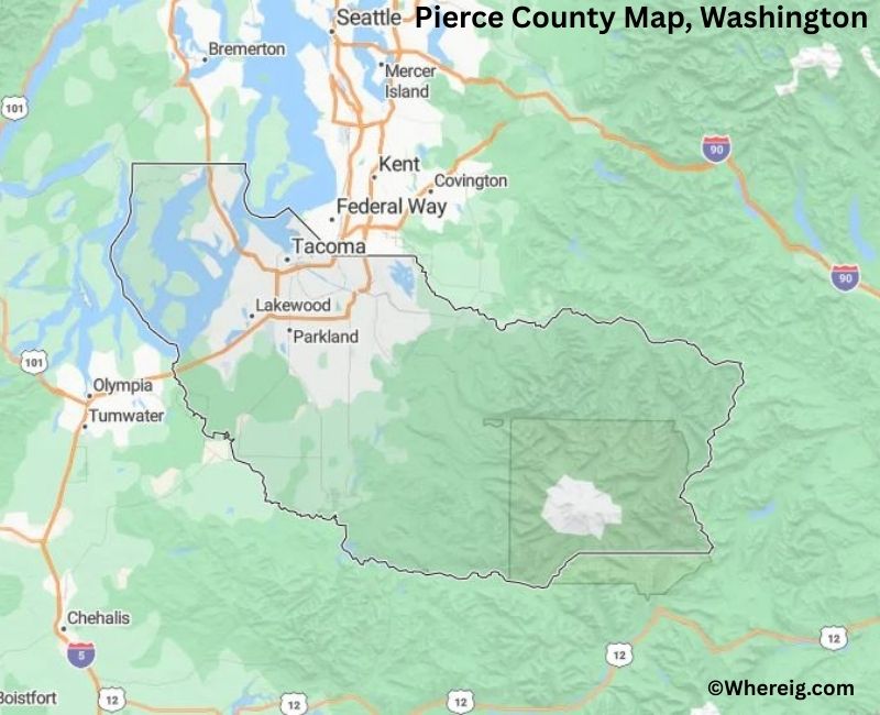
About Pierce County Map, Alabama: The map showing the county boundary, county seat, major cities, highways, water bodies and neighbouring counties.
Most Viewed Links
About Pierce County, Washington
Pierce County is located in the west-central part of Washington, United States, along Puget Sound. Established in 1852, the county was named after Franklin Pierce, the 14th President of the United States. The county seat and largest city is Tacoma, which serves as a major port city and economic center in the region.
Population
According to the United States Census Bureau, the population of Pierce County was 921,130 as recorded in the 2020 Census. It is the second-most populous county in Washington, with residents concentrated in Tacoma and surrounding suburban communities.
Area and Geography
According to the United States Census Bureau, Pierce County covers a total area of approximately 1,806 square miles, including about 1,670 square miles of land and 136 square miles of water. The county includes coastal shoreline, river valleys, forested terrain, and portions of the Cascade Range.
Bordering Counties
Pierce County shares borders with King County to the north, Kittitas County to the east, Yakima County to the southeast, Lewis County to the south, and Thurston County to the southwest.
Major Cities and Communities
The principal cities in Pierce County include Tacoma, Lakewood, Puyallup, University Place, and Gig Harbor. Tacoma serves as the county seat and is known for its port facilities and cultural institutions.
Attractions and Recreation
Pierce County offers diverse recreational opportunities including waterfront parks along Puget Sound and access to Mount Rainier National Park to the southeast. Outdoor activities such as hiking, boating, and skiing attract residents and visitors throughout the year.
Transportation
Major transportation routes serving Pierce County include Interstate 5, State Route 16, and State Route 512, connecting the county to Seattle, Olympia, and other parts of western Washington.
Explore more counties in Washington Counties or view the complete USA States Map section for additional geographic information.
Sources:
Population and area data sourced from the United States Census Bureau (2020 Census). General county information referenced from the Official Pierce County Government Website.
Facts about Pierce County, Washington
| Country | United States |
| State | Washington |
| Region | Central Puget Sound |
| County Seat | Tacoma |
| Named After | Franklin Pierce (14th U.S. President) |
| Established | 1852 |
| Organized | 1852 |
| Coordinates | 47.0379° N, 122.1306° W |
| Total Area | 1,806 sq mi |
| Land Area | 1,670 sq mi |
| Water Area | 136 sq mi |
| Population (2020) | 921,130 |
| Population Rank | Second most populous county in Washington |
| Largest City | Tacoma |
| Main Industries | Healthcare, Military, Manufacturing, Logistics, Education |
| Major Highways | Interstate 5, State Route 16, State Route 512 |
| Major Military Installation | Joint Base Lewis–McChord |
| Time Zone | Pacific Time (UTC−08:00) |
| Known For | Mount Rainier, Tacoma waterfront, Military presence |
| Website | https://www.piercecountywa.gov |
Top Attractions in Pierce County, Washington
- Mount Rainier National Park – Alpine scenery and hiking.
- Point Defiance Park – Zoo, gardens, and waterfront trails.
- Tacoma Museum District – Art and history museums.
- LeMay – America’s Car Museum – Automotive history exhibits.
- Point Defiance Zoo & Aquarium – Major regional zoo.
- Chambers Bay – Golf course and scenic trails.
- Washington State History Museum – State history displays.
- Ruston Way Waterfront – Bay views and walking paths.
- Fort Nisqually Living History Museum – 19th-century fort.
- Mount Rainier Scenic Railroad (nearby) – Scenic train rides.
- Tahoma National Cemetery – Military memorial site.
- Downtown Tacoma – Dining, culture, and events.
Cities & Towns in Pierce County, Washington
Tacoma, Puyallup, Lakewood, University Place, Gig Harbor, Bonney Lake, Sumner, Spanaway, Edgewood, Milton, Fircrest, DuPont, Orting, Fife, Parkland, Steilacoom, South Hill, Ruston, Roy, Eatonville, Carbonado
- Adams County Map, WA
- Asotin County Map, WA
- Benton County Map, WA
- Chelan County Map, WA
- Clallam County Map, WA
- Clark County Map, WA
- Columbia County Map, WA
- Cowlitz County Map, WA
- Douglas County Map, WA
- Ferry County Map, WA
- Franklin County Map, WA
- Garfield County Map, WA
- Grant County Map, WA
- Grays Harbor County Map, WA
- Island County Map, WA
- Jefferson County Map, WA
- King County Map, WA
- Kitsap County Map, WA
- Kittitas County Map, WA
- Klickitat County Map, WA
- Lewis County Map, WA
- Lincoln County Map, WA
- Mason County Map, WA
- Okanogan County Map, WA
- Pacific County Map, WA
- Pend Oreille County Map, WA
- Pierce County Map, WA
- San Juan County Map, WA
- Skagit County Map, WA
- Skamania County Map, WA
- Snohomish County Map, WA
- Spokane County Map, WA
- Stevens County Map, WA
- Thurston County Map, WA
- Wahkiakum County Map, WA
- Walla Walla County Map, WA
- Whatcom County Map, WA
- Whitman County Map, WA
- Yakima County Map, WA
- Alabama Counties
- Alaska boroughs
- Arizona Counties
- Arkansas Counties
- California County Map
- Colorado Counties
- Connecticut Counties
- Delaware Counties
- Florida County Map
- Georgia County Map
- Hawaii Counties
- Idaho Counties
- Illinois Counties
- Indiana Counties
- Iowa Counties
- Kansas Counties
- Kentucky Counties
- Louisiana Counties
- Maine Counties
- Maryland Counties
- Massachusetts Counties
- Michigan County Map
- Minnesota Counties
- Mississippi Counties
- Missouri Counties
- Montana Counties
- Nebraska Counties
- Nevada Counties
- New York Counties
- New Hampshire Counties
- New Jersey Counties
- New Mexico Counties
- North Carolina Counties
- North Dakota Counties
- Ohio County Map
- Oklahoma Counties
- Oregon Counties
- Pennsylvania Counties
- Rhode Island Counties
- South Carolina Counties
- South Dakota Counties
- Map of Tennessee
- Texas County Map
- Utah Counties
- Vermont Counties
- Virginia Counties
- Washington Counties
- West Virginia Counties
- Wisconsin Counties
- Wyoming Counties