Map of Grant County - Grant County is a county located in the U.S. state of Washington. Grant County Map showing cities, highways, important places and water bodies. Get Where is Grant County located in the map, major cities in Grant county, population, areas, and places of interest.
Map of Grant County, Washington
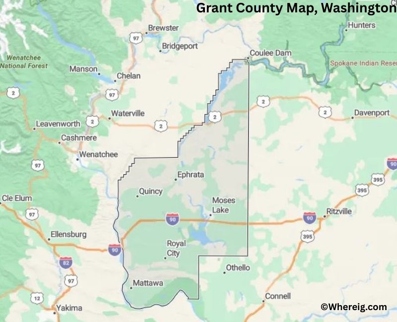
About Grant County Map, Alabama: The map showing the county boundary, county seat, major cities, highways, water bodies and neighbouring counties.
Most Viewed Links
About Grant County, Washington
Grant County is located in the central part of Washington, United States. Established in 1909, the county was named after Ulysses S. Grant, the 18th President of the United States. The county seat is Ephrata, while Moses Lake is the largest city and serves as a major economic center in the region.
Population
According to the United States Census Bureau, the population of Grant County was 99,123 as recorded in the 2020 Census. The county has experienced growth driven by agriculture, food processing, and regional industry, with many residents living in Moses Lake and surrounding communities.
Area and Geography
According to the United States Census Bureau, Grant County covers a total area of approximately 2,791 square miles, including about 2,680 square miles of land and 111 square miles of water. The county lies within the Columbia Basin and includes irrigated farmland, lakes, and semi-arid terrain shaped by large-scale reclamation projects.
Bordering Counties
Grant County shares borders with Okanogan County to the north, Douglas County to the east, Adams County to the south, Lincoln County to the southeast, Kittitas County to the west, and Yakima County to the southwest.
Major Cities and Communities
The principal cities in Grant County include Moses Lake, Ephrata, Quincy, and Soap Lake. Moses Lake is the largest city and serves as a regional center for commerce, industry, and recreation.
Attractions and Recreation
Grant County offers outdoor recreation opportunities centered around Moses Lake and the Columbia Basin. Boating, fishing, camping, and water sports are popular activities. The region is also known for its agricultural landscapes and access to nearby state parks and natural areas.
Transportation
Major transportation routes serving Grant County include Interstate 90, State Route 17, and State Route 28, connecting the county to Spokane, Seattle, and other parts of Washington.
Explore more counties in Washington Counties or view the complete USA States Map section for additional geographic information.
Sources:
Population and area data sourced from the United States Census Bureau (2020 Census). General county information referenced from the Official Grant County Government Website.
Facts about Grant County, Washington
| Country | United States |
| State | Washington |
| Region | Central Washington |
| County Seat | Ephrata |
| Named After | Ulysses S. Grant (18th U.S. President) |
| Established | 1909 |
| Organized | 1909 |
| Coordinates | 47.2000° N, 119.4500° W |
| Total Area | 2,791 sq mi |
| Land Area | 2,681 sq mi |
| Water Area | 110 sq mi |
| Population (2020) | 99,123 |
| Population Rank | Mid-sized county in Washington |
| Largest City | Moses Lake |
| Main Industries | Agriculture, Food Processing, Manufacturing, Renewable Energy |
| Major Highways | Interstate 90, State Route 17, State Route 28 |
| Time Zone | Pacific Time (UTC−08:00) |
| Known For | Columbia Basin Project, Irrigated farmland, Moses Lake |
| Website | https://www.grantcountywa.gov |
Top Attractions in Grant County, Washington
- Sun Lakes–Dry Falls State Park – Dramatic basalt cliffs and lakes.
- Dry Falls – Massive ancient waterfall site.
- Soap Lake – Mineral-rich lake and shoreline.
- Moses Lake – Boating, fishing, and recreation.
- Potholes State Park (nearby) – Sand dunes and reservoirs.
- Columbia National Wildlife Refuge – Desert lakes and birding.
- Wanapum Dam & Heritage Center – River views and culture.
- Ginkgo Petrified Forest State Park (nearby) – Petrified wood exhibits.
- Japanese Peace Garden (Moses Lake) – Quiet lakeside garden.
- Soap Lake Natural Spa – Historic mineral baths.
- Grant County Historical Museum – Local history displays.
- Columbia Basin Farmlands – Expansive agricultural scenery.
Cities & Towns in Grant County, Washington
Moses Lake, Ephrata, Quincy, Grand Coulee, Soap Lake, Coulee City, Royal City, Warden, Mattawa, George, Grant County Rural Communities
- Adams County Map, WA
- Asotin County Map, WA
- Benton County Map, WA
- Chelan County Map, WA
- Clallam County Map, WA
- Clark County Map, WA
- Columbia County Map, WA
- Cowlitz County Map, WA
- Douglas County Map, WA
- Ferry County Map, WA
- Franklin County Map, WA
- Garfield County Map, WA
- Grant County Map, WA
- Grays Harbor County Map, WA
- Island County Map, WA
- Jefferson County Map, WA
- King County Map, WA
- Kitsap County Map, WA
- Kittitas County Map, WA
- Klickitat County Map, WA
- Lewis County Map, WA
- Lincoln County Map, WA
- Mason County Map, WA
- Okanogan County Map, WA
- Pacific County Map, WA
- Pend Oreille County Map, WA
- Pierce County Map, WA
- San Juan County Map, WA
- Skagit County Map, WA
- Skamania County Map, WA
- Snohomish County Map, WA
- Spokane County Map, WA
- Stevens County Map, WA
- Thurston County Map, WA
- Wahkiakum County Map, WA
- Walla Walla County Map, WA
- Whatcom County Map, WA
- Whitman County Map, WA
- Yakima County Map, WA
- Alabama Counties
- Alaska boroughs
- Arizona Counties
- Arkansas Counties
- California County Map
- Colorado Counties
- Connecticut Counties
- Delaware Counties
- Florida County Map
- Georgia County Map
- Hawaii Counties
- Idaho Counties
- Illinois Counties
- Indiana Counties
- Iowa Counties
- Kansas Counties
- Kentucky Counties
- Louisiana Counties
- Maine Counties
- Maryland Counties
- Massachusetts Counties
- Michigan County Map
- Minnesota Counties
- Mississippi Counties
- Missouri Counties
- Montana Counties
- Nebraska Counties
- Nevada Counties
- New York Counties
- New Hampshire Counties
- New Jersey Counties
- New Mexico Counties
- North Carolina Counties
- North Dakota Counties
- Ohio County Map
- Oklahoma Counties
- Oregon Counties
- Pennsylvania Counties
- Rhode Island Counties
- South Carolina Counties
- South Dakota Counties
- Map of Tennessee
- Texas County Map
- Utah Counties
- Vermont Counties
- Virginia Counties
- Washington Counties
- West Virginia Counties
- Wisconsin Counties
- Wyoming Counties