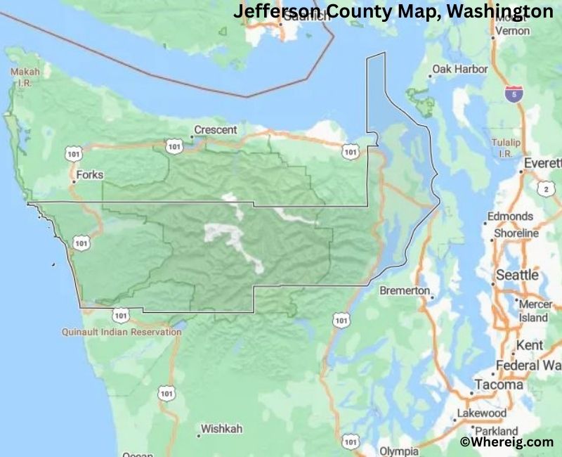
Map of Jefferson County - Jefferson County is a county located in the U.S. state of Washington. Jefferson County Map showing cities, highways, important places and water bodies. Get Where is Jefferson County located in the map, major cities in Jefferson county, population, areas, and places of interest.
Map of Jefferson County, Washington
About Jefferson County Map, Alabama: The map showing the county boundary, county seat, major cities, highways, water bodies and neighbouring counties.
Most Viewed Links
About Jefferson County, Washington
Jefferson County is located in the northwestern part of Washington, United States, on the Olympic Peninsula. Established in 1852, the county was named after Thomas Jefferson, the third President of the United States. The county seat and largest city is Port Townsend, a historic seaport known for its Victorian architecture and maritime heritage.
Population
According to the United States Census Bureau, the population of Jefferson County was 32,977 as recorded in the 2020 Census. The county includes small communities and rural areas, with most residents living in Port Townsend and surrounding coastal regions.
Area and Geography
According to the United States Census Bureau, Jefferson County covers a total area of approximately 2,185 square miles, including about 1,804 square miles of land and 381 square miles of water. The county features forested mountains, inland waterways, and coastal shorelines along Puget Sound and the Pacific Ocean.
Bordering Counties
Jefferson County shares borders with Clallam County to the west, Mason County to the southeast, and Kitsap County across Puget Sound to the east.
Major Cities and Communities
The principal communities in Jefferson County inclu
Facts about Jefferson County, Washington
| Country | United States |
| State | Washington |
| Region | Northwestern Washington |
| County Seat | Port Townsend |
| Named After | Thomas Jefferson (3rd U.S. President) |
| Established | 1852 |
| Organized | 1852 |
| Coordinates | 47.8020° N, 122.9670° W |
| Total Area | 2,183 sq mi |
| Land Area | 1,804 sq mi |
| Water Area | 379 sq mi |
| Population (2020) | 32,808 |
| Population Rank | Smaller mid-sized county in Washington |
| Largest City | Port Townsend |
| Main Industries | Tourism, Healthcare, Forestry, Arts and Culture |
| Major Highways | U.S. Route 101, State Route 20 |
| Time Zone | Pacific Time (UTC−08:00) |
| Known For | Olympic National Park, Victorian architecture, Puget Sound access |
| Website | https://www.co.jefferson.wa.us |
Top Attractions in Jefferson County, Washington
- Olympic National Park (Hoh & Hurricane Ridge nearby) – Mountains, rainforests, and trails.
- Port Townsend Historic District – Victorian architecture and shops.
- Fort Worden State Park – Coastal fort, beaches, and trails.
- Olympic Discovery Trail – Walking and biking route.
- Chimacum Creek Basin – Rural scenery and farms.
- Point Wilson Lighthouse – Historic lighthouse views.
- Jefferson Museum of Art & History – Local exhibits.
- Port Townsend Marine Science Center – Marine education.
- Fort Flagler State Park – Camping and shoreline.
- Marrowstone Island – Quiet beaches and views.
- Finnriver Farm & Cidery – Local cider and events.
- Cape George Colony Club – Scenic coastal trails.
Cities & Towns in Jefferson County, Washington
Port Townsend, Port Hadlock-Irondale, Quilcene, Brinnon, Discovery Bay, Dabob, Jefferson County Rural Communities
- Adams County Map, WA
- Asotin County Map, WA
- Benton County Map, WA
- Chelan County Map, WA
- Clallam County Map, WA
- Clark County Map, WA
- Columbia County Map, WA
- Cowlitz County Map, WA
- Douglas County Map, WA
- Ferry County Map, WA
- Franklin County Map, WA
- Garfield County Map, WA
- Grant County Map, WA
- Grays Harbor County Map, WA
- Island County Map, WA
- Jefferson County Map, WA
- King County Map, WA
- Kitsap County Map, WA
- Kittitas County Map, WA
- Klickitat County Map, WA
- Lewis County Map, WA
- Lincoln County Map, WA
- Mason County Map, WA
- Okanogan County Map, WA
- Pacific County Map, WA
- Pend Oreille County Map, WA
- Pierce County Map, WA
- San Juan County Map, WA
- Skagit County Map, WA
- Skamania County Map, WA
- Snohomish County Map, WA
- Spokane County Map, WA
- Stevens County Map, WA
- Thurston County Map, WA
- Wahkiakum County Map, WA
- Walla Walla County Map, WA
- Whatcom County Map, WA
- Whitman County Map, WA
- Yakima County Map, WA
- Alabama Counties
- Alaska boroughs
- Arizona Counties
- Arkansas Counties
- California County Map
- Colorado Counties
- Connecticut Counties
- Delaware Counties
- Florida County Map
- Georgia County Map
- Hawaii Counties
- Idaho Counties
- Illinois Counties
- Indiana Counties
- Iowa Counties
- Kansas Counties
- Kentucky Counties
- Louisiana Counties
- Maine Counties
- Maryland Counties
- Massachusetts Counties
- Michigan County Map
- Minnesota Counties
- Mississippi Counties
- Missouri Counties
- Montana Counties
- Nebraska Counties
- Nevada Counties
- New York Counties
- New Hampshire Counties
- New Jersey Counties
- New Mexico Counties
- North Carolina Counties
- North Dakota Counties
- Ohio County Map
- Oklahoma Counties
- Oregon Counties
- Pennsylvania Counties
- Rhode Island Counties
- South Carolina Counties
- South Dakota Counties
- Map of Tennessee
- Texas County Map
- Utah Counties
- Vermont Counties
- Virginia Counties
- Washington Counties
- West Virginia Counties
- Wisconsin Counties
- Wyoming Counties