Map of Snohomish County - Snohomish County is a county located in the U.S. state of Washington. Snohomish County Map showing cities, highways, important places and water bodies. Get Where is Snohomish County located in the map, major cities in Snohomish county, population, areas, and places of interest.
Map of Snohomish County, Washington
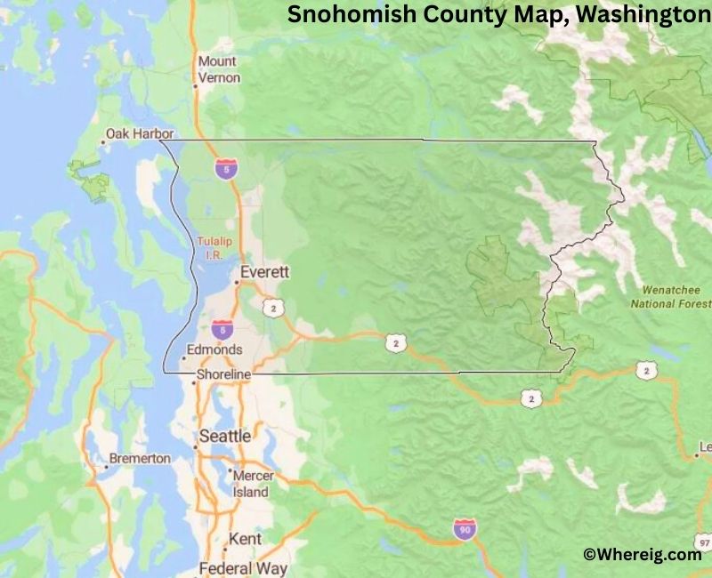
About Snohomish County Map, Alabama: The map showing the county boundary, county seat, major cities, highways, water bodies and neighbouring counties.
Most Viewed Links
About Snohomish County, Washington
Snohomish County is located in the west-central part of Washington, United States, north of Seattle along Puget Sound. Established in 1861, the county was named after the Snohomish Native American tribe. The county seat and largest city is Everett, which serves as a major commercial, industrial, and transportation center in the region.
Population
According to the United States Census Bureau, the population of Snohomish County was 827,957 as recorded in the 2020 Census. It is one of the fastest-growing counties in Washington, with residents concentrated in Everett and surrounding suburban communities.
Area and Geography
According to the United States Census Bureau, Snohomish County covers a total area of approximately 2,196 square miles, including about 2,087 square miles of land and 109 square miles of water. The county includes coastal shoreline, river valleys, forested areas, and portions of the Cascade Range.
Bordering Counties
Snohomish County shares borders with Skagit County to the north, King County to the south, Chelan County to the east, and Kitsap County across Puget Sound to the west.
Major Cities and Communities
The principal cities in Snohomish County include Everett, Lynnwood, Edmonds, Marysville, and Monroe. Everett serves as the county seat and is home to major aerospace manufacturing facilities and port operations.
Attractions and Recreation
Snohomish County offers outdoor recreation opportunities including hiking, boating, skiing, and exploring waterfront parks along Puget Sound. The county’s proximity to the Cascade Mountains and scenic coastal areas attracts residents and visitors year-round.
Transportation
Major transportation routes serving Snohomish County include Interstate 5, U.S. Route 2, and State Route 99, providing connections to Seattle, Bellingham, and eastern Washingt
Facts about Snohomish County, Washington
| Country | United States |
| State | Washington |
| Region | North Puget Sound |
| County Seat | Everett |
| Named After | Snohomish tribe (Native American) |
| Established | 1861 |
| Organized | 1861 |
| Coordinates | 48.0464° N, 121.7210° W |
| Total Area | 2,196 sq mi |
| Land Area | 2,087 sq mi |
| Water Area | 109 sq mi |
| Population (2020) | 827,957 |
| Population Rank | Third most populous county in Washington |
| Largest City | Everett |
| Main Industries | Aerospace, Manufacturing, Technology, Healthcare, Trade |
| Major Highways | Interstate 5, U.S. Route 2, State Route 99 |
| Major Airport | Paine Field (PAE) |
| Time Zone | Pacific Time (UTC−08:00) |
| Known For | Boeing Everett Factory, Puget Sound access, Cascade Mountains |
| Website | https://snohomishcountywa.gov |
Top Attractions in Snohomish County, Washington
- Future of Flight Aviation Center & Boeing Tour – Aircraft exhibits and factory tour.
- Everett Waterfront – Marina views and dining.
- Evergreen Arboretum & Gardens – Botanical gardens.
- Mukilteo Lighthouse Park – Lighthouse and beach views.
- Deception Pass State Park (nearby) – Iconic bridge and trails.
- Wallace Falls State Park – Waterfalls and hiking trails.
- Lake Stevens – Swimming and lakeside recreation.
- Historic Downtown Snohomish – Antique shops and river views.
- Spencer Island Park – Birdwatching and wetland trails.
- North Cascades Scenic Highway – Mountain driving route.
- Jetty Island – Sandy beach and summer ferry.
- Angel of the Winds Arena – Sports and entertainment events.
Cities & Towns in Snohomish County, Washington
Everett, Marysville, Lynnwood, Edmonds, Monroe, Mukilteo, Snohomish, Arlington, Lake Stevens, Mill Creek, Bothell, Mountlake Terrace, Granite Falls, Stanwood, Sultan, Gold Bar, Index, Woodway, Darrington, Brier
- Adams County Map, WA
- Asotin County Map, WA
- Benton County Map, WA
- Chelan County Map, WA
- Clallam County Map, WA
- Clark County Map, WA
- Columbia County Map, WA
- Cowlitz County Map, WA
- Douglas County Map, WA
- Ferry County Map, WA
- Franklin County Map, WA
- Garfield County Map, WA
- Grant County Map, WA
- Grays Harbor County Map, WA
- Island County Map, WA
- Jefferson County Map, WA
- King County Map, WA
- Kitsap County Map, WA
- Kittitas County Map, WA
- Klickitat County Map, WA
- Lewis County Map, WA
- Lincoln County Map, WA
- Mason County Map, WA
- Okanogan County Map, WA
- Pacific County Map, WA
- Pend Oreille County Map, WA
- Pierce County Map, WA
- San Juan County Map, WA
- Skagit County Map, WA
- Skamania County Map, WA
- Snohomish County Map, WA
- Spokane County Map, WA
- Stevens County Map, WA
- Thurston County Map, WA
- Wahkiakum County Map, WA
- Walla Walla County Map, WA
- Whatcom County Map, WA
- Whitman County Map, WA
- Yakima County Map, WA
- Alabama Counties
- Alaska boroughs
- Arizona Counties
- Arkansas Counties
- California County Map
- Colorado Counties
- Connecticut Counties
- Delaware Counties
- Florida County Map
- Georgia County Map
- Hawaii Counties
- Idaho Counties
- Illinois Counties
- Indiana Counties
- Iowa Counties
- Kansas Counties
- Kentucky Counties
- Louisiana Counties
- Maine Counties
- Maryland Counties
- Massachusetts Counties
- Michigan County Map
- Minnesota Counties
- Mississippi Counties
- Missouri Counties
- Montana Counties
- Nebraska Counties
- Nevada Counties
- New York Counties
- New Hampshire Counties
- New Jersey Counties
- New Mexico Counties
- North Carolina Counties
- North Dakota Counties
- Ohio County Map
- Oklahoma Counties
- Oregon Counties
- Pennsylvania Counties
- Rhode Island Counties
- South Carolina Counties
- South Dakota Counties
- Map of Tennessee
- Texas County Map
- Utah Counties
- Vermont Counties
- Virginia Counties
- Washington Counties
- West Virginia Counties
- Wisconsin Counties
- Wyoming Counties