Map of Lincoln County - Lincoln County is a county located in the U.S. state of Washington. Lincoln County Map showing cities, highways, important places and water bodies. Get Where is Lincoln County located in the map, major cities in Lincoln county, population, areas, and places of interest.
Map of Lincoln County, Washington
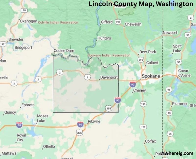
About Lincoln County Map, Alabama: The map showing the county boundary, county seat, major cities, highways, water bodies and neighbouring counties.
Most Viewed Links
About Lincoln County, Washington
Lincoln County is located in the eastern part of Washington, United States. Established in 1883, the county was named after Abraham Lincoln, the 16th President of the United States. The county seat is Davenport, while other communities such as Ritzville and Sprague contribute to the county’s rural character and agricultural economy.
Population
According to the United States Census Bureau, the population of Lincoln County was 10,876 as recorded in the 2020 Census. The county is largely rural, with residents living in small towns and farming communities across the region.
Area and Geography
According to the United States Census Bureau, Lincoln County covers a total area of approximately 2,339 square miles, including about 2,310 square miles of land and 29 square miles of water. The county features rolling wheat fields, open plains, and agricultural landscapes typical of eastern Washington.
Bordering Counties
Lincoln County shares borders with Stevens County to the north, Spokane County to the east, Whitman County to the southeast, Adams County to the south, Grant County to the southwest, and Douglas County to the west.
Major Cities and Communities
The principal communities in Lincoln County include Davenport, Sprague, Almira, and Odessa. Davenport serves as the county seat and administrative center.
Attractions and Recreation
Lincoln County offers scenic agricultural landscapes, small-town heritage sites, and access to outdoor recreation areas. Activities such as fishing, hiking, and exploring historic communities reflect the county’s rural traditions and natural surroundings.
Transportation
Major transportation routes serving Lincoln County include Interstate 90 and U.S. Route 2, providing connections to Spokane and other parts of eastern Washington.
Explore more counties in Washington Counties or view the complete USA States Map section for additional geographic information.
Sources:
Population and area data sourced from the United States Census Bureau (2020 Census). General county information referenced from the Official Lincoln County Government Website.
Facts about Lincoln County, Washington
| Country | United States |
| State | Washington |
| Region | Eastern Washington |
| County Seat | Davenport |
| Named After | Abraham Lincoln (16th U.S. President) |
| Established | 1883 |
| Organized | 1883 |
| Coordinates | 47.5760° N, 118.4190° W |
| Total Area | 2,310 sq mi |
| Land Area | 2,294 sq mi |
| Water Area | 16 sq mi |
| Population (2020) | 10,876 |
| Population Rank | One of the least populous counties in Washington |
| Largest City | Davenport |
| Main Industries | Agriculture, Wheat Farming, Ranching |
| Major Highways | U.S. Route 2, State Route 28 |
| Time Zone | Pacific Time (UTC−08:00) |
| Known For | Wheat fields, Rural landscapes, Columbia Plateau |
| Website | https://www.lincolncountywa.org |
Top Attractions in Lincoln County, Washington
- Lake Roosevelt National Recreation Area (nearby) – Boating and scenic shoreline.
- Sprague Lake – Fishing and lakeside recreation.
- Davenport Historic District – County seat with historic buildings.
- Lincoln County Courthouse – Historic Romanesque courthouse.
- Harrington Historic Area – Small-town charm and history.
- Crab Creek – Fishing and scenic wetlands.
- Turnbull National Wildlife Refuge (nearby) – Lakes and birdwatching.
- Rocklyn Railroad Trestle – Historic rail structure.
- Willow Lake – Quiet recreation lake.
- Lincoln County Historical Society Museum – Local history exhibits.
- Odessa Historic District – Cultural heritage and shops.
- Scenic Wheat Fields – Rolling Palouse farmland views.
Cities & Towns in Lincoln County, Washington
Davenport, Harrington, Sprague, Odessa, Reardan, Almira, Lincoln County Rural Communities
- Adams County Map, WA
- Asotin County Map, WA
- Benton County Map, WA
- Chelan County Map, WA
- Clallam County Map, WA
- Clark County Map, WA
- Columbia County Map, WA
- Cowlitz County Map, WA
- Douglas County Map, WA
- Ferry County Map, WA
- Franklin County Map, WA
- Garfield County Map, WA
- Grant County Map, WA
- Grays Harbor County Map, WA
- Island County Map, WA
- Jefferson County Map, WA
- King County Map, WA
- Kitsap County Map, WA
- Kittitas County Map, WA
- Klickitat County Map, WA
- Lewis County Map, WA
- Lincoln County Map, WA
- Mason County Map, WA
- Okanogan County Map, WA
- Pacific County Map, WA
- Pend Oreille County Map, WA
- Pierce County Map, WA
- San Juan County Map, WA
- Skagit County Map, WA
- Skamania County Map, WA
- Snohomish County Map, WA
- Spokane County Map, WA
- Stevens County Map, WA
- Thurston County Map, WA
- Wahkiakum County Map, WA
- Walla Walla County Map, WA
- Whatcom County Map, WA
- Whitman County Map, WA
- Yakima County Map, WA
- Alabama Counties
- Alaska boroughs
- Arizona Counties
- Arkansas Counties
- California County Map
- Colorado Counties
- Connecticut Counties
- Delaware Counties
- Florida County Map
- Georgia County Map
- Hawaii Counties
- Idaho Counties
- Illinois Counties
- Indiana Counties
- Iowa Counties
- Kansas Counties
- Kentucky Counties
- Louisiana Counties
- Maine Counties
- Maryland Counties
- Massachusetts Counties
- Michigan County Map
- Minnesota Counties
- Mississippi Counties
- Missouri Counties
- Montana Counties
- Nebraska Counties
- Nevada Counties
- New York Counties
- New Hampshire Counties
- New Jersey Counties
- New Mexico Counties
- North Carolina Counties
- North Dakota Counties
- Ohio County Map
- Oklahoma Counties
- Oregon Counties
- Pennsylvania Counties
- Rhode Island Counties
- South Carolina Counties
- South Dakota Counties
- Map of Tennessee
- Texas County Map
- Utah Counties
- Vermont Counties
- Virginia Counties
- Washington Counties
- West Virginia Counties
- Wisconsin Counties
- Wyoming Counties