Map of Cowlitz County - Cowlitz County is a county located in the U.S. state of Washington. Cowlitz County Map showing cities, highways, important places and water bodies. Get Where is Cowlitz County located in the map, major cities in Cowlitz county, population, areas, and places of interest.
Map of Cowlitz County, Washington
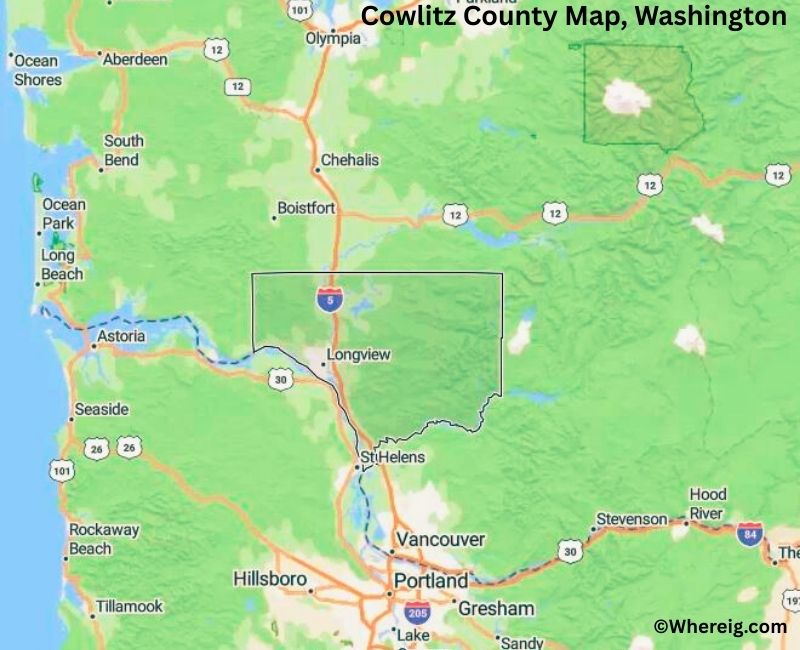
About Cowlitz County Map, Alabama: The map showing the county boundary, county seat, major cities, highways, water bodies and neighbouring counties.
Most Viewed Links
About Cowlitz County, Washington
Cowlitz County is located in the southwestern part of Washington, United States. Established in 1854, the county was named after the Cowlitz Native American tribe. The county seat is Kelso, while Longview is the largest city and serves as the primary commercial and industrial center of the county.
Population
According to the United States Census Bureau, the population of Cowlitz County was 110,730 as recorded in the 2020 Census. The county has a mix of urban and rural communities, with most residents living in Longview and Kelso.
Area and Geography
According to the United States Census Bureau, Cowlitz County covers a total area of approximately 1,166 square miles, including about 1,140 square miles of land and 26 square miles of water. The county features river valleys, forested hills, and access to the Columbia River, which forms part of its southern boundary.
Bordering Counties
Cowlitz County shares borders with Lewis County to the north, Skamania County to the east, and Wahkiakum County to the west. The southern boundary meets the state of Oregon across the Columbia River.
Major Cities and Communities
The principal cities in Cowlitz County include Longview, Kelso, Castle Rock, and Woodland. Longview is the largest city and an important regional center for manufacturing and trade.
Attractions and Recreation
Cowlitz County offers access to outdoor recreation areas including the Columbia River waterfront and nearby forest lands. Mount St. Helens, located to the northeast of the county, draws visitors to the broader region for hiking and sightseeing. Parks, fishing areas, and river activities are popular throughout the county.
Transportation
Major transportation routes serving Cowlitz County include Interstate 5 and State Route 4, providing connections to Seattle, Portland, and other parts of the Pacific Northwest.
Explore more counties in Washington Counties or view the complete USA States Map section for additional geographic information.
Sources:
Population and area data sourced from the United States Census Bureau (2020 Census). General county information referenced from the Official Cowlitz County Government Website.
Facts about Cowlitz County, Washington
| Country | United States |
| State | Washington |
| Region | Southwestern Washington |
| County Seat | Kelso |
| Named After | Cowlitz Tribe of Native Americans |
| Established | 1854 |
| Organized | 1854 |
| Coordinates | 46.1910° N, 122.6950° W |
| Total Area | 1,166 sq mi |
| Land Area | 1,140 sq mi |
| Water Area | 26 sq mi |
| Population (2020) | 110,730 |
| Population Rank | Mid-sized county in Washington |
| Largest City | Longview |
| Main Industries | Manufacturing, Forestry, Paper Products, Healthcare |
| Major Highways | Interstate 5, U.S. Route 30, State Route 432 |
| Time Zone | Pacific Time (UTC−08:00) |
| Known For | Columbia River access, Timber industry, Mount St. Helens proximity |
| Website | https://www.co.cowlitz.wa.us |
Top Attractions in Cowlitz County, Washington
- Mount St. Helens (nearby) – Volcanic scenery and viewpoints.
- Mount St. Helens Visitor Center – Eruption history exhibits.
- Columbia River – Boating and river views.
- Lake Sacajawea Park – Scenic lake and walking paths.
- Tam O’Shanter Park – Riverfront recreation area.
- Three Rivers Mall – Shopping and dining.
- Cowlitz County Historical Museum – Local history exhibits.
- Longview Downtown Riverfront – Parks and waterfront views.
- Lewis River – Fishing and paddling.
- Toutle River Valley – Volcanic landscape views.
- Beacon Hill Scenic Drive – City and river overlooks.
- Mineral Lake (nearby) – Quiet recreation lake.
Cities & Towns in Cowlitz County, Washington
Kelso, Longview, Woodland, Castle Rock, Toutle, Vader, Kalama, Cathlamet, Silver Lake, Ostrander
- Adams County Map, WA
- Asotin County Map, WA
- Benton County Map, WA
- Chelan County Map, WA
- Clallam County Map, WA
- Clark County Map, WA
- Columbia County Map, WA
- Cowlitz County Map, WA
- Douglas County Map, WA
- Ferry County Map, WA
- Franklin County Map, WA
- Garfield County Map, WA
- Grant County Map, WA
- Grays Harbor County Map, WA
- Island County Map, WA
- Jefferson County Map, WA
- King County Map, WA
- Kitsap County Map, WA
- Kittitas County Map, WA
- Klickitat County Map, WA
- Lewis County Map, WA
- Lincoln County Map, WA
- Mason County Map, WA
- Okanogan County Map, WA
- Pacific County Map, WA
- Pend Oreille County Map, WA
- Pierce County Map, WA
- San Juan County Map, WA
- Skagit County Map, WA
- Skamania County Map, WA
- Snohomish County Map, WA
- Spokane County Map, WA
- Stevens County Map, WA
- Thurston County Map, WA
- Wahkiakum County Map, WA
- Walla Walla County Map, WA
- Whatcom County Map, WA
- Whitman County Map, WA
- Yakima County Map, WA
- Alabama Counties
- Alaska boroughs
- Arizona Counties
- Arkansas Counties
- California County Map
- Colorado Counties
- Connecticut Counties
- Delaware Counties
- Florida County Map
- Georgia County Map
- Hawaii Counties
- Idaho Counties
- Illinois Counties
- Indiana Counties
- Iowa Counties
- Kansas Counties
- Kentucky Counties
- Louisiana Counties
- Maine Counties
- Maryland Counties
- Massachusetts Counties
- Michigan County Map
- Minnesota Counties
- Mississippi Counties
- Missouri Counties
- Montana Counties
- Nebraska Counties
- Nevada Counties
- New York Counties
- New Hampshire Counties
- New Jersey Counties
- New Mexico Counties
- North Carolina Counties
- North Dakota Counties
- Ohio County Map
- Oklahoma Counties
- Oregon Counties
- Pennsylvania Counties
- Rhode Island Counties
- South Carolina Counties
- South Dakota Counties
- Map of Tennessee
- Texas County Map
- Utah Counties
- Vermont Counties
- Virginia Counties
- Washington Counties
- West Virginia Counties
- Wisconsin Counties
- Wyoming Counties