Map of Stevens County - Stevens County is a county located in the U.S. state of Washington. Stevens County Map showing cities, highways, important places and water bodies. Get Where is Stevens County located in the map, major cities in Stevens county, population, areas, and places of interest.
Map of Stevens County, Washington
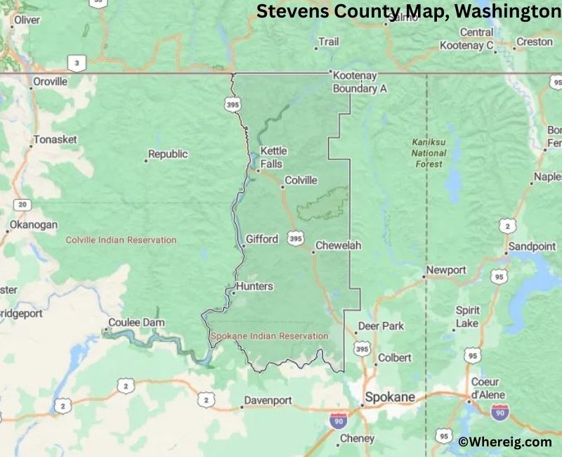
About Stevens County Map, Alabama: The map showing the county boundary, county seat, major cities, highways, water bodies and neighbouring counties.
Most Viewed Links
About Stevens County, Washington
Stevens County is located in the northeastern part of Washington, United States, along the border with Canada. Established in 1863, the county was named after Isaac Stevens, the first governor of Washington Territory. The county seat and largest city is Colville, which serves as the administrative and commercial center of the county.
Population
According to the United States Census Bureau, the population of Stevens County was 46,445 as recorded in the 2020 Census. The county includes small towns and rural communities spread across forested and mountainous terrain.
Area and Geography
According to the United States Census Bureau, Stevens County covers a total area of approximately 2,541 square miles, including about 2,478 square miles of land and 63 square miles of water. The county features river valleys, forests, and portions of the Selkirk Mountains in northeastern Washington.
Bordering Counties
Stevens County shares borders with Pend Oreille County to the east, Spokane County to the south, Lincoln County to the southwest, and Ferry County to the west, while its northern boundary meets Canada.
Major Cities and Communities
The principal communities in Stevens County include Colville, Chewelah, Kettle Falls, and Northport. Colville serves as the county seat and a regional center for government and services.
Attractions and Recreation
Stevens County offers outdoor recreation opportunities including hiking, fishing, camping, and wildlife viewing. The county’s lakes, rivers, and forested landscapes attract visitors seeking nature-based activities throughout the year.
Transportation
Major transportation routes serving Stevens County includ
Facts about Stevens County, Washington
| Country | United States |
| State | Washington |
| Region | Northeastern Washington |
| County Seat | Colville |
| Named After | Isaac Stevens (first Governor of Washington Territory) |
| Established | 1863 |
| Organized | 1863 |
| Coordinates | 48.3960° N, 117.8540° W |
| Total Area | 2,541 sq mi |
| Land Area | 2,478 sq mi |
| Water Area | 63 sq mi |
| Population (2020) | 46,445 |
| Population Rank | Mid-sized county in Washington |
| Largest City | Colville |
| Main Industries | Forestry, Mining, Agriculture, Tourism |
| Major Highways | U.S. Route 395, State Route 20 |
| Time Zone | Pacific Time (UTC−08:00) |
| Known For | Colville National Forest, Outdoor recreation, Mining history |
| Website | https://www.stevenscountywa.gov |
Top Attractions in Stevens County, Washington
- Lake Roosevelt National Recreation Area – Boating and scenic shoreline.
- Colville National Forest – Hiking and wilderness recreation.
- Kettle Falls Historic District – River history and views.
- Northport Historic Area – Small-town charm and river scenery.
- Little Pend Oreille National Wildlife Refuge – Wildlife and trails.
- Dominion Meadows – Open landscapes and hiking.
- Stevens County Historical Society Museum – Local history exhibits.
- Columbia River (upper reaches) – Fishing and scenic views.
- Sheep Creek Wildlife Area – Birdwatching and nature walks.
- Chewelah Peak Scenic Area – Mountain views and hiking.
- 49 Degrees North Mountain Resort – Skiing and winter sports.
- Waitts Lake – Fishing and lakeside recreation.
Cities & Towns in Stevens County, Washington
Colville, Chewelah, Kettle Falls, Northport, Marcus, Loon Lake, Valley, Clayton, Hunters, Springdale, Stevens County Rural Communities
- Adams County Map, WA
- Asotin County Map, WA
- Benton County Map, WA
- Chelan County Map, WA
- Clallam County Map, WA
- Clark County Map, WA
- Columbia County Map, WA
- Cowlitz County Map, WA
- Douglas County Map, WA
- Ferry County Map, WA
- Franklin County Map, WA
- Garfield County Map, WA
- Grant County Map, WA
- Grays Harbor County Map, WA
- Island County Map, WA
- Jefferson County Map, WA
- King County Map, WA
- Kitsap County Map, WA
- Kittitas County Map, WA
- Klickitat County Map, WA
- Lewis County Map, WA
- Lincoln County Map, WA
- Mason County Map, WA
- Okanogan County Map, WA
- Pacific County Map, WA
- Pend Oreille County Map, WA
- Pierce County Map, WA
- San Juan County Map, WA
- Skagit County Map, WA
- Skamania County Map, WA
- Snohomish County Map, WA
- Spokane County Map, WA
- Stevens County Map, WA
- Thurston County Map, WA
- Wahkiakum County Map, WA
- Walla Walla County Map, WA
- Whatcom County Map, WA
- Whitman County Map, WA
- Yakima County Map, WA
- Alabama Counties
- Alaska boroughs
- Arizona Counties
- Arkansas Counties
- California County Map
- Colorado Counties
- Connecticut Counties
- Delaware Counties
- Florida County Map
- Georgia County Map
- Hawaii Counties
- Idaho Counties
- Illinois Counties
- Indiana Counties
- Iowa Counties
- Kansas Counties
- Kentucky Counties
- Louisiana Counties
- Maine Counties
- Maryland Counties
- Massachusetts Counties
- Michigan County Map
- Minnesota Counties
- Mississippi Counties
- Missouri Counties
- Montana Counties
- Nebraska Counties
- Nevada Counties
- New York Counties
- New Hampshire Counties
- New Jersey Counties
- New Mexico Counties
- North Carolina Counties
- North Dakota Counties
- Ohio County Map
- Oklahoma Counties
- Oregon Counties
- Pennsylvania Counties
- Rhode Island Counties
- South Carolina Counties
- South Dakota Counties
- Map of Tennessee
- Texas County Map
- Utah Counties
- Vermont Counties
- Virginia Counties
- Washington Counties
- West Virginia Counties
- Wisconsin Counties
- Wyoming Counties