Map of Whitman County - Whitman County is a county located in the U.S. state of Washington. Whitman County Map showing cities, highways, important places and water bodies. Get Where is Whitman County located in the map, major cities in Whitman county, population, areas, and places of interest.
Map of Whitman County, Washington
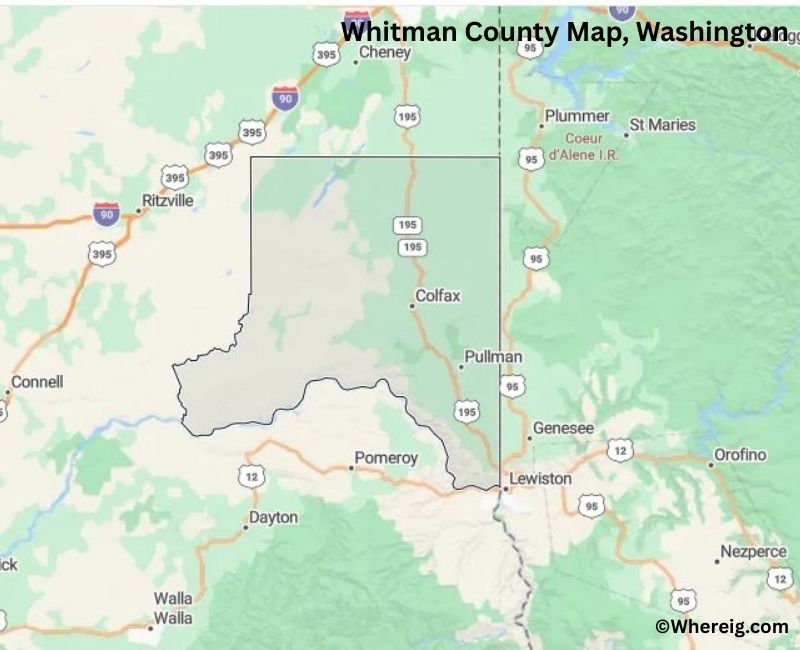
About Whitman County Map, Alabama: The map showing the county boundary, county seat, major cities, highways, water bodies and neighbouring counties.
Most Viewed Links
About Whitman County, Washington
Whitman County is located in the southeastern part of Washington, United States, along the border with Idaho. Established in 1871, the county was named after Marcus Whitman, a missionary and early settler in the region. The county seat and largest city is Colfax, while Pullman is another major community known for its educational institutions.
Population
According to the United States Census Bureau, the population of Whitman County was 47,973 as recorded in the 2020 Census. The county’s population includes students, agricultural communities, and residents living in small towns across the Palouse region.
Area and Geography
According to the United States Census Bureau, Whitman County covers a total area of approximately 2,178 square miles, including about 2,159 square miles of land and 19 square miles of water. The county is characterized by rolling hills, fertile farmland, and river valleys typical of southeastern Washington.
Bordering Counties
Whitman County shares borders with Spokane County to the north, Lincoln County to the northwest, Adams County to the west, Garfield County to the southwest, Columbia County to the south, and the state of Idaho to the east.
Major Cities and Communities
The principal communities in Whitman County include Colfax, Pullman, Palouse, and Tekoa. Colfax serves as the county seat, while Pullman is home to Washington State University and serves as an educational and cultural center.
Attractions and Recreation
Whitman County offers scenic drives through the Palouse hills, agricultural landscapes, and outdoor recreation opportunities including hiking and cycling. University events and cultural activities in Pullman also contribute to the county’s identity.
Transportation
Major transportation routes serving Whitman County include U.S. Route 195 and State Route 26, connecting the county to Spokane and other parts of southeastern Washington.
Explore more counties in Washington Counties or view the complete USA States Map section for additional geographic information.
Sources:
Population and area data sourced from the United States Census Bureau (2020 Census). General county information referenced from the Official Whitman County Government Website.
Facts about Whitman County, Washington
| Country | United States |
| State | Washington |
| Region | Southeastern Washington |
| County Seat | Colfax |
| Named After | Marcus Whitman (missionary and pioneer) |
| Established | 1871 |
| Organized | 1871 |
| Coordinates | 46.9100° N, 117.5250° W |
| Total Area | 2,159 sq mi |
| Land Area | 2,154 sq mi |
| Water Area | 5 sq mi |
| Population (2020) | 47,973 |
| Population Rank | Mid-sized county in Washington |
| Largest City | Pullman |
| Main Industries | Education, Agriculture, Research, Healthcare |
| Major Highways | U.S. Route 195, State Route 26 |
| Time Zone | Pacific Time (UTC−08:00) |
| Known For | Washington State University, Palouse hills, Wheat farming |
| Website | https://www.whitmancounty.org |
Top Attractions in Whitman County, Washington
- Washington State University Campus – Historic college grounds.
- Pullman Historic District – Shops and college-town charm.
- Palouse Falls State Park (nearby) – Dramatic waterfall views.
- Palouse Scenic Byway – Rolling wheat field landscapes.
- Steptoe Butte State Park – Panoramic Palouse views.
- Kamiak Butte County Park – Hiking trails and overlooks.
- WSU Bear Center – Live bear viewing.
- Colfax Downtown Historic District – County seat architecture.
- Palouse River – Scenic river corridor.
- Union Flat Creek Canyon – Canyon scenery.
- Whitman County Historical Society Museum – Local history exhibits.
- Scenic Wheat Fields – Iconic agricultural scenery.
Cities & Towns in Whitman County, Washington
Pullman, Colfax, Tekoa, Palouse, Garfield, Rosalia, Oakesdale, La Crosse, St. John, Almota, Whitman County Rural Communities
- Adams County Map, WA
- Asotin County Map, WA
- Benton County Map, WA
- Chelan County Map, WA
- Clallam County Map, WA
- Clark County Map, WA
- Columbia County Map, WA
- Cowlitz County Map, WA
- Douglas County Map, WA
- Ferry County Map, WA
- Franklin County Map, WA
- Garfield County Map, WA
- Grant County Map, WA
- Grays Harbor County Map, WA
- Island County Map, WA
- Jefferson County Map, WA
- King County Map, WA
- Kitsap County Map, WA
- Kittitas County Map, WA
- Klickitat County Map, WA
- Lewis County Map, WA
- Lincoln County Map, WA
- Mason County Map, WA
- Okanogan County Map, WA
- Pacific County Map, WA
- Pend Oreille County Map, WA
- Pierce County Map, WA
- San Juan County Map, WA
- Skagit County Map, WA
- Skamania County Map, WA
- Snohomish County Map, WA
- Spokane County Map, WA
- Stevens County Map, WA
- Thurston County Map, WA
- Wahkiakum County Map, WA
- Walla Walla County Map, WA
- Whatcom County Map, WA
- Whitman County Map, WA
- Yakima County Map, WA
- Alabama Counties
- Alaska boroughs
- Arizona Counties
- Arkansas Counties
- California County Map
- Colorado Counties
- Connecticut Counties
- Delaware Counties
- Florida County Map
- Georgia County Map
- Hawaii Counties
- Idaho Counties
- Illinois Counties
- Indiana Counties
- Iowa Counties
- Kansas Counties
- Kentucky Counties
- Louisiana Counties
- Maine Counties
- Maryland Counties
- Massachusetts Counties
- Michigan County Map
- Minnesota Counties
- Mississippi Counties
- Missouri Counties
- Montana Counties
- Nebraska Counties
- Nevada Counties
- New York Counties
- New Hampshire Counties
- New Jersey Counties
- New Mexico Counties
- North Carolina Counties
- North Dakota Counties
- Ohio County Map
- Oklahoma Counties
- Oregon Counties
- Pennsylvania Counties
- Rhode Island Counties
- South Carolina Counties
- South Dakota Counties
- Map of Tennessee
- Texas County Map
- Utah Counties
- Vermont Counties
- Virginia Counties
- Washington Counties
- West Virginia Counties
- Wisconsin Counties
- Wyoming Counties