Map of Klickitat County - Klickitat County is a county located in the U.S. state of Washington. Klickitat County Map showing cities, highways, important places and water bodies. Get Where is Klickitat County located in the map, major cities in Klickitat county, population, areas, and places of interest.
Map of Klickitat County, Washington
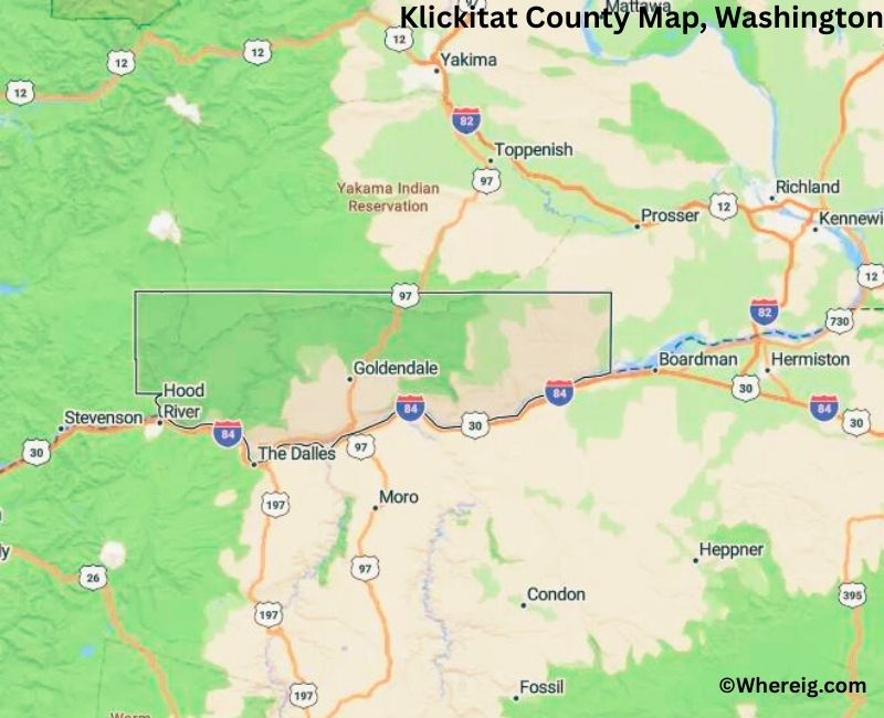
About Klickitat County Map, Alabama: The map showing the county boundary, county seat, major cities, highways, water bodies and neighbouring counties.
Most Viewed Links
About Klickitat County, Washington
Klickitat County is located in the south-central part of Washington, United States, along the Columbia River. Established in 1859, the county was named after the Klickitat Native American tribe. The county seat is Goldendale, while other communities such as White Salmon and Bingen serve as important local centers.
Population
According to the United States Census Bureau, the population of Klickitat County was 22,425 as recorded in the 2020 Census. The county has a largely rural population, with small towns and agricultural communities spread across the region.
Area and Geography
According to the United States Census Bureau, Klickitat County covers a total area of approximately 1,904 square miles, including about 1,871 square miles of land and 33 square miles of water. The county features river valleys, forested areas, and elevated plateaus, with the Columbia River forming much of its southern boundary.
Bordering Counties
Klickitat County shares borders with Yakima County to the north, Benton County to the northeast, and Skamania County to the west. Its southern boundary meets the state of Oregon across the Columbia River.
Major Cities and Communities
The principal communities in Klickitat County include Goldendale, White Salmon, Bingen, and Klickitat. Goldendale serves as the county seat and administrative center.
Attractions and Recreation
Klickitat County is known for scenic views of the Columbia River Gorge and outdoor recreation opportunities. Activities such as hiking, windsurfing, fishing, and camping attract visitors throughout the year. The region also supports agriculture and local wineries that contribute to the county’s economy.
Transportation
Major transportation routes serving Klickitat County include U.S. Route 97 and State Route 14, connecting the county to central Washington and neighboring Oregon.
Explore more counties in Washington Counties or view the complete USA States Map section for additional geographic information.
Sources:
Population and area data sourced from the United States Census Bureau (2020 Census). General county information referenced from the Official Klickitat County Government Website.
Facts about Klickitat County, Washington
| Country | United States |
| State | Washington |
| Region | South-Central Washington |
| County Seat | Goldendale |
| Named After | Klickitat tribe (Native American) |
| Established | 1859 |
| Organized | 1859 |
| Coordinates | 45.8740° N, 120.7350° W |
| Total Area | 1,904 sq mi |
| Land Area | 1,872 sq mi |
| Water Area | 32 sq mi |
| Population (2020) | 22,735 |
| Population Rank | Smaller mid-sized county in Washington |
| Largest City | Goldendale |
| Main Industries | Agriculture, Forestry, Renewable Energy, Tourism |
| Major Highways | U.S. Route 97, State Route 14 |
| Time Zone | Pacific Time (UTC−08:00) |
| Known For | Columbia River Gorge, Wind farms, Goldendale Observatory |
| Website | https://www.klickitatcounty.org |
Top Attractions in Klickitat County, Washington
- Columbia River Gorge – Scenic river canyon and views.
- Maryhill Museum of Art – Art collections and river views.
- Maryhill Stonehenge Memorial – Full-scale Stonehenge replica.
- Columbia Hills State Park – Wildflowers and hiking trails.
- Horsethief Lake State Park – Lakeside recreation.
- Goldendale Observatory State Park – Public astronomy programs.
- Klickitat River – Fishing and rafting.
- Centennial Trail – Walking and biking path.
- Simcoe Mountains – Forest hikes and scenery.
- Lyle Cherry Orchard (seasonal) – Fruit picking and views.
- Goldendale Historic District – Shops and local culture.
- Gorge Wind & Kite Beaches – Windsurfing and kiteboarding.
Cities & Towns in Klickitat County, Washington
Goldendale, Bingen, White Salmon, Lyle, Klickitat, Husum, Dallesport, Lyle, Wishram, Klickitat County Rural Communities
- Adams County Map, WA
- Asotin County Map, WA
- Benton County Map, WA
- Chelan County Map, WA
- Clallam County Map, WA
- Clark County Map, WA
- Columbia County Map, WA
- Cowlitz County Map, WA
- Douglas County Map, WA
- Ferry County Map, WA
- Franklin County Map, WA
- Garfield County Map, WA
- Grant County Map, WA
- Grays Harbor County Map, WA
- Island County Map, WA
- Jefferson County Map, WA
- King County Map, WA
- Kitsap County Map, WA
- Kittitas County Map, WA
- Klickitat County Map, WA
- Lewis County Map, WA
- Lincoln County Map, WA
- Mason County Map, WA
- Okanogan County Map, WA
- Pacific County Map, WA
- Pend Oreille County Map, WA
- Pierce County Map, WA
- San Juan County Map, WA
- Skagit County Map, WA
- Skamania County Map, WA
- Snohomish County Map, WA
- Spokane County Map, WA
- Stevens County Map, WA
- Thurston County Map, WA
- Wahkiakum County Map, WA
- Walla Walla County Map, WA
- Whatcom County Map, WA
- Whitman County Map, WA
- Yakima County Map, WA
- Alabama Counties
- Alaska boroughs
- Arizona Counties
- Arkansas Counties
- California County Map
- Colorado Counties
- Connecticut Counties
- Delaware Counties
- Florida County Map
- Georgia County Map
- Hawaii Counties
- Idaho Counties
- Illinois Counties
- Indiana Counties
- Iowa Counties
- Kansas Counties
- Kentucky Counties
- Louisiana Counties
- Maine Counties
- Maryland Counties
- Massachusetts Counties
- Michigan County Map
- Minnesota Counties
- Mississippi Counties
- Missouri Counties
- Montana Counties
- Nebraska Counties
- Nevada Counties
- New York Counties
- New Hampshire Counties
- New Jersey Counties
- New Mexico Counties
- North Carolina Counties
- North Dakota Counties
- Ohio County Map
- Oklahoma Counties
- Oregon Counties
- Pennsylvania Counties
- Rhode Island Counties
- South Carolina Counties
- South Dakota Counties
- Map of Tennessee
- Texas County Map
- Utah Counties
- Vermont Counties
- Virginia Counties
- Washington Counties
- West Virginia Counties
- Wisconsin Counties
- Wyoming Counties