Map of Kittitas County - Kittitas County is a county located in the U.S. state of Washington. Kittitas County Map showing cities, highways, important places and water bodies. Get Where is Kittitas County located in the map, major cities in Kittitas county, population, areas, and places of interest.
Map of Kittitas County, Washington
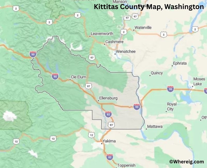
About Kittitas County Map, Alabama: The map showing the county boundary, county seat, major cities, highways, water bodies and neighbouring counties.
Most Viewed Links
About Kittitas County, Washington
Kittitas County is located in the central part of Washington, United States, east of the Cascade Range. Established in 1883, the county was named after a Native American word believed to mean "white chalk" or "shale." The county seat and largest city is Ellensburg, which is also home to Central Washington University.
Population
According to the United States Census Bureau, the population of Kittitas County was 44,866 as recorded in the 2020 Census. The county has a mix of college-town residents, agricultural communities, and rural populations spread across the Kittitas Valley.
Area and Geography
According to the United States Census Bureau, Kittitas County covers a total area of approximately 2,333 square miles, including about 2,297 square miles of land and 36 square miles of water. The county features mountain ranges, river valleys, and open plains, with portions of the Cascade Mountains shaping its western boundary.
Bordering Counties
Kittitas County shares borders with King County to the west, Chelan County to the north, Grant County to the east, Yakima County to the south, and Pierce County to the southwest.
Major Cities and Communities
The principal communities in Kittitas County include Ellensburg, Cle Elum, Roslyn, and Kittitas. Ellensburg serves as the county seat and is known for its educational institutions and annual cultural events.
Attractions and Recreation
Kittitas County offers year-round outdoor recreation, including hiking, skiing, fishing, and camping. The Cascade Mountains and nearby lakes attract visitors seeking scenic landscapes and winter sports, while the Kittitas Valley supports agriculture and rural tourism.
Transportation
Major transportation routes serving Kittitas County include Interstate 90 and U.S. Route 97, providi
Facts about Kittitas County, Washington
| Country | United States |
| State | Washington |
| Region | Central Washington |
| County Seat | Ellensburg |
| Named After | Kittitas tribe (Native American) |
| Established | 1883 |
| Organized | 1883 |
| Coordinates | 47.1240° N, 120.6800° W |
| Total Area | 2,333 sq mi |
| Land Area | 2,297 sq mi |
| Water Area | 36 sq mi |
| Population (2020) | 44,337 |
| Population Rank | Smaller mid-sized county in Washington |
| Largest City | Ellensburg |
| Main Industries | Agriculture, Education, Tourism, Renewable Energy |
| Major Highways | Interstate 90, U.S. Route 97 |
| Time Zone | Pacific Time (UTC−08:00) |
| Known For | Kittitas Valley, Central Washington University, Wind farms |
| Website | https://www.co.kittitas.wa.us |
Top Attractions in Kittitas County, Washington
- Ellensburg Downtown Historic District – Shops, dining, and murals.
- Central Washington University Campus – Historic campus and events.
- Yakima River Canyon Scenic Byway – Dramatic canyon views.
- Yakima River – Fly fishing and rafting.
- Ginkgo Petrified Forest State Park (nearby) – Petrified wood exhibits.
- Manastash Ridge – Hiking and mountain scenery.
- Kittitas County Historical Museum – Local history exhibits.
- Iron Horse State Park (Snoqualmie Tunnel nearby) – Rail trail and tunnel.
- Thorp Mill Town Historic District – Preserved mill-era buildings.
- Umtanum Creek Canyon – Desert canyon hiking.
- Ellensburg Rodeo – Annual professional rodeo event.
- Wilson Creek Winery Area – Local wine tastings.
Cities & Towns in Kitsap County, Washington
Bremerton, Port Orchard, Poulsbo, Bainbridge Island, Silverdale, Kingston, Belfair, Gorst, Hansville, Seabeck, Suquamish
- Adams County Map, WA
- Asotin County Map, WA
- Benton County Map, WA
- Chelan County Map, WA
- Clallam County Map, WA
- Clark County Map, WA
- Columbia County Map, WA
- Cowlitz County Map, WA
- Douglas County Map, WA
- Ferry County Map, WA
- Franklin County Map, WA
- Garfield County Map, WA
- Grant County Map, WA
- Grays Harbor County Map, WA
- Island County Map, WA
- Jefferson County Map, WA
- King County Map, WA
- Kitsap County Map, WA
- Kittitas County Map, WA
- Klickitat County Map, WA
- Lewis County Map, WA
- Lincoln County Map, WA
- Mason County Map, WA
- Okanogan County Map, WA
- Pacific County Map, WA
- Pend Oreille County Map, WA
- Pierce County Map, WA
- San Juan County Map, WA
- Skagit County Map, WA
- Skamania County Map, WA
- Snohomish County Map, WA
- Spokane County Map, WA
- Stevens County Map, WA
- Thurston County Map, WA
- Wahkiakum County Map, WA
- Walla Walla County Map, WA
- Whatcom County Map, WA
- Whitman County Map, WA
- Yakima County Map, WA
- Alabama Counties
- Alaska boroughs
- Arizona Counties
- Arkansas Counties
- California County Map
- Colorado Counties
- Connecticut Counties
- Delaware Counties
- Florida County Map
- Georgia County Map
- Hawaii Counties
- Idaho Counties
- Illinois Counties
- Indiana Counties
- Iowa Counties
- Kansas Counties
- Kentucky Counties
- Louisiana Counties
- Maine Counties
- Maryland Counties
- Massachusetts Counties
- Michigan County Map
- Minnesota Counties
- Mississippi Counties
- Missouri Counties
- Montana Counties
- Nebraska Counties
- Nevada Counties
- New York Counties
- New Hampshire Counties
- New Jersey Counties
- New Mexico Counties
- North Carolina Counties
- North Dakota Counties
- Ohio County Map
- Oklahoma Counties
- Oregon Counties
- Pennsylvania Counties
- Rhode Island Counties
- South Carolina Counties
- South Dakota Counties
- Map of Tennessee
- Texas County Map
- Utah Counties
- Vermont Counties
- Virginia Counties
- Washington Counties
- West Virginia Counties
- Wisconsin Counties
- Wyoming Counties