Map of Pacific County - Pacific County is a county located in the U.S. state of Washington. Pacific County Map showing cities, highways, important places and water bodies. Get Where is Pacific County located in the map, major cities in Pacific county, population, areas, and places of interest.
Map of Pacific County, Washington
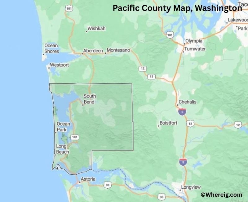
About Pacific County Map, Alabama: The map showing the county boundary, county seat, major cities, highways, water bodies and neighbouring counties.
Most Viewed Links
About Pacific County, Washington
Pacific County is located in the southwestern part of Washington, United States, along the Pacific Ocean. Established in 1851, it is one of the earliest counties formed in Washington Territory. The county seat is South Bend, while other communities such as Raymond and Long Beach serve as important local centers.
Population
According to the United States Census Bureau, the population of Pacific County was 23,365 as recorded in the 2020 Census. The county includes small coastal towns and rural communities, with an economy influenced by fishing, forestry, and tourism.
Area and Geography
According to the United States Census Bureau, Pacific County covers a total area of approximately 1,223 square miles, including about 933 square miles of land and 290 square miles of water. The county features coastal beaches, river estuaries, forested terrain, and access to the Pacific shoreline.
Bordering Counties
Pacific County shares borders with Grays Harbor County to the north, Lewis County to the northeast, and Wahkiakum County to the east. Its southern boundary meets the state of Oregon, while the western boundary lies along the Pacific Ocean.
Major Cities and Communities
The principal communities in Pacific County include South Bend, Raymond, Long Beach, and Ilwaco. South Bend serves as the county seat, while Long Beach is known for its tourism and coastal attractions.
Attractions and Recreation
Pacific County is known for its beaches, fishing
Facts about Pacific County, Washington
| Country | United States |
| State | Washington |
| Region | Southwestern Washington |
| County Seat | South Bend |
| Named After | Pacific Ocean |
| Established | 1851 |
| Organized | 1851 |
| Coordinates | 46.4800° N, 123.9600° W |
| Total Area | 933 sq mi |
| Land Area | 898 sq mi |
| Water Area | 35 sq mi |
| Population (2020) | 23,365 |
| Population Rank | Smaller mid-sized county in Washington |
| Largest City | Long Beach |
| Main Industries | Fishing, Tourism, Forestry, Agriculture |
| Major Highways | U.S. Route 101, State Route 4 |
| Time Zone | Pacific Time (UTC−08:00) |
| Known For | Pacific coastline, Long Beach Peninsula, Seafood industry |
| Website | https://www.co.pacific.wa.us |
Top Attractions in Pacific County, Washington
- Long Beach Peninsula – Wide beaches and coastal views.
- Cape Disappointment State Park – Cliffs, trails, and history.
- North Head Lighthouse – Historic lighthouse and views.
- Lewis and Clark Interpretive Center – Exploration history exhibits.
- Oysterville Historic District – Preserved 19th-century village.
- Willapa Bay – Oysters, wildlife, and kayaking.
- Long Beach Boardwalk – Beachfront walking path.
- Marsh’s Free Museum – Coastal curiosities museum.
- Leadbetter Point State Park – Dunes and birdwatching.
- Ilwaco Waterfront – Harbor, shops, and dining.
- Port of Ilwaco – Fishing boats and marina views.
- Fort Columbia State Park – Historic fort and river views.
Cities & Towns in Pacific County, Washington
Long Beach, Raymond, Ilwaco, South Bend, Ocean Park, Tokeland, Naselle, Menlo, Pacific County Rural Communities
- Adams County Map, WA
- Asotin County Map, WA
- Benton County Map, WA
- Chelan County Map, WA
- Clallam County Map, WA
- Clark County Map, WA
- Columbia County Map, WA
- Cowlitz County Map, WA
- Douglas County Map, WA
- Ferry County Map, WA
- Franklin County Map, WA
- Garfield County Map, WA
- Grant County Map, WA
- Grays Harbor County Map, WA
- Island County Map, WA
- Jefferson County Map, WA
- King County Map, WA
- Kitsap County Map, WA
- Kittitas County Map, WA
- Klickitat County Map, WA
- Lewis County Map, WA
- Lincoln County Map, WA
- Mason County Map, WA
- Okanogan County Map, WA
- Pacific County Map, WA
- Pend Oreille County Map, WA
- Pierce County Map, WA
- San Juan County Map, WA
- Skagit County Map, WA
- Skamania County Map, WA
- Snohomish County Map, WA
- Spokane County Map, WA
- Stevens County Map, WA
- Thurston County Map, WA
- Wahkiakum County Map, WA
- Walla Walla County Map, WA
- Whatcom County Map, WA
- Whitman County Map, WA
- Yakima County Map, WA
- Alabama Counties
- Alaska boroughs
- Arizona Counties
- Arkansas Counties
- California County Map
- Colorado Counties
- Connecticut Counties
- Delaware Counties
- Florida County Map
- Georgia County Map
- Hawaii Counties
- Idaho Counties
- Illinois Counties
- Indiana Counties
- Iowa Counties
- Kansas Counties
- Kentucky Counties
- Louisiana Counties
- Maine Counties
- Maryland Counties
- Massachusetts Counties
- Michigan County Map
- Minnesota Counties
- Mississippi Counties
- Missouri Counties
- Montana Counties
- Nebraska Counties
- Nevada Counties
- New York Counties
- New Hampshire Counties
- New Jersey Counties
- New Mexico Counties
- North Carolina Counties
- North Dakota Counties
- Ohio County Map
- Oklahoma Counties
- Oregon Counties
- Pennsylvania Counties
- Rhode Island Counties
- South Carolina Counties
- South Dakota Counties
- Map of Tennessee
- Texas County Map
- Utah Counties
- Vermont Counties
- Virginia Counties
- Washington Counties
- West Virginia Counties
- Wisconsin Counties
- Wyoming Counties