Map of Walla Walla County - Walla Walla County is a county located in the U.S. state of Washington. Walla Walla County Map showing cities, highways, important places and water bodies. Get Where is Walla Walla County located in the map, major cities in Walla Walla county, population, areas, and places of interest.
Map of Walla Walla County, Washington
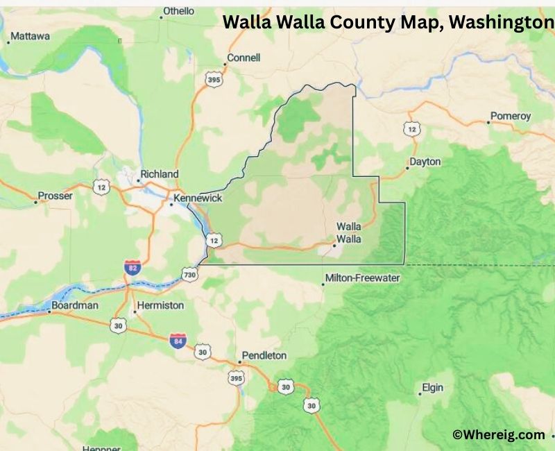
About Walla Walla County Map, Alabama: The map showing the county boundary, county seat, major cities, highways, water bodies and neighbouring counties.
Most Viewed Links
About Walla Walla County, Washington
Walla Walla County is located in the southeastern part of Washington, United States, along the border with Oregon. Established in 1854, the county was named after the Walla Walla Native American tribe. The county seat and largest city is Walla Walla, which serves as a regional center for agriculture, education, and tourism.
Population
According to the United States Census Bureau, the population of Walla Walla County was 62,584 as recorded in the 2020 Census. The county includes urban neighborhoods, farmland, and small communities, with most residents living in and around the city of Walla Walla.
Area and Geography
According to the United States Census Bureau, Walla Walla County covers a total area of approximately 1,297 square miles, including about 1,270 square miles of land and 27 square miles of water. The county features rolling hills, agricultural valleys, and river systems that support farming and viticulture.
Bordering Counties
Walla Walla County shares borders with Columbia County to the north, Garfield County to the northeast, and Franklin County to the west, while its southern boundary meets Oregon.
Major Cities and Communities
The principal communities in Walla Walla County include Walla Walla, College Place, and Waitsburg. Walla Walla serves as the county seat and is widely recognized for its wineries and historic downtown district.
Attractions and Recreation
Walla Walla County is known for its wine industry, scenic countryside, and cultural attractions. Visitors explore local vineyards, historic sites, and outdoor recreation areas throughout the year.
Transportation
Major transportation routes serving Walla Walla County include U.S. Route 12 and State Route 125, connecting the county to other parts of southeastern Washington and neighboring Oregon.
Explore more counties in Washington Counties or view the complete USA States Map section for additional geographic information.
Sources:
Population and area data sourced from the United States Census Bureau (2020 Census). General county information referenced from the Official Walla Walla County Government Website.
Facts about Walla Walla County, Washington
| Country | United States |
| State | Washington |
| Region | Southeastern Washington |
| County Seat | Walla Walla |
| Named After | Walla Walla Tribe (Native American) |
| Established | 1854 |
| Organized | 1854 |
| Coordinates | 46.2300° N, 118.4800° W |
| Total Area | 1,299 sq mi |
| Land Area | 1,270 sq mi |
| Water Area | 29 sq mi |
| Population (2020) | 60,760 |
| Population Rank | Mid-sized county in Washington |
| Largest City | Walla Walla |
| Main Industries | Agriculture, Wine Production, Education, Healthcare |
| Major Highways | U.S. Route 12, U.S. Route 730 |
| Time Zone | Pacific Time (UTC−08:00) |
| Known For | Walla Walla wine region, Wheat farming, Historic downtown |
| Website | https://www.co.walla-walla.wa.us |
Top Attractions in Walla Walla County, Washington
- Walla Walla Wine Country – Renowned wineries and tasting rooms.
- Downtown Walla Walla – Shops, dining, and art galleries.
- Whitman Mission National Historic Site – Historic mission grounds.
- Fort Walla Walla Museum – Regional history exhibits.
- Bennington Lake – Fishing and quiet recreation.
- Blue Mountain Foothills – Scenic drives and hiking.
- Pioneer Park – Central city park.
- Palouse Falls (nearby) – Iconic waterfall views.
- Little Walla Walla River – Scenic river corridor.
- Walla Walla Community College Enology Center – Wine education and tastings.
- Waterbrook Winery Area – Vineyard scenery.
- Walla Walla Fairgrounds – Events and county fair.
Cities & Towns in Walla Walla County, Washington
Walla Walla, College Place, Waitsburg, Prescott, Burbank, Lowden, Touchet, Walla Walla County Rural Communities
- Adams County Map, WA
- Asotin County Map, WA
- Benton County Map, WA
- Chelan County Map, WA
- Clallam County Map, WA
- Clark County Map, WA
- Columbia County Map, WA
- Cowlitz County Map, WA
- Douglas County Map, WA
- Ferry County Map, WA
- Franklin County Map, WA
- Garfield County Map, WA
- Grant County Map, WA
- Grays Harbor County Map, WA
- Island County Map, WA
- Jefferson County Map, WA
- King County Map, WA
- Kitsap County Map, WA
- Kittitas County Map, WA
- Klickitat County Map, WA
- Lewis County Map, WA
- Lincoln County Map, WA
- Mason County Map, WA
- Okanogan County Map, WA
- Pacific County Map, WA
- Pend Oreille County Map, WA
- Pierce County Map, WA
- San Juan County Map, WA
- Skagit County Map, WA
- Skamania County Map, WA
- Snohomish County Map, WA
- Spokane County Map, WA
- Stevens County Map, WA
- Thurston County Map, WA
- Wahkiakum County Map, WA
- Walla Walla County Map, WA
- Whatcom County Map, WA
- Whitman County Map, WA
- Yakima County Map, WA
- Alabama Counties
- Alaska boroughs
- Arizona Counties
- Arkansas Counties
- California County Map
- Colorado Counties
- Connecticut Counties
- Delaware Counties
- Florida County Map
- Georgia County Map
- Hawaii Counties
- Idaho Counties
- Illinois Counties
- Indiana Counties
- Iowa Counties
- Kansas Counties
- Kentucky Counties
- Louisiana Counties
- Maine Counties
- Maryland Counties
- Massachusetts Counties
- Michigan County Map
- Minnesota Counties
- Mississippi Counties
- Missouri Counties
- Montana Counties
- Nebraska Counties
- Nevada Counties
- New York Counties
- New Hampshire Counties
- New Jersey Counties
- New Mexico Counties
- North Carolina Counties
- North Dakota Counties
- Ohio County Map
- Oklahoma Counties
- Oregon Counties
- Pennsylvania Counties
- Rhode Island Counties
- South Carolina Counties
- South Dakota Counties
- Map of Tennessee
- Texas County Map
- Utah Counties
- Vermont Counties
- Virginia Counties
- Washington Counties
- West Virginia Counties
- Wisconsin Counties
- Wyoming Counties