Map of Spokane County - Spokane County is a county located in the U.S. state of Washington. Spokane County Map showing cities, highways, important places and water bodies. Get Where is Spokane County located in the map, major cities in Spokane county, population, areas, and places of interest.
Map of Spokane County, Washington
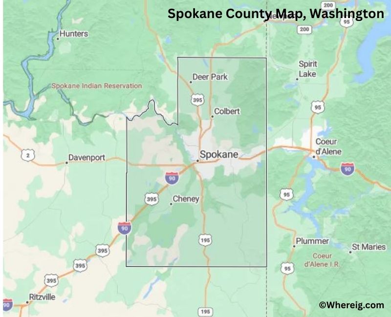
About Spokane County Map, Alabama: The map showing the county boundary, county seat, major cities, highways, water bodies and neighbouring counties.
Most Viewed Links
About Spokane County, Washington
Spokane County is located in the eastern part of Washington, United States, along the border with Idaho. Established in 1858, the county was named after the Spokane Native American tribe. The county seat and largest city is Spokane, which serves as a major economic, educational, and cultural center for eastern Washington.
Population
According to the United States Census Bureau, the population of Spokane County was 539,339 as recorded in the 2020 Census. It is the second-most populous county in eastern Washington, with residents concentrated in Spokane and surrounding suburban communities.
Area and Geography
According to the United States Census Bureau, Spokane County covers a total area of approximately 1,781 square miles, including about 1,764 square miles of land and 17 square miles of water. The county features river systems, rolling hills, forests, and urban centers characteristic of the Inland Northwest region.
Bordering Counties
Spokane County shares borders with Stevens County to the north, Lincoln County to the west, Whitman County to the south, and the state of Idaho to the east.
Major Cities and Communities
The principal cities in Spokane County include Spokane, Spokane Valley, Cheney, and Airway Heights. Spokane serves as the county seat and is the largest city in eastern Washington.
Attractions and Recreation
Spokane County offers urban attractions, parks, and access to outdoor recreation areas. Riverfront Park in downtown Spokane is a major landmark, while nearby lakes and forests provide opportunities for hiking, boating, and skiing throughout the year.
Transportation
Major transportation routes serving Spokane County include Interstate 90, U.S. Route 2, and U.S. Route 395, connecting the county to Seattle, Montana, and neighboring Idaho.
Explore more counties in Washington Counties or view the complete USA States Map section for additional geographic information.
Sources:
Population and area data sourced from the United States Census Bureau (2020 Census). General county information referenced from the Official Spokane County Government Website.
Facts about Spokane County, Washington
| Country | United States |
| State | Washington |
| Region | Eastern Washington |
| County Seat | Spokane |
| Named After | Spokane Tribe (Native American) |
| Established | 1881 |
| Organized | 1881 |
| Coordinates | 47.6210° N, 117.4040° W |
| Total Area | 1,781 sq mi |
| Land Area | 1,764 sq mi |
| Water Area | 17 sq mi |
| Population (2020) | 539,339 |
| Population Rank | Fourth most populous county in Washington |
| Largest City | Spokane |
| Main Industries | Healthcare, Education, Manufacturing, Technology, Trade |
| Major Highways | Interstate 90, U.S. Route 2, U.S. Route 395 |
| Major Airport | Spokane International Airport (GEG) |
| Time Zone | Pacific Time (UTC−08:00) |
| Known For | Spokane Falls, Riverfront Park, Regional healthcare hub |
| Website | https://www.spokanecounty.org |
Top Attractions in Spokane County, Washington
- Riverfront Park – Downtown park with Spokane Falls.
- Spokane Falls – Large urban waterfalls.
- Manito Park & Botanical Gardens – Formal gardens and walks.
- Mount Spokane State Park – Hiking, skiing, and views.
- Northwest Museum of Arts & Culture – Regional history and art.
- Centennial Trail – Riverfront biking and walking path.
- Spokane Valley Heritage Museum – Local history exhibits.
- Avista Stadium – Spokane Indians baseball games.
- Green Bluff – Farms, orchards, and seasonal events.
- John A. Finch Arboretum – Tree collections and trails.
- Downtown Spokane Historic District – Shops, dining, and culture.
- Mobius Discovery Center – Hands-on science exhibits.
Cities & Towns in Spokane County, Washington
Spokane, Spokane Valley, Cheney, Liberty Lake, Medical Lake, Airway Heights, Deer Park, Rockford, Fairfield, Latah, Spangle, Waverly, Opportunity, Millwood, Elk, Mica
- Adams County Map, WA
- Asotin County Map, WA
- Benton County Map, WA
- Chelan County Map, WA
- Clallam County Map, WA
- Clark County Map, WA
- Columbia County Map, WA
- Cowlitz County Map, WA
- Douglas County Map, WA
- Ferry County Map, WA
- Franklin County Map, WA
- Garfield County Map, WA
- Grant County Map, WA
- Grays Harbor County Map, WA
- Island County Map, WA
- Jefferson County Map, WA
- King County Map, WA
- Kitsap County Map, WA
- Kittitas County Map, WA
- Klickitat County Map, WA
- Lewis County Map, WA
- Lincoln County Map, WA
- Mason County Map, WA
- Okanogan County Map, WA
- Pacific County Map, WA
- Pend Oreille County Map, WA
- Pierce County Map, WA
- San Juan County Map, WA
- Skagit County Map, WA
- Skamania County Map, WA
- Snohomish County Map, WA
- Spokane County Map, WA
- Stevens County Map, WA
- Thurston County Map, WA
- Wahkiakum County Map, WA
- Walla Walla County Map, WA
- Whatcom County Map, WA
- Whitman County Map, WA
- Yakima County Map, WA
- Alabama Counties
- Alaska boroughs
- Arizona Counties
- Arkansas Counties
- California County Map
- Colorado Counties
- Connecticut Counties
- Delaware Counties
- Florida County Map
- Georgia County Map
- Hawaii Counties
- Idaho Counties
- Illinois Counties
- Indiana Counties
- Iowa Counties
- Kansas Counties
- Kentucky Counties
- Louisiana Counties
- Maine Counties
- Maryland Counties
- Massachusetts Counties
- Michigan County Map
- Minnesota Counties
- Mississippi Counties
- Missouri Counties
- Montana Counties
- Nebraska Counties
- Nevada Counties
- New York Counties
- New Hampshire Counties
- New Jersey Counties
- New Mexico Counties
- North Carolina Counties
- North Dakota Counties
- Ohio County Map
- Oklahoma Counties
- Oregon Counties
- Pennsylvania Counties
- Rhode Island Counties
- South Carolina Counties
- South Dakota Counties
- Map of Tennessee
- Texas County Map
- Utah Counties
- Vermont Counties
- Virginia Counties
- Washington Counties
- West Virginia Counties
- Wisconsin Counties
- Wyoming Counties