Map of Clallam County - Clallam County is a county located in the U.S. state of Washington. Clallam County Map showing cities, highways, important places and water bodies. Get Where is Clallam County located in the map, major cities in Clallam county, population, areas, and places of interest.
Map of Clallam County, Washington
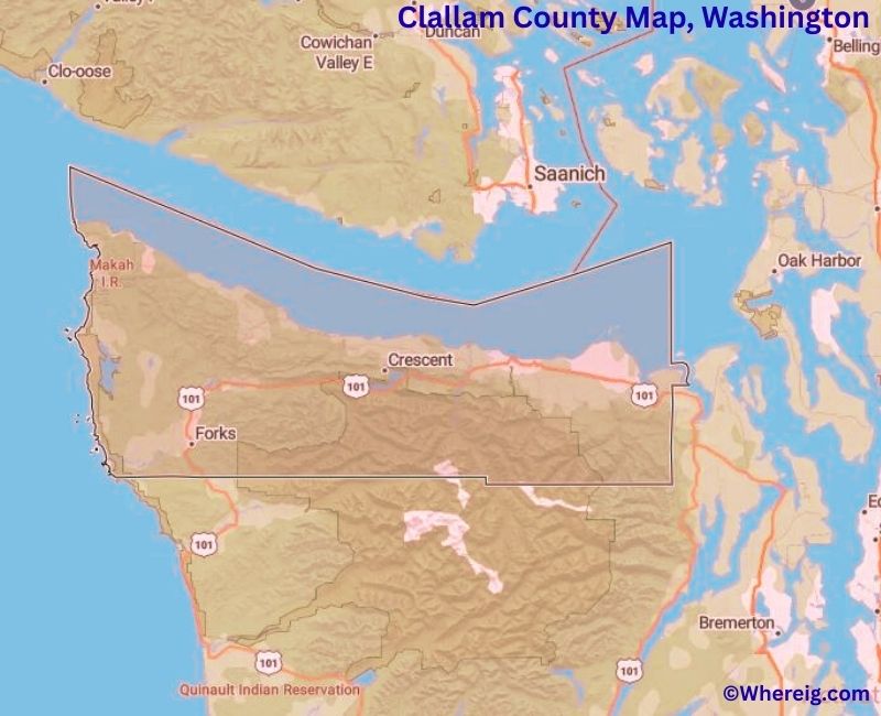
About Clallam County Map, Alabama: The map showing the county boundary, county seat, major cities, highways, water bodies and neighbouring counties.
Most Viewed Links
About Clallam County, Washington
Clallam County is located in the northwestern part of Washington, United States, along the Strait of Juan de Fuca. Established in 1854, the county was named after the Klallam Native American tribe. The county seat and largest city is Port Angeles, which serves as the primary gateway to the Olympic Peninsula and a key regional center.
Population
According to the United States Census Bureau, the population of Clallam County was 77,155 as recorded in the 2020 Census. The county has a mix of small cities and rural communities, with most residents living in Port Angeles, Sequim, and Forks.
Area and Geography
According to the United States Census Bureau, Clallam County covers a total area of approximately 2,671 square miles, including about 1,738 square miles of land and 933 square miles of water. The county includes coastal shorelines, forested mountains, and river valleys that form part of the Olympic Peninsula landscape.
Bordering Counties
Clallam County shares borders with Jefferson County to the southeast and Grays Harbor County to the south. To the north, the county faces Canada across the Strait of Juan de Fuca.
Major Cities and Communities
The principal communities in Clallam County include Port Angeles, Sequim, and Forks. Port Angeles serves as the county seat and a major transportation hub, while Sequim is known for its agricultural production and mild climate. Forks gained national recognition due to its association with popular literature and tourism.
Attractions and Recreation
Clallam County is home to much of Olympic National Park, one of the most visited national parks in the United States. Visitors explore coastal beaches, temperate rainforests, and mountain trails throughout the park. Outdoor recreation, including hiking, fishing, camping, and wildlife viewing, plays an important role in the county’s economy.
Transportation
Major transportation routes serving Clallam County include U.S. Route 101, which connects the county to other parts of Washington and circles much of the Olympic Peninsula.
Explore more counties in Washington Counties or view the complete USA States Map section for additional geographic information.
Sources:
Population and area data sourced from the United States Census Bureau (2020 Census). General county information referenced from the Official Clallam County Government Website.
Facts about Clallam County, Washington
| Country | United States |
| State | Washington |
| Region | Northwestern Washington (Olympic Peninsula) |
| County Seat | Port Angeles |
| Named After | Klallam (S’Klallam) Native American tribe |
| Established | 1854 |
| Organized | 1854 |
| Coordinates | 48.1000° N, 123.5000° W |
| Total Area | 2,671 sq mi |
| Land Area | 1,738 sq mi |
| Water Area | 933 sq mi |
| Population (2020) | 77,155 |
| Population Rank | Mid-sized county in Washington |
| Largest City | Port Angeles |
| Main Industries | Tourism, Healthcare, Forestry, Maritime Services |
| Major Highways | U.S. Route 101, State Route 112 |
| Time Zone | Pacific Time (UTC−08:00) |
| Known For | Olympic National Park, Strait of Juan de Fuca, Coastal scenery |
| Website | https://www.clallamcountywa.gov |
Cities & Towns in Clallam County, Washington
Port Angeles, Sequim, Forks, Port Townsend, Neah Bay, Joyce, Clallam Bay, Blyn, Carlsborg, Diamond Point
- Adams County Map, WA
- Asotin County Map, WA
- Benton County Map, WA
- Chelan County Map, WA
- Clallam County Map, WA
- Clark County Map, WA
- Columbia County Map, WA
- Cowlitz County Map, WA
- Douglas County Map, WA
- Ferry County Map, WA
- Franklin County Map, WA
- Garfield County Map, WA
- Grant County Map, WA
- Grays Harbor County Map, WA
- Island County Map, WA
- Jefferson County Map, WA
- King County Map, WA
- Kitsap County Map, WA
- Kittitas County Map, WA
- Klickitat County Map, WA
- Lewis County Map, WA
- Lincoln County Map, WA
- Mason County Map, WA
- Okanogan County Map, WA
- Pacific County Map, WA
- Pend Oreille County Map, WA
- Pierce County Map, WA
- San Juan County Map, WA
- Skagit County Map, WA
- Skamania County Map, WA
- Snohomish County Map, WA
- Spokane County Map, WA
- Stevens County Map, WA
- Thurston County Map, WA
- Wahkiakum County Map, WA
- Walla Walla County Map, WA
- Whatcom County Map, WA
- Whitman County Map, WA
- Yakima County Map, WA
- Alabama Counties
- Alaska boroughs
- Arizona Counties
- Arkansas Counties
- California County Map
- Colorado Counties
- Connecticut Counties
- Delaware Counties
- Florida County Map
- Georgia County Map
- Hawaii Counties
- Idaho Counties
- Illinois Counties
- Indiana Counties
- Iowa Counties
- Kansas Counties
- Kentucky Counties
- Louisiana Counties
- Maine Counties
- Maryland Counties
- Massachusetts Counties
- Michigan County Map
- Minnesota Counties
- Mississippi Counties
- Missouri Counties
- Montana Counties
- Nebraska Counties
- Nevada Counties
- New York Counties
- New Hampshire Counties
- New Jersey Counties
- New Mexico Counties
- North Carolina Counties
- North Dakota Counties
- Ohio County Map
- Oklahoma Counties
- Oregon Counties
- Pennsylvania Counties
- Rhode Island Counties
- South Carolina Counties
- South Dakota Counties
- Map of Tennessee
- Texas County Map
- Utah Counties
- Vermont Counties
- Virginia Counties
- Washington Counties
- West Virginia Counties
- Wisconsin Counties
- Wyoming Counties