Map of Thurston County - Thurston County is a county located in the U.S. state of Washington. Thurston County Map showing cities, highways, important places and water bodies. Get Where is Thurston County located in the map, major cities in Thurston county, population, areas, and places of interest.
Map of Thurston County, Washington
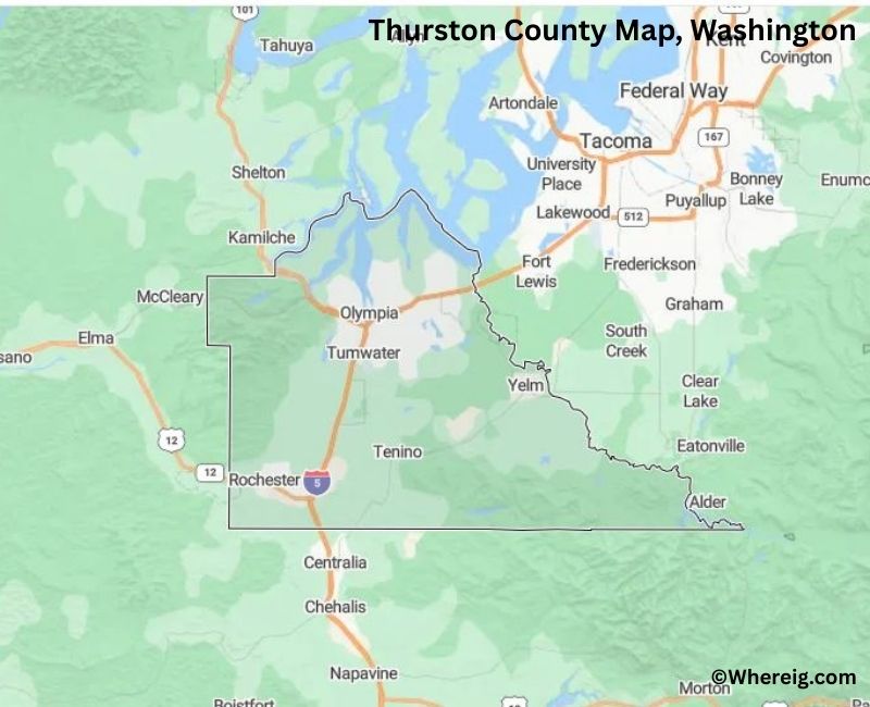
About Thurston County Map, Alabama: The map showing the county boundary, county seat, major cities, highways, water bodies and neighbouring counties.
Most Viewed Links
About Thurston County, Washington
Thurston County is located in the western part of Washington, United States, at the southern end of Puget Sound. Established in 1852, the county was named after Samuel R. Thurston, the first delegate from Oregon Territory to the United States Congress. The county seat and largest city is Olympia, which also serves as the capital of Washington.
Population
According to the United States Census Bureau, the population of Thurston County was 294,793 as recorded in the 2020 Census. The county includes urban centers, suburban communities, and rural areas, with most residents living in Olympia, Lacey, and Tumwater.
Area and Geography
According to the United States Census Bureau, Thurston County covers a total area of approximately 774 square miles, including about 722 square miles of land and 52 square miles of water. The county features shoreline along Puget Sound, forested landscapes, and river valleys in western Washington.
Bordering Counties
Thurston County shares borders with Mason County to the northwest, Grays Harbor County to the west, Lewis County to the south, and Pierce County to the northeast.
Major Cities and Communities
The principal cities in Thurston County include Olympia, Lacey, Tumwater, and Yelm. Olympia serves as the county seat and is home to the Washington State Capitol complex.
Attractions and Recreation
Thurston County offers waterfront parks, historic sites, and outdoor recreation along Puget Sound. Visitors explore the state capitol campus, hiking trails, and nature preserves throughout the county.
Transportation
Major transportation routes serving Thurston County include Interstate 5 and U.S. Route 101, providing connections to Seattle, Portland, and other parts of western Washington.
Explore more counties in Washington Counties or view the complete USA States Map section for additional geographic information.
Sources:
Population and area data sourced from the United States Census Bureau (2020 Census). General county information referenced from the Official Thurston County Government Website.
Facts about Thurston County, Washington
| Country | United States |
| State | Washington |
| Region | South Puget Sound |
| County Seat | Olympia |
| Named After | Samuel R. Thurston (first congressional delegate from Oregon Territory) |
| Established | 1852 |
| Organized | 1852 |
| Coordinates | 47.0400° N, 122.8300° W |
| Total Area | 727 sq mi |
| Land Area | 722 sq mi |
| Water Area | 5 sq mi |
| Population (2020) | 294,793 |
| Population Rank | Sixth most populous county in Washington |
| Largest City | Olympia |
| Main Industries | Government, Healthcare, Education, Retail, Technology |
| Major Highways | Interstate 5, U.S. Route 101, State Route 8 |
| Time Zone | Pacific Time (UTC−08:00) |
| Known For | Washington State Capitol, Puget Sound access, Government center |
| Website | https://www.thurstoncountywa.gov |
Top Attractions in Thurston County, Washington
- Washington State Capitol – Capitol building and campus.
- Capitol State Forest – Hiking and outdoor recreation.
- Hands On Children’s Museum – Interactive family exhibits.
- Olympia Waterfront Park – Harbor views and walking paths.
- Priest Point Park – Forest trails and beaches.
- Tumwater Falls Park – Waterfalls and viewpoints.
- Nisqually National Wildlife Refuge – Birdwatching and wetlands.
- Olympia Farmers Market – Local food and vendors.
- Deschutes Falls Park – River gorge and trails.
- State Capitol Museum (nearby) – State history exhibits.
- Woodard Bay Natural Resources Conservation Area – Boardwalk and wildlife.
- Downtown Olympia – Shops, dining, and culture.
Cities & Towns in Thurston County, Washington
Olympia, Lacey, Tumwater, Yelm, Rainier, Tenino, Bucoda, Rochester, Grand Mound, McCleary, Littlerock, Nisqually, Black Lake, South Bay
- Adams County Map, WA
- Asotin County Map, WA
- Benton County Map, WA
- Chelan County Map, WA
- Clallam County Map, WA
- Clark County Map, WA
- Columbia County Map, WA
- Cowlitz County Map, WA
- Douglas County Map, WA
- Ferry County Map, WA
- Franklin County Map, WA
- Garfield County Map, WA
- Grant County Map, WA
- Grays Harbor County Map, WA
- Island County Map, WA
- Jefferson County Map, WA
- King County Map, WA
- Kitsap County Map, WA
- Kittitas County Map, WA
- Klickitat County Map, WA
- Lewis County Map, WA
- Lincoln County Map, WA
- Mason County Map, WA
- Okanogan County Map, WA
- Pacific County Map, WA
- Pend Oreille County Map, WA
- Pierce County Map, WA
- San Juan County Map, WA
- Skagit County Map, WA
- Skamania County Map, WA
- Snohomish County Map, WA
- Spokane County Map, WA
- Stevens County Map, WA
- Thurston County Map, WA
- Wahkiakum County Map, WA
- Walla Walla County Map, WA
- Whatcom County Map, WA
- Whitman County Map, WA
- Yakima County Map, WA
- Alabama Counties
- Alaska boroughs
- Arizona Counties
- Arkansas Counties
- California County Map
- Colorado Counties
- Connecticut Counties
- Delaware Counties
- Florida County Map
- Georgia County Map
- Hawaii Counties
- Idaho Counties
- Illinois Counties
- Indiana Counties
- Iowa Counties
- Kansas Counties
- Kentucky Counties
- Louisiana Counties
- Maine Counties
- Maryland Counties
- Massachusetts Counties
- Michigan County Map
- Minnesota Counties
- Mississippi Counties
- Missouri Counties
- Montana Counties
- Nebraska Counties
- Nevada Counties
- New York Counties
- New Hampshire Counties
- New Jersey Counties
- New Mexico Counties
- North Carolina Counties
- North Dakota Counties
- Ohio County Map
- Oklahoma Counties
- Oregon Counties
- Pennsylvania Counties
- Rhode Island Counties
- South Carolina Counties
- South Dakota Counties
- Map of Tennessee
- Texas County Map
- Utah Counties
- Vermont Counties
- Virginia Counties
- Washington Counties
- West Virginia Counties
- Wisconsin Counties
- Wyoming Counties