Map of Douglas County - Douglas County is a county located in the U.S. state of Washington. Douglas County Map showing cities, highways, important places and water bodies. Get Where is Douglas County located in the map, major cities in Douglas county, population, areas, and places of interest.
Map of Douglas County, Washington
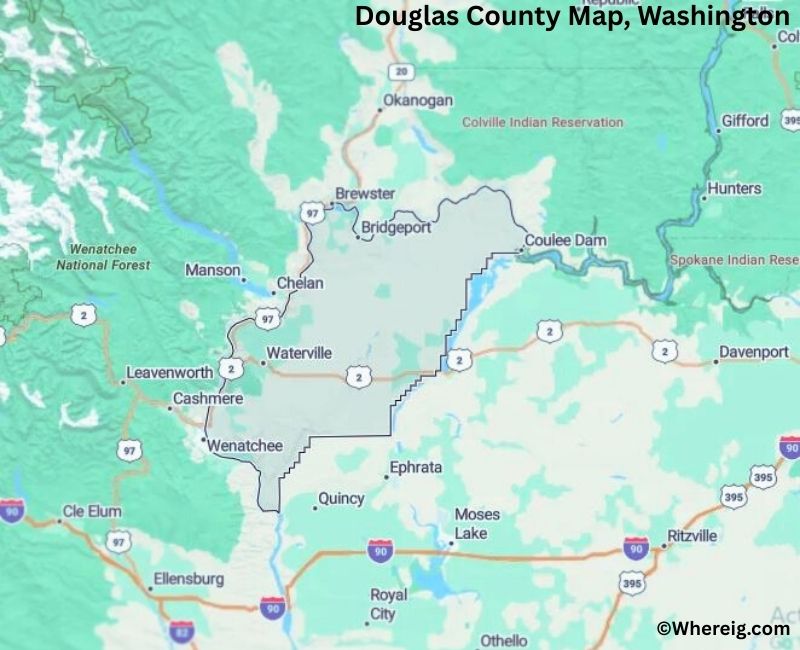
About Douglas County Map, Alabama: The map showing the county boundary, county seat, major cities, highways, water bodies and neighbouring counties.
Most Viewed Links
About Douglas County, Washington
Douglas County is located in the north-central part of Washington, United States, along the eastern bank of the Columbia River. Established in 1883, the county was named after Stephen A. Douglas, a prominent political leader in the mid-19th century. The county seat is Waterville, while East Wenatchee is the largest city and serves as the primary commercial center of the county.
Population
According to the United States Census Bureau, the population of Douglas County was 42,938 as recorded in the 2020 Census. The county has experienced steady growth, with many residents living in East Wenatchee and surrounding communities.
Area and Geography
According to the United States Census Bureau, Douglas County covers a total area of approximately 1,849 square miles, including about 1,819 square miles of land and 30 square miles of water. The Columbia River forms part of the county’s western boundary, and the landscape includes rolling hills, agricultural land, and river valleys typical of central Washington.
Bordering Counties
Douglas County shares borders with Okanogan County to the north, Grant County to the south, Chelan County to the west, and Lincoln County to the east.
Major Cities and Communities
The principal communities in Douglas County include East Wenatchee, Waterville, Bridgeport, and Mansfield. East Wenatchee is the largest city and functions as a regional hub for business and services.
Attractions and Recreation
Douglas County offers outdoor recreation opportunities along the Columbia River, including boating, fishing, and waterfront parks. The surrounding hills and open landscapes provide scenic views and agricultural tourism experiences, reflecting the county’s strong farming heritage.
Transportation
Major transportation routes serving Douglas County include U.S. Route 2, U.S. Route 97, and State Route 28, connecting the county to Wenatchee and other parts of central Washington.
Explore more counties in Washington Counties or view the complete USA States Map section for additional geographic information.
S
Facts about Douglas County, Washington
Country United States State Washington Region North-Central Washington County Seat Waterville Named After Stephen A. Douglas (U.S. Senator) Established 1883 Organized 1883 Coordinates 47.7360° N, 119.6920° W Total Area 1,843 sq mi Land Area 1,815 sq mi Water Area 28 sq mi Population (2020) 43,304 Population Rank Smaller mid-sized county in Washington Largest City East Wenatchee Main Industries Agriculture, Food Processing, Manufacturing Major Highways U.S. Route 2, State Route 28, State Route 97 Time Zone Pacific Time (UTC−08:00) Known For Columbia River Plateau, Farming, Apple orchards Website https://www.douglascountywa.net
Top Attractions in Douglas County, Washington
- Waterville Historic District – County seat with historic buildings.
- Jameson Lake – Fishing and quiet recreation.
- Douglas Creek Canyon – Scenic canyon views.
- Columbia River – Boating and waterfront scenery.
- Bridgeport State Park (nearby) – River access and camping.
- Mansfield Ghost Town – Preserved historic townsite.
- Chief Joseph Dam (nearby) – Large hydroelectric dam.
- Columbia Plateau Farmlands – Rolling agricultural landscapes.
- Badger Mountain Area – Hiking and views.
- Rocky Coulee Scenic Area – Dramatic basalt formations.
- Waterville Museum – Local history exhibits.
- Rural Scenic Drives – Open views of central Washington.
Cities & Towns in Douglas County, Washington
| Country | United States |
| State | Washington |
| Region | North-Central Washington |
| County Seat | Waterville |
| Named After | Stephen A. Douglas (U.S. Senator) |
| Established | 1883 |
| Organized | 1883 |
| Coordinates | 47.7360° N, 119.6920° W |
| Total Area | 1,843 sq mi |
| Land Area | 1,815 sq mi |
| Water Area | 28 sq mi |
| Population (2020) | 43,304 |
| Population Rank | Smaller mid-sized county in Washington |
| Largest City | East Wenatchee |
| Main Industries | Agriculture, Food Processing, Manufacturing |
| Major Highways | U.S. Route 2, State Route 28, State Route 97 |
| Time Zone | Pacific Time (UTC−08:00) |
| Known For | Columbia River Plateau, Farming, Apple orchards |
| Website | https://www.douglascountywa.net |
Mansfield, Waterville, Bridgeport, Coulee City, East Wenatchee, Rock Island, Orondo, Brewster, Douglas County Rural Communities
- Adams County Map, WA
- Asotin County Map, WA
- Benton County Map, WA
- Chelan County Map, WA
- Clallam County Map, WA
- Clark County Map, WA
- Columbia County Map, WA
- Cowlitz County Map, WA
- Douglas County Map, WA
- Ferry County Map, WA
- Franklin County Map, WA
- Garfield County Map, WA
- Grant County Map, WA
- Grays Harbor County Map, WA
- Island County Map, WA
- Jefferson County Map, WA
- King County Map, WA
- Kitsap County Map, WA
- Kittitas County Map, WA
- Klickitat County Map, WA
- Lewis County Map, WA
- Lincoln County Map, WA
- Mason County Map, WA
- Okanogan County Map, WA
- Pacific County Map, WA
- Pend Oreille County Map, WA
- Pierce County Map, WA
- San Juan County Map, WA
- Skagit County Map, WA
- Skamania County Map, WA
- Snohomish County Map, WA
- Spokane County Map, WA
- Stevens County Map, WA
- Thurston County Map, WA
- Wahkiakum County Map, WA
- Walla Walla County Map, WA
- Whatcom County Map, WA
- Whitman County Map, WA
- Yakima County Map, WA
- Alabama Counties
- Alaska boroughs
- Arizona Counties
- Arkansas Counties
- California County Map
- Colorado Counties
- Connecticut Counties
- Delaware Counties
- Florida County Map
- Georgia County Map
- Hawaii Counties
- Idaho Counties
- Illinois Counties
- Indiana Counties
- Iowa Counties
- Kansas Counties
- Kentucky Counties
- Louisiana Counties
- Maine Counties
- Maryland Counties
- Massachusetts Counties
- Michigan County Map
- Minnesota Counties
- Mississippi Counties
- Missouri Counties
- Montana Counties
- Nebraska Counties
- Nevada Counties
- New York Counties
- New Hampshire Counties
- New Jersey Counties
- New Mexico Counties
- North Carolina Counties
- North Dakota Counties
- Ohio County Map
- Oklahoma Counties
- Oregon Counties
- Pennsylvania Counties
- Rhode Island Counties
- South Carolina Counties
- South Dakota Counties
- Map of Tennessee
- Texas County Map
- Utah Counties
- Vermont Counties
- Virginia Counties
- Washington Counties
- West Virginia Counties
- Wisconsin Counties
- Wyoming Counties