Map of Wahkiakum County - Wahkiakum County is a county located in the U.S. state of Washington. Wahkiakum County Map showing cities, highways, important places and water bodies. Get Where is Wahkiakum County located in the map, major cities in Wahkiakum county, population, areas, and places of interest.
Map of Wahkiakum County, Washington
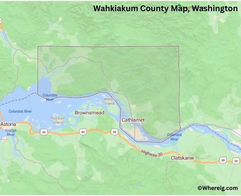
About Wahkiakum County Map, Alabama: The map showing the county boundary, county seat, major cities, highways, water bodies and neighbouring counties.
Most Viewed Links
About Wahkiakum County, Washington
Wahkiakum County is located in the southwestern part of Washington, United States, along the lower Columbia River. Established in 1854, the county was named after a local Native American chief. The county seat and largest community is Cathlamet, which serves as the administrative and economic center of this rural county.
Population
According to the United States Census Bureau, the population of Wahkiakum County was 4,422 as recorded in the 2020 Census. It is one of the least populous counties in Washington, with residents living in small riverfront and rural communities.
Area and Geography
According to the United States Census Bureau, Wahkiakum County covers a total area of approximately 287 square miles, including about 264 square miles of land and 23 square miles of water. The county features river valleys, forested hills, and shoreline along the Columbia River.
Bordering Counties
Wahkiakum County shares borders with Pacific County to the north, Cowlitz County to the east, and Lewis County to the northeast. Its southern boundary meets the state of Oregon across the Columbia River.
Major Cities and Communities
The principal community in Wahkiakum County is Cathlamet, which serves as the county seat. Other small communities contribute to the county’s rural and maritime character.
Attractions and Recreation
Wahkiakum County offers scenic river views, fishing, boating, and quiet rural landscapes. Outdoor recreation along the Columbia River and nearby forested areas attracts visitors seeking peaceful natural surroundings.
Transportation
Major transportation routes serving Wahkiakum County include State Route 4, connecting the county to Longview and other parts of southwestern Washington.
Explore more counties in Washington Counties or view the complete USA States Map section for additional geographic information.
Sources:
Population and area data sourced from the United States Census Bureau (2020 Census). General county information referenced from the Official Wahkiakum County Government Website.
Facts about Wahkiakum County, Washington
| Country | United States |
| State | Washington |
| Region | Southwestern Washington |
| County Seat | Cathlamet |
| Named After | Chief Wahkiakum (Native American leader) |
| Established | 1854 |
| Organized | 1854 |
| Coordinates | 46.2900° N, 123.4300° W |
| Total Area | 287 sq mi |
| Land Area | 263 sq mi |
| Water Area | 24 sq mi |
| Population (2020) | 4,422 |
| Population Rank | One of the least populous counties in Washington |
| Largest City | Cathlamet |
| Main Industries | Fishing, Forestry, Agriculture, Tourism |
| Major Highways | State Route 4 |
| Time Zone | Pacific Time (UTC−08:00) |
| Known For | Columbia River, Rural landscapes, Fishing communities |
| Website | https://www.co.wahkiakum.wa.us |
Top Attractions in Wahkiakum County, Washington
- Julia Butler Hansen Refuge for the Columbian White-Tailed Deer – Wildlife viewing and wetlands.
- Columbia River – Scenic river views and fishing.
- Cathlamet Historic District – River town charm and history.
- Skamokawa Vista Park – River overlook and picnic area.
- Skamokawa Creek – Scenic waterways and kayaking.
- Wahkiakum County Historical Museum – Local history exhibits.
- Puget Island Bridge – Iconic river crossing views.
- Elochoman Slough Marina – Boating and fishing access.
- Grays River Hatchery – Salmon habitat and education.
- Vista Park at Skamokawa – Quiet riverfront park.
- State Route 4 Scenic Drive – River and forest scenery.
- Small River Towns – Historic communities and views.
Cities & Towns in Wahkiakum County, Washington
Cathlamet, Puget Island, Skamokawa, Deep River, Wahkiakum County Rural Communities
- Adams County Map, WA
- Asotin County Map, WA
- Benton County Map, WA
- Chelan County Map, WA
- Clallam County Map, WA
- Clark County Map, WA
- Columbia County Map, WA
- Cowlitz County Map, WA
- Douglas County Map, WA
- Ferry County Map, WA
- Franklin County Map, WA
- Garfield County Map, WA
- Grant County Map, WA
- Grays Harbor County Map, WA
- Island County Map, WA
- Jefferson County Map, WA
- King County Map, WA
- Kitsap County Map, WA
- Kittitas County Map, WA
- Klickitat County Map, WA
- Lewis County Map, WA
- Lincoln County Map, WA
- Mason County Map, WA
- Okanogan County Map, WA
- Pacific County Map, WA
- Pend Oreille County Map, WA
- Pierce County Map, WA
- San Juan County Map, WA
- Skagit County Map, WA
- Skamania County Map, WA
- Snohomish County Map, WA
- Spokane County Map, WA
- Stevens County Map, WA
- Thurston County Map, WA
- Wahkiakum County Map, WA
- Walla Walla County Map, WA
- Whatcom County Map, WA
- Whitman County Map, WA
- Yakima County Map, WA
- Alabama Counties
- Alaska boroughs
- Arizona Counties
- Arkansas Counties
- California County Map
- Colorado Counties
- Connecticut Counties
- Delaware Counties
- Florida County Map
- Georgia County Map
- Hawaii Counties
- Idaho Counties
- Illinois Counties
- Indiana Counties
- Iowa Counties
- Kansas Counties
- Kentucky Counties
- Louisiana Counties
- Maine Counties
- Maryland Counties
- Massachusetts Counties
- Michigan County Map
- Minnesota Counties
- Mississippi Counties
- Missouri Counties
- Montana Counties
- Nebraska Counties
- Nevada Counties
- New York Counties
- New Hampshire Counties
- New Jersey Counties
- New Mexico Counties
- North Carolina Counties
- North Dakota Counties
- Ohio County Map
- Oklahoma Counties
- Oregon Counties
- Pennsylvania Counties
- Rhode Island Counties
- South Carolina Counties
- South Dakota Counties
- Map of Tennessee
- Texas County Map
- Utah Counties
- Vermont Counties
- Virginia Counties
- Washington Counties
- West Virginia Counties
- Wisconsin Counties
- Wyoming Counties