Map of Okanogan County - Okanogan County is a county located in the U.S. state of Washington. Okanogan County Map showing cities, highways, important places and water bodies. Get Where is Okanogan County located in the map, major cities in Okanogan county, population, areas, and places of interest.
Map of Okanogan County, Washington
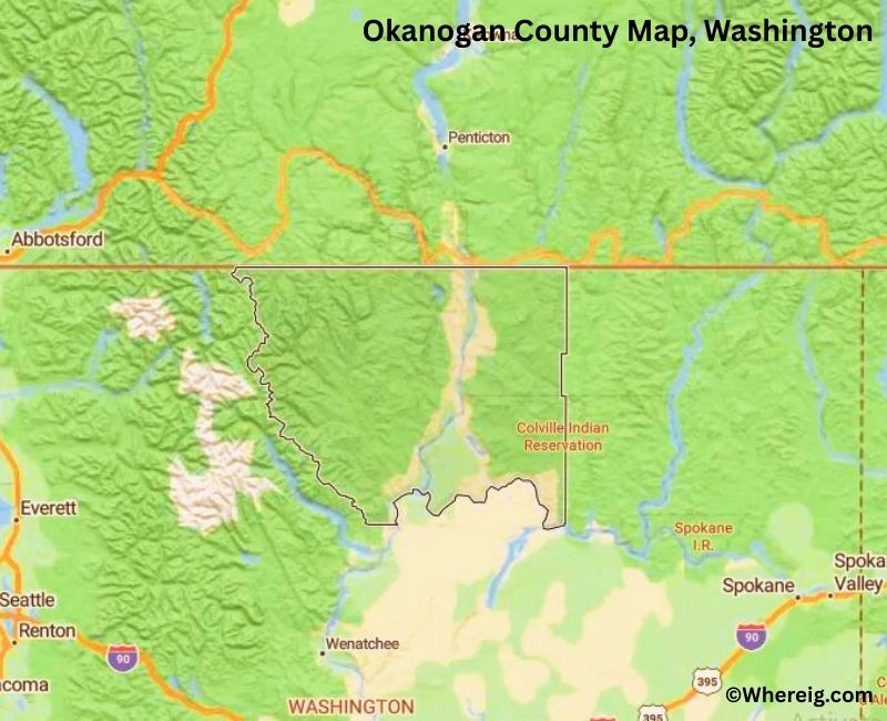
About Okanogan County Map, Alabama: The map showing the county boundary, county seat, major cities, highways, water bodies and neighbouring counties.
Most Viewed Links
About Okanogan County, Washington
Okanogan County is located in the north-central part of Washington, United States, along the border with Canada. Established in 1888, the county was named after the Okanogan River, which flows through the region. The county seat is Okanogan, while Omak is the largest city and serves as a commercial center for the surrounding communities.
Population
According to the United States Census Bureau, the population of Okanogan County was 42,104 as recorded in the 2020 Census. The county includes small cities, rural towns, and agricultural communities spread across a large geographic area.
Area and Geography
According to the United States Census Bureau, Okanogan County covers a total area of approximately 5,315 square miles, including about 5,268 square miles of land and 47 square miles of water. It is the largest county in Washington by land area and features mountain ranges, river valleys, forests, and open rangelands.
Bordering Counties
Okanogan County shares borders with Ferry County to the east, Chelan County to the south, and Douglas County to the southeast, while its northern boundary meets Canada.
Major Cities and Communities
The principal communities in Okanogan County include Omak, Okanogan, Tonasket, and Brewster. Omak is the largest city and a regional center for trade and services.
Attractions and Recreation
Okanogan County offers extensive outdoor recreation opportunities including hiking, fishing, camping, and winter sports. The county’s mountain landscapes and river systems attract visitors seeking scenic drives and nature-based activities throughout the year.
Transportation
Major transportation routes serving Okanogan County include U.S. Route 97 and State Route 20, connecting the county to other parts of north-central Washington.
Explore more counties in Washington Counties or view the complete USA States Map section for additional geographic information.
Sources:
Population and area data sourced from the United States Census Bureau (2020 Census). General county information referenced from the Official Okanogan County Government Website.
Facts about Okanogan County, Washington
| Country | United States |
| State | Washington |
| Region | North-Central Washington |
| County Seat | Okanogan |
| Named After | Okanogan River (derived from a Native American word meaning “meeting place”) |
| Established | 1888 |
| Organized | 1888 |
| Coordinates | 48.3650° N, 119.5300° W |
| Total Area | 5,315 sq mi |
| Land Area | 5,268 sq mi |
| Water Area | 47 sq mi |
| Population (2020) | 42,104 |
| Population Rank | One of the largest counties by area in Washington |
| Largest City | Omak |
| Main Industries | Agriculture, Forestry, Tourism, Ranching |
| Major Highways | U.S. Route 97, State Route 20, State Route 153 |
| Time Zone | Pacific Time (UTC−08:00) |
| Known For | Okanogan Highlands, Agriculture, Outdoor recreation |
| Website | https://www.okanogancounty.org |
Top Attractions in Okanogan County, Washington
- North Cascades National Park (nearby) – Alpine scenery and hiking.
- Lake Chelan (north shore) – Boating and lake views.
- Okanogan-Wenatchee National Forest – Forest trails and camping.
- Winthrop Historic District – Old West–style town.
- Methow Valley – Scenic valley and outdoor recreation.
- Conconully State Park – Camping and fishing lakes.
- Omak Stampede – Annual rodeo and events.
- Pearrygin Lake State Park – Swimming and picnicking.
- Chief Joseph Dam – Hydroelectric dam and views.
- Okanogan County Historical Museum – Local history exhibits.
- TwispWorks – Arts, shops, and events.
- Similkameen River – Fishing and river scenery.
Cities & Towns in Okanogan County, Washington
Omak, Okanogan, Oroville, Tonasket, Brewster, Pateros, Twisp, Winthrop, Conconully, Riverside, Loomis, Malott, Nespelem, Riverside, Carlton, Okanogan County Rural Communities
- Adams County Map, WA
- Asotin County Map, WA
- Benton County Map, WA
- Chelan County Map, WA
- Clallam County Map, WA
- Clark County Map, WA
- Columbia County Map, WA
- Cowlitz County Map, WA
- Douglas County Map, WA
- Ferry County Map, WA
- Franklin County Map, WA
- Garfield County Map, WA
- Grant County Map, WA
- Grays Harbor County Map, WA
- Island County Map, WA
- Jefferson County Map, WA
- King County Map, WA
- Kitsap County Map, WA
- Kittitas County Map, WA
- Klickitat County Map, WA
- Lewis County Map, WA
- Lincoln County Map, WA
- Mason County Map, WA
- Okanogan County Map, WA
- Pacific County Map, WA
- Pend Oreille County Map, WA
- Pierce County Map, WA
- San Juan County Map, WA
- Skagit County Map, WA
- Skamania County Map, WA
- Snohomish County Map, WA
- Spokane County Map, WA
- Stevens County Map, WA
- Thurston County Map, WA
- Wahkiakum County Map, WA
- Walla Walla County Map, WA
- Whatcom County Map, WA
- Whitman County Map, WA
- Yakima County Map, WA
- Alabama Counties
- Alaska boroughs
- Arizona Counties
- Arkansas Counties
- California County Map
- Colorado Counties
- Connecticut Counties
- Delaware Counties
- Florida County Map
- Georgia County Map
- Hawaii Counties
- Idaho Counties
- Illinois Counties
- Indiana Counties
- Iowa Counties
- Kansas Counties
- Kentucky Counties
- Louisiana Counties
- Maine Counties
- Maryland Counties
- Massachusetts Counties
- Michigan County Map
- Minnesota Counties
- Mississippi Counties
- Missouri Counties
- Montana Counties
- Nebraska Counties
- Nevada Counties
- New York Counties
- New Hampshire Counties
- New Jersey Counties
- New Mexico Counties
- North Carolina Counties
- North Dakota Counties
- Ohio County Map
- Oklahoma Counties
- Oregon Counties
- Pennsylvania Counties
- Rhode Island Counties
- South Carolina Counties
- South Dakota Counties
- Map of Tennessee
- Texas County Map
- Utah Counties
- Vermont Counties
- Virginia Counties
- Washington Counties
- West Virginia Counties
- Wisconsin Counties
- Wyoming Counties