Map of Skagit County - Skagit County is a county located in the U.S. state of Washington. Skagit County Map showing cities, highways, important places and water bodies. Get Where is Skagit County located in the map, major cities in Skagit county, population, areas, and places of interest.
Map of Skagit County, Washington
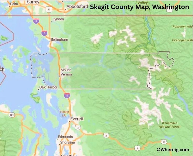
About Skagit County Map, Alabama: The map showing the county boundary, county seat, major cities, highways, water bodies and neighbouring counties.
Most Viewed Links
About Skagit County, Washington
Skagit County is located in the northwestern part of Washington, United States, between Puget Sound and the Cascade Range. Established in 1883, the county was named after the Skagit Native American tribe. The county seat is Mount Vernon, while other major communities include Burlington and Anacortes.
Population
According to the United States Census Bureau, the population of Skagit County was 129,523 as recorded in the 2020 Census. The county includes both urban centers and rural farmland, with many residents living in Mount Vernon and surrounding communities.
Area and Geography
According to the United States Census Bureau, Skagit County covers a total area of approximately 1,920 square miles, including about 1,731 square miles of land and 189 square miles of water. The county features river valleys, agricultural fields, coastal shoreline, and mountainous terrain.
Bordering Counties
Skagit County shares borders with Whatcom County to the north, Okanogan County to the east, Snohomish County to the south, and San Juan County across the Salish Sea to the west.
Major Cities and Communities
The principal cities in Skagit County include Mount Vernon, Burlington, Anacortes, and Sedro-Woolley. Mount Vernon serves as the county seat and is known for its agricultural heritage and annual tulip festival.
Attractions and Recreation
Skagit County offers diverse outdoor recreation opportunities including hiking, boating, and wildlife viewing. The county provides access to North Cascades National Park and scenic coastal areas, attracting visitors throughout the year.
Transportation
Major transportation routes serving Skagit County include Interstate 5 and State Route 20, connecting the county to Seattle, Bellingham, and eastern Washington.
Explore more counties in Washington Counties or view the complete USA States Map section for additional geographic information.
Sources:
Population and area data sourced from the United States Census Bureau (2020 Census). General county information referenced from the Official Skagit County Government Website.
Facts about Skagit County, Washington
| Country | United States |
| State | Washington |
| Region | Northwestern Washington |
| County Seat | Mount Vernon |
| Named After | Skagit River |
| Established | 1883 |
| Organized | 1883 |
| Coordinates | 48.4750° N, 121.8250° W |
| Total Area | 1,849 sq mi |
| Land Area | 1,731 sq mi |
| Water Area | 118 sq mi |
| Population (2020) | 129,523 |
| Population Rank | Mid-sized county in Washington |
| Largest City | Mount Vernon |
| Main Industries | Agriculture, Manufacturing, Energy, Tourism |
| Major Highways | Interstate 5, State Route 20 |
| Time Zone | Pacific Time (UTC−08:00) |
| Known For | Skagit Valley tulips, Hydroelectric dams, Scenic farmland |
| Website | https://www.skagitcounty.net |
Top Attractions in Skagit County, Washington
- North Cascades National Park – Alpine scenery and hiking.
- Deception Pass State Park – Iconic bridge and coastal trails.
- Skagit Valley Tulip Festival – Spring flower fields.
- La Conner Historic District – Waterfront town and shops.
- Skagit Wildlife Area – Birdwatching and wetlands.
- Padilla Bay National Estuarine Research Reserve – Shoreline trails and views.
- Mount Baker Highway – Scenic mountain drive.
- Cascade Loop Scenic Byway – Mountain and valley views.
- Skagit River – Fishing and river scenery.
- Bay View State Park – Beach access and picnicking.
- Museum of Northwest Art – Regional art exhibits.
- Washington Park (Anacortes) – Forest trails and overlooks.
Cities & Towns in Skagit County, Washington
Mount Vernon, Burlington, Anacortes, Sedro-Woolley, La Conner, Concrete, Lyman, Hamilton, Bow, Alger, Bay View
- Adams County Map, WA
- Asotin County Map, WA
- Benton County Map, WA
- Chelan County Map, WA
- Clallam County Map, WA
- Clark County Map, WA
- Columbia County Map, WA
- Cowlitz County Map, WA
- Douglas County Map, WA
- Ferry County Map, WA
- Franklin County Map, WA
- Garfield County Map, WA
- Grant County Map, WA
- Grays Harbor County Map, WA
- Island County Map, WA
- Jefferson County Map, WA
- King County Map, WA
- Kitsap County Map, WA
- Kittitas County Map, WA
- Klickitat County Map, WA
- Lewis County Map, WA
- Lincoln County Map, WA
- Mason County Map, WA
- Okanogan County Map, WA
- Pacific County Map, WA
- Pend Oreille County Map, WA
- Pierce County Map, WA
- San Juan County Map, WA
- Skagit County Map, WA
- Skamania County Map, WA
- Snohomish County Map, WA
- Spokane County Map, WA
- Stevens County Map, WA
- Thurston County Map, WA
- Wahkiakum County Map, WA
- Walla Walla County Map, WA
- Whatcom County Map, WA
- Whitman County Map, WA
- Yakima County Map, WA
- Alabama Counties
- Alaska boroughs
- Arizona Counties
- Arkansas Counties
- California County Map
- Colorado Counties
- Connecticut Counties
- Delaware Counties
- Florida County Map
- Georgia County Map
- Hawaii Counties
- Idaho Counties
- Illinois Counties
- Indiana Counties
- Iowa Counties
- Kansas Counties
- Kentucky Counties
- Louisiana Counties
- Maine Counties
- Maryland Counties
- Massachusetts Counties
- Michigan County Map
- Minnesota Counties
- Mississippi Counties
- Missouri Counties
- Montana Counties
- Nebraska Counties
- Nevada Counties
- New York Counties
- New Hampshire Counties
- New Jersey Counties
- New Mexico Counties
- North Carolina Counties
- North Dakota Counties
- Ohio County Map
- Oklahoma Counties
- Oregon Counties
- Pennsylvania Counties
- Rhode Island Counties
- South Carolina Counties
- South Dakota Counties
- Map of Tennessee
- Texas County Map
- Utah Counties
- Vermont Counties
- Virginia Counties
- Washington Counties
- West Virginia Counties
- Wisconsin Counties
- Wyoming Counties