
Where is Ely Located? - Ely is a city located in the White Pine County of Nevada, United States. Ely lies between 38.4500905 Degrees North latitudes and 81.9293007 Degrees West longitudes.
Location Map of Ely, Nevada
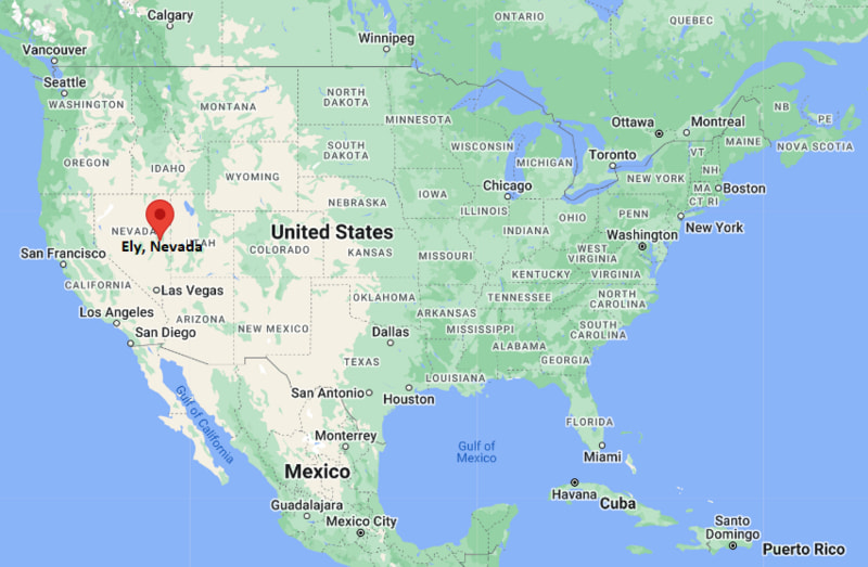
Ely Map, Nevada, USA
Where is Ely?: The Google Map showing the location of Ely in the U.S. state of Nevada.
Where is Ely Located?
Ely is a city located in the White Pine County of Nevada, United States. Ely lies between 38.4500905 Degrees North latitudes and 81.9293007 Degrees West longitudes. According to 2020 U.S.census, the population of Ely city is 3924 people and the city has a total area of 7.63 sq mi. The city has numerous parks and recreational facilities.
Most Viewed US Maps
| USA Sttae Map | USA Region Map | USA Road Map |
| USA County Map | Where is USA in World Map? | US ZIP Code Map |
| USA Time Zones Map | US State and Capitals Map | USA Physical Map |
Find 4,400+ U.S. Cities by State - Explore Their Locations and Get Detailed Information
Ely, Nevada Quick Facts
| Property | Details |
|---|---|
| City | Ely |
| County | White Pine County |
| State | Nevada |
| State Capital | Carson City |
| US Region | West |
| Latitude | 39.2474°N |
| Longitude | 114.8881°W |
| Elevation | 6,437 ft (1,962 m) |
| Land Area | 7.08 sq mi |
| Water Area | 0.00 sq mi |
| Total Area | 7.08 sq mi |
| Population (2020 Census) | 3,924 |
| Population Density | Approximately 554 per sq mi |
| ZIP Code | 89301 |
| Area Code | 775 |
| Time Zone Standard | Pacific Standard Time (PST), UTC−8 |
| Time Zone Daylight | Pacific Daylight Time (PDT), UTC−7 |
| Currency | US Dollar (USD) |
| FIPS Code | 32-23900 |
| Congressional District | Nevada's 2nd Congressional District |
Nearby Cities to Ely, Nevada
- McGill, Nevada - North - 12 mi
- Ruth, Nevada - West - 13 mi
- Cherry Creek, Nevada - North - 54 mi
- Lund, Nevada - South - 35 mi
- Eureka, Nevada - West - 78 mi
- Pioche, Nevada - South - 111 mi
- Delta, Utah - East - 151 mi
- Milford, Utah - Southeast - 145 mi
- Caliente, Nevada - South - 170 mi
- Elko, Nevada - Northwest - 178 mi
Ely, Nevada Climate and Weather Overview
| Month | Avg High (°F) | Avg Low (°F) | Avg Rainfall (in) |
|---|---|---|---|
| January | 37 | 14 | 0.70 |
| April | 58 | 29 | 1.00 |
| July | 84 | 51 | 1.10 |
| October | 62 | 31 | 0.80 |
| Annual | 60 | 31 | 10.00 |
| Climate Attribute | Details |
|---|---|
| Climate Classification (Köppen) | Cold Semi-Arid (BSk) |
| Annual Rainfall | Approximately 10 inches |
| Annual Sunshine Days | About 240 days |
| Hurricane/Tornado Risk | Very low hurricane risk; very low tornado risk |
| Snowfall | Approximately 40 inches annually |
Driving Distances from Ely, Nevada
| City | State | Distance (mi) | Approx. Drive Time |
|---|---|---|---|
| McGill | Nevada | 12 | 15 min |
| Ruth | Nevada | 13 | 18 min |
| Lund | Nevada | 35 | 35 min |
| Cherry Creek | Nevada | 54 | 1 hr |
| Eureka | Nevada | 78 | 1 hr 20 min |
| Pioche | Nevada | 111 | 1 hr 50 min |
| Milford | Utah | 145 | 2 hr 20 min |
| Delta | Utah | 151 | 2 hr 30 min |
| Caliente | Nevada | 170 | 2 hr 45 min |
| Elko | Nevada | 178 | 2 hr 50 min |
Transportation and Connectivity in Ely, Nevada
| Transportation | Details |
|---|---|
| Airport Name | Ely Airport (Yelland Field) |
| IATA Code | ELY |
| Port | None |
| Major Highways | U.S. Route 50, U.S. Route 6, U.S. Route 93, Nevada State Route 490 |
| Train/Amtrak Service | No Amtrak service; Nevada Northern Railway offers heritage rail excursions |
| Local Bus/Transit Service | Limited regional transportation services |
- U.S. Routes 50, 6, and 93 intersect in Ely, making it one of eastern Nevada's most important highway crossroads.
- Ely Airport (Yelland Field) supports general aviation, charter flights, and aviation services.
- The Nevada Northern Railway Museum operates historic steam and diesel train excursions that attract visitors throughout the year.
- The city serves as the primary transportation, commercial, and tourism hub for White Pine County and nearby Great Basin attractions.
Places to Visit in Ely, Nevada
| Landmark Name | Type |
|---|---|
| Nevada Northern Railway Museum | Railroad Museum |
| Great Basin National Park | National Park |
| Ward Charcoal Ovens State Historic Park | State Historic Park |
| White Pine Public Museum | History Museum |
| Ely Renaissance Village | Historic Village |
| Garnet Hill Recreation Area | Recreation Area |
| Cave Lake State Park | State Park |
| Jail House Casino | Casino |
| East Ely Railroad Depot Museum | Museum |
| Prospector Hotel & Casino | Entertainment Venue |
Colleges and Universities in Ely, Nevada
| Institution Name | Type | Level | Notable For |
|---|---|---|---|
| Great Basin College – Ely Center | Public | Community College | Associate degrees and workforce training |
| University of Nevada, Reno | Public | University | Research and graduate education |
| University of Nevada, Las Vegas | Public | University | Business, engineering, and health sciences |
| Western Nevada College | Public | Community College | Career and technical education |
| Southern Utah University | Public | University | Education and liberal arts |
| Utah Tech University | Public | University | Business and applied sciences |
| Utah State University | Public | University | Agriculture and engineering |
| White Pine County School District | Public | K–12 District | Primary and secondary education |
Waterbodies in Ely, Nevada
Cave Lake, Steptoe Creek, Duck Creek, Murry Creek, Smith Valley Reservoir, Illipah Reservoir, Comins Lake, Sacramento Pass Reservoir
Golf Courses in Ely, Nevada
White Pine Golf Course, Ruby View Golf Course, Ely Country Club Golf Course, Southgate Golf Club, Sunbrook Golf Club, Cedar Ridge Golf Course, Eagle Point Golf Course, Boulder Creek Golf Club
Ely, Nevada — Key Historical Facts
- Ely was founded in 1868 as a stagecoach station and expanded rapidly after nearby copper deposits were discovered in the early 20th century.
- The arrival of the Nevada Northern Railway transformed the city into one of Nevada's leading copper mining and railroad centers.
- Mining companies developed extensive infrastructure, helping Ely become an important economic hub for eastern Nevada.
- Following the decline of large-scale copper mining, tourism, outdoor recreation, and heritage rail excursions became major contributors to the local economy.
- The city's historic downtown, railway museum, and restored steam locomotives preserve Ely's rich mining and railroad heritage.
- Today, Ely serves as the gateway to Great Basin National Park and is recognized for its historic attractions, scenic mountain landscapes, and outdoor recreation opportunities.
References
More Nevada Maps & Info
- Where is Battle Mountain
- Where is Boulder City
- Where is Carlin
- Where is Carson City
- Where is Cold Springs
- Where is Dayton
- Where is Elko
- Where is Ely
- Where is Enterprise
- Where is Fallon
- Where is Fernley
- Where is Gardnerville
- Where is Gardnerville Ranchos
- Where is Golden Valley
- Where is Hawthorne
- Where is Incline Village
- Where is Indian Hills
- Where is Johnson Lane
- Where is Kingsbury
- Where is Laughlin
- Where is Lemmon Valley
- Where is Lovelock
- Where is Mesquite
- Where is Minden
- Where is Moapa Valley
- Where is Nellis AFB
- Where is Pahrump
- Where is Silver Springs
- Where is Smith Valley
- Where is Spanish Springs
- Where is Sparks
- Where is Spring Creek
- Where is Spring Valley
- Where is Stagecoach
- Where is Summerlin South
- Where is Sun Valley
- Where is Sunrise Manor
- Where is Tonopah
- Where is Topaz Ranch Estates
- Where is Washoe Valley
- Where is West Wendover
- Where is Whitney
- Where is Winchester
- Where is Winnemucca
- Where is Yerington