
Where is Pahrump Located? - Pahrump is a city located in the Nye County of Nevada, United States. Pahrump lies between 43.0972174 Degrees North latitudes and 89.5042876 Degrees West longitudes.
Location Map of Pahrump, Nevada
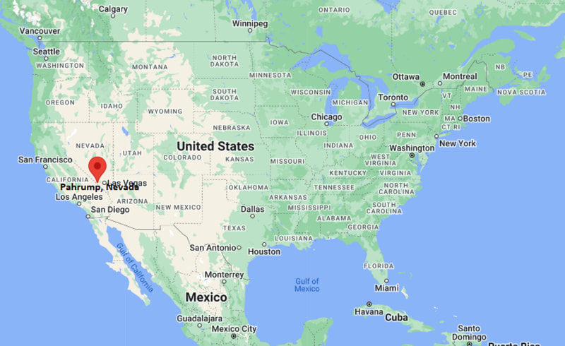
Pahrump Map, Nevada, USA
Where is Pahrump?: The Google Map showing the location of Pahrump in the U.S. state of Nevada.
Where is Pahrump Located?
Pahrump is a city located in theNye County of Nevada, United States. Pahrump lies between 43.0972174 Degrees North latitudes and 89.5042876 Degrees West longitudes. According to 2020 U.S.census, the population of Pahrump city is 44738 people and the city has a total area of 301.73 sq mi. The city has numerous parks and recreational facilities.
Most Viewed US Maps
| USA Sttae Map | USA Region Map | USA Road Map |
| USA County Map | Where is USA in World Map? | US ZIP Code Map |
| USA Time Zones Map | US State and Capitals Map | USA Physical Map |
Find 4,400+ U.S. Cities by State - Explore Their Locations and Get Detailed Information
Pahrump, Nevada Quick Facts
| Attribute | Details |
|---|---|
| City | Pahrump |
| County | Nye County |
| State | Nevada |
| State Capital | Carson City |
| US Region | Western United States (Mountain West) |
| Latitude | 36.2083° N |
| Longitude | 115.9839° W |
| Elevation | 2,697 ft (822 m) |
| Land Area | 364.19 sq mi |
| Water Area | 0.00 sq mi |
| Total Area | 364.19 sq mi |
| Population (2020 Census) | 44,738 |
| Population Density | Approximately 123 people per sq mi |
| ZIP Codes | 89041, 89048, 89060, 89061 |
| Area Code | 775 |
| Time Zone Standard | Pacific Standard Time (PST, UTC−8) |
| Time Zone Daylight | Pacific Daylight Time (PDT, UTC−7) |
| Currency | United States Dollar (USD) |
| FIPS Code | 32-53800 |
| Congressional District | Nevada's 2nd Congressional District |
Transportation and Connectivity in Pahrump, Nevada
| Category | Details |
|---|---|
| Airport Name | Calvada Meadows Airport |
| IATA Code | None (FAA: 74P) |
| Port | No commercial port |
| Major Highways | Nevada State Route 160, Nevada State Route 372 |
| Train/Amtrak Service | No passenger rail service; nearest Amtrak station at Las Vegas (Thruway connection) |
| Local Bus/Transit Service | Pahrump Valley Public Transportation and regional shuttle services |
- Nevada State Route 160 – The primary highway through Pahrump, connecting the community with Las Vegas to the east and Death Valley Junction, California, to the west.
- Nevada State Route 372 – Connects Pahrump with Shoshone, California, where it becomes California State Route 178.
Top Places to Visit in Pahrump, Nevada
| Landmark Name | Type |
|---|---|
| Spring Mountain Motor Resort & Country Club | Motorsports Facility |
| Pahrump Valley Winery | Winery |
| Sanders Family Winery | Winery |
| Mountain Falls Golf Club | Golf Course |
| Lake View Executive Golf Course | Golf Course |
| Discovery Park | Park |
| Pahrump Nugget Casino | Casino |
| Death Valley National Park (Eastern Entrance) | National Park |
| Ash Meadows National Wildlife Refuge | Wildlife Refuge |
| Pahrump Valley Museum | Museum |
Driving Distances from Pahrump, Nevada to Nearby Cities
| City | State | Distance (mi) | Approx. Drive Time |
|---|---|---|---|
| Las Vegas | Nevada | 63 | 1 hour 15 minutes |
| Henderson | Nevada | 72 | 1 hour 25 minutes |
| North Las Vegas | Nevada | 67 | 1 hour 20 minutes |
| Boulder City | Nevada | 85 | 1 hour 40 minutes |
| Shoshone | California | 31 | 35 minutes |
| Beatty | Nevada | 70 | 1 hour 20 minutes |
| Mesquite | Nevada | 144 | 2 hours 30 minutes |
| Kingman | Arizona | 168 | 2 hours 50 minutes |
| Baker | California | 103 | 1 hour 45 minutes |
| St. George | Utah | 181 | 3 hours |
Colleges and Universities in Pahrump, Nevada
| Institution Name | Type | Level | Notable For |
|---|---|---|---|
| Great Basin College – Pahrump Center | Public | Community College | Career and transfer education |
| Nevada State University – Pahrump Campus | Public | University | Teacher education and bachelor's programs |
| College of Southern Nevada – Pahrump Training Center | Public | Community College | Workforce development courses |
| Nye County School District | Public | K–12 District | Primary and secondary education |
Waterbodies in Pahrump, Nevada
Pahrump Valley, Manse Spring, Crystal Reservoir, Carson Slough, Ash Meadows, Amargosa River, Fairbanks Spring, Point of Rocks Spring, Longstreet Spring, Devil's Hole
Stadiums in Pahrump
Pahrump Valley High School Stadium, Ian Deutch Memorial Park Sports Complex, Petrack Park Sports Fields, Mountain Falls Golf Club, Lake View Executive Golf Course, Spring Mountain Motor Resort Karting Circuit
Pahrump, Nevada — Key Historical Facts
- Pahrump was originally home to Native American communities before becoming a ranching and farming settlement supported by natural springs in the nineteenth century.
- The town remained a small agricultural community for much of its history until improved highways encouraged residential growth in the late twentieth century.
- Pahrump developed into a popular destination for retirees and commuters seeking a quieter lifestyle within driving distance of Las Vegas.
- The community has become known for its vineyards and wineries, an uncommon feature in the Mojave Desert region of Nevada.
- Today, Pahrump serves as a gateway to Death Valley National Park and Ash Meadows National Wildlife Refuge, making tourism an important part of the local economy.
References
- Nye County Government
- U.S. Census Bureau
- Great Basin College
- Death Valley National Park
- Ash Meadows National Wildlife Refuge
More Nevada Maps & Info
- Where is Battle Mountain
- Where is Boulder City
- Where is Carlin
- Where is Carson City
- Where is Cold Springs
- Where is Dayton
- Where is Elko
- Where is Ely
- Where is Enterprise
- Where is Fallon
- Where is Fernley
- Where is Gardnerville
- Where is Gardnerville Ranchos
- Where is Golden Valley
- Where is Hawthorne
- Where is Incline Village
- Where is Indian Hills
- Where is Johnson Lane
- Where is Kingsbury
- Where is Laughlin
- Where is Lemmon Valley
- Where is Lovelock
- Where is Mesquite
- Where is Minden
- Where is Moapa Valley
- Where is Nellis AFB
- Where is Pahrump
- Where is Silver Springs
- Where is Smith Valley
- Where is Spanish Springs
- Where is Sparks
- Where is Spring Creek
- Where is Spring Valley
- Where is Stagecoach
- Where is Summerlin South
- Where is Sun Valley
- Where is Sunrise Manor
- Where is Tonopah
- Where is Topaz Ranch Estates
- Where is Washoe Valley
- Where is West Wendover
- Where is Whitney
- Where is Winchester
- Where is Winnemucca
- Where is Yerington