
Where is Summerlin South Located? - Summerlin South is a city located in the Clark County of Nevada, United States. Summerlin South lies between 42.5530753 Degrees North latitudes and 87.9334118 Degrees West longitudes.
Location Map of Summerlin South, Nevada
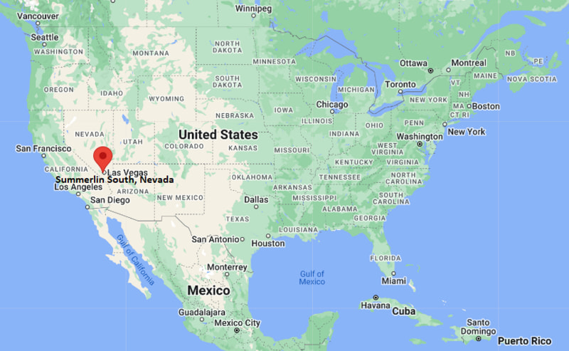
Summerlin South Map, Nevada, USA
Where is Summerlin South?: The Google Map showing the location of Summerlin South in the U.S. state of Nevada.
Where is Summerlin South Located?
Summerlin South is a city located in the Clark County of Nevada, United States. Summerlin South lies between 42.5530753 Degrees North latitudes and 87.9334118 Degrees West longitudes. According to 2020 U.S.census, the population of Summerlin South city is 30744 people and the city has a total area of 9.69 sq mi. The city has numerous parks and recreational facilities.
Most Viewed US Maps
| USA Map | USA Region Map | USA Road Map |
| USA County Map | Where is USA in World Map? | US ZIP Code Map |
| USA Time Zones Map | US State and Capitals Map | USA Physical Map |
Summerlin South, Nevada Quick Facts
| Attribute | Details |
|---|---|
| Community | Summerlin South |
| County | Clark County |
| State | Nevada |
| State Capital | Carson City |
| US Region | Western United States |
| Latitude | 36.0949° N |
| Longitude | 115.3228° W |
| Elevation | Approximately 3,000 ft (914 m) |
| Land Area (sq mi) | 9.69 |
| Water Area (sq mi) | 0.00 |
| Total Area (sq mi) | 9.69 |
| Population (2020 Census) | 30,744 |
| Population Density (per sq mi) | 3,174.4 |
| ZIP Code | 89135 |
| Area Codes | 702, 725 |
| Time Zone Standard | Pacific Standard Time (PST), UTC−8 |
| Time Zone Daylight | Pacific Daylight Time (PDT), UTC−7 |
| Currency | United States Dollar (USD) |
| FIPS Code | 3270900 |
| Congressional District | 3rd Congressional District |
Transportation and Connectivity in Summerlin South
| Transportation Feature | Details |
|---|---|
| Airport Name | Harry Reid International Airport provides major commercial air service. |
| IATA Code | LAS |
| Port | No direct port access; regional freight connections are available through Las Vegas transportation networks. |
| Major Highways | Interstate 215, Clark County 215 Beltway, Charleston Boulevard, and Sahara Avenue provide regional connections. |
| Train/Amtrak Service | Passenger rail service is available from Las Vegas-area transportation facilities. |
| Local Bus/Transit Service | Regional transportation services are provided by the Regional Transportation Commission of Southern Nevada. |
- Summerlin South is a census-designated place located in Clark County, Nevada.
- The community is located on the western edge of the Las Vegas Valley near the Red Rock Canyon area.
- Summerlin South is part of the larger Summerlin master-planned community and is known for parks, trails, neighborhoods, and desert landscapes.
- The area provides easy access to outdoor recreation, including nearby Red Rock Canyon National Conservation Area.
Top Places to Visit in Summerlin South, Nevada
| Landmark Name | Type |
|---|---|
| Red Rock Canyon National Conservation Area | National Conservation Area |
| Downtown Summerlin | Shopping and Entertainment District |
| Paseos Park | Community Park |
| South Tower Park | Public Park |
| Cottonwood Canyon | Natural Area |
| The Ridges | Residential and Scenic Area |
| Las Vegas Ballpark | Sports Stadium |
| Trails at Summerlin | Outdoor Recreation Area |
| Wetlands Park and Nature Areas | Nature Recreation |
| Spring Mountain Ranch State Park | State Park |
Driving Distances from Summerlin South, Nevada to Nearby Cities
| City | State | Distance (mi) | Approx. Drive Time |
|---|---|---|---|
| Las Vegas | Nevada | 15 | 25 min |
| Henderson | Nevada | 30 | 40 min |
| North Las Vegas | Nevada | 25 | 35 min |
| Boulder City | Nevada | 45 | 55 min |
| Mesquite | Nevada | 120 | 1 hr 45 min |
| St. George | Utah | 125 | 2 hr |
| Laughlin | Nevada | 100 | 1 hr 45 min |
| Kingman | Arizona | 115 | 1 hr 50 min |
| Los Angeles | California | 270 | 4 hr |
| Phoenix | Arizona | 300 | 4 hr 30 min |
Colleges and Universities near Summerlin South, Nevada
| Institution Name | Type | Level | Notable For |
|---|---|---|---|
| College of Southern Nevada | Public | Community College | Career training, technology, healthcare, and transfer programs |
| University of Nevada, Las Vegas | Public | University | Hospitality, business, engineering, law, and research programs |
| Roseman University of Health Sciences | Private | University | Healthcare education, pharmacy, nursing, and dental programs |
| Nevada State University | Public | University | Education, nursing, business, and professional programs |
| Touro University Nevada | Private | University | Medicine, health sciences, and healthcare education |
Waterbodies near Summerlin South, Nevada
Lake Mead, Colorado River, Las Vegas Wash, and nearby desert drainage waterways
Golf Courses near Summerlin South, Nevada
TPC Las Vegas, Bear's Best Las Vegas, Siena Golf Club, Arroyo Golf Club, and nearby Las Vegas golf facilities
Key Landmarks and Places to Visit in Summerlin South, Nevada
| Landmark Name | Type |
|---|---|
| Red Rock Canyon National Conservation Area | National Conservation Area |
| Downtown Summerlin | Shopping and Entertainment District |
| Las Vegas Ballpark | Sports Stadium |
| Paseos Park | Community Park |
| South Tower Park | Public Park |
| Spring Mountain Ranch State Park | State Park |
| Summerlin Trail System | Outdoor Recreation Area |
| The Ridges | Scenic Residential Area |
| Cottonwood Canyon | Natural Area |
| Red Rock Casino Resort Area | Entertainment District |
Waterbodies near Summerlin South, Nevada
Lake Mead, Colorado River, Las Vegas Wash, and nearby desert drainage waterways
Golf Courses near Summerlin South, Nevada
TPC Las Vegas, Bear's Best Las Vegas, Siena Golf Club, Arroyo Golf Club, and nearby Las Vegas golf facilities
Summerlin South, Nevada — Key Historical Facts
- Summerlin South was developed as part of the larger Summerlin master-planned community beginning in the late 20th century.
- The community was named after Howard Hughes' grandmother, Jean Amelia Summerlin, whose family history is connected to the development of the area.
- The area was transformed from desert land into a planned residential community with parks, schools, trails, and commercial areas.
- Summerlin South is located near Red Rock Canyon, an area known for its dramatic sandstone formations and outdoor recreation.
- Today, Summerlin South is recognized for its planned neighborhoods, recreational amenities, and proximity to Las Vegas attractions.
References
- Clark County Government
- Summerlin Official Community Website
- U.S. Census Bureau
- Nevada Tourism
- Red Rock Canyon National Conservation Area
- University of Nevada, Las Vegas
More Nevada Maps & Info
- Where is Battle Mountain
- Where is Boulder City
- Where is Carlin
- Where is Carson City
- Where is Cold Springs
- Where is Dayton
- Where is Elko
- Where is Ely
- Where is Enterprise
- Where is Fallon
- Where is Fernley
- Where is Gardnerville
- Where is Gardnerville Ranchos
- Where is Golden Valley
- Where is Hawthorne
- Where is Incline Village
- Where is Indian Hills
- Where is Johnson Lane
- Where is Kingsbury
- Where is Laughlin
- Where is Lemmon Valley
- Where is Lovelock
- Where is Mesquite
- Where is Minden
- Where is Moapa Valley
- Where is Nellis AFB
- Where is Pahrump
- Where is Silver Springs
- Where is Smith Valley
- Where is Spanish Springs
- Where is Sparks
- Where is Spring Creek
- Where is Spring Valley
- Where is Stagecoach
- Where is Summerlin South
- Where is Sun Valley
- Where is Sunrise Manor
- Where is Tonopah
- Where is Topaz Ranch Estates
- Where is Washoe Valley
- Where is West Wendover
- Where is Whitney
- Where is Winchester
- Where is Winnemucca
- Where is Yerington
