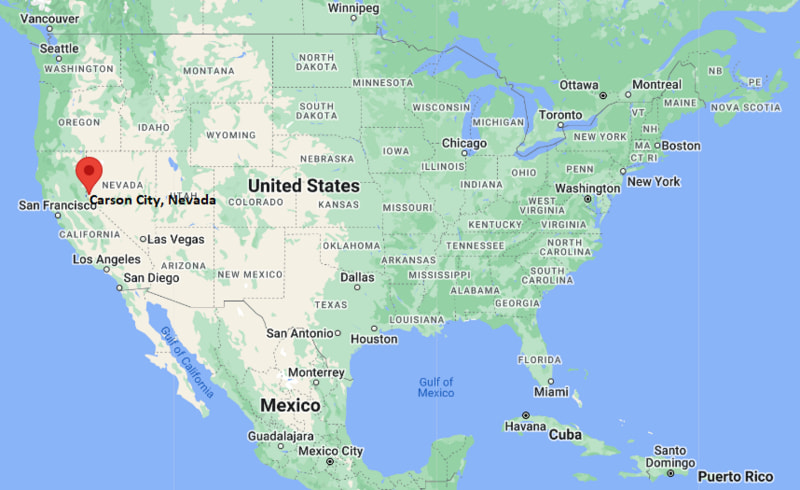
Where is Carson City Located? - Carson City is a city located in the None County of Nevada, United States. Carson City lies between 44.5235792 Degrees North latitudes and 89.574563 Degrees West longitudes.
Location Map of Carson City, Nevada
Carson City Map, Nevada, USA
Where is Carson City?: The Google Map showing the location of Carson City in the U.S. state of Nevada.
Where is Carson City Located?
Carson City is a city located in the None County of Nevada, United States. Carson City lies between 44.5235792 Degrees North latitudes and 89.574563 Degrees West longitudes. According to 2020 U.S.census, the population of Carson City city is 58639 people and the city has a total area of 144.66 sq mi. The city has numerous parks and recreational facilities.
Carson City (Independent Consolidated Municipality)
State
Nevada
State Capital
Carson City
US Region
West
Latitude
39.1638° N
Longitude
119.7674° W
Elevation
4,687 ft (1,429 m)
Land Area
143.40 sq mi
Water Area
0.58 sq mi
Total Area
143.98 sq mi
Population (2020 Census)
58,639
Population Density
409 per sq mi
ZIP Codes
89701, 89703, 89705, 89706, 89721
Area Code
775
Time Zone Standard
Pacific Standard Time (PST, UTC-8)
Time Zone Daylight
Pacific Daylight Time (PDT, UTC-7)
Currency
US Dollar (USD)
FIPS Code
32-13100
Congressional District
2nd Congressional District
Nearby Cities and Communities to Carson City, Nevada
Minden, Nevada - 16 mi
Gardnerville, Nevada - 19 mi
Virginia City, Nevada - 17 mi
Reno, Nevada - 31 mi
Incline Village, Nevada - 27 mi
South Lake Tahoe, California - 31 mi
Dayton, Nevada - 15 mi
Fernley, Nevada - 60 mi
Truckee, California - 49 mi
Sacramento, California - 134 mi
Carson City, Nevada Climate and Weather Overview
Month
Avg High (°F)
Avg Low (°F)
Avg Rainfall (in)
January
45
21
1.1
April
63
34
0.8
July
91
52
0.3
October
69
37
0.6
Annual
67
37
10.4
Climate Attribute
Details
Climate Classification (Köppen)
Cold Semi-Arid (BSk)
Annual Rainfall
About 10.4 in
Annual Sunshine Days
About 253 days
Hurricane/Tornado Risk
No hurricane risk and very low tornado risk
Snowfall
About 22 in annually
Driving Distances from Carson City, Nevada
City
State
Distance (mi)
Approx. Drive Time
Dayton
Nevada
15
20 min
Minden
Nevada
16
20 min
Virginia City
Nevada
17
30 min
Gardnerville
Nevada
19
25 min
Incline Village
Nevada
27
40 min
Reno
Nevada
31
35 min
South Lake Tahoe
California
31
40 min
Truckee
California
49
1 hr
Fernley
Nevada
60
1 hr
Sacramento
California
134
2 hr 20 min
Transportation and Connectivity in Carson City, Nevada
Transportation
Details
Airport Name
Carson Airport
IATA Code
CSN
Port
No commercial port
Major Highways
U.S. Highway 50, U.S. Highway 395, Interstate 580, Nevada State Route 28
Train/Amtrak Service
No passenger rail service; nearest Amtrak station in Reno
Local Bus/Transit Service
Jump Around Carson (JAC) Transit
Interstate 580 and U.S. Highways 50 and 395 connect Carson City with Reno, Lake Tahoe, and southern Nevada.
Carson Airport supports general aviation, business aircraft, and government operations.
Reno-Tahoe International Airport, about 30 miles north, provides extensive domestic flight service.
Jump Around Carson (JAC) Transit offers public bus service throughout the city.
As Nevada's capital city, Carson City serves as the state's political center while supporting tourism, government services, outdoor recreation, and regional commerce.
Key Landmarks and Places to Visit in Carson City, Nevada
Landmark Name
Type
Nevada State Capitol
Historic Government Building
Nevada State Museum
History Museum
Nevada State Railroad Museum
Railroad Museum
Kit Carson Trail
Historic Walking Trail
Empire Ranch Golf Course
Golf Course
Lake Tahoe Nevada State Park
State Park
Washoe Lake State Park
State Park
Kings Canyon Waterfalls Trail
Hiking Trail
Bowers Mansion Regional Park
Historic Park
Children's Museum of Northern Nevada
Children's Museum
Colleges and Universities in and near Carson City, Nevada
Institution Name
Type
Level
Notable For
Western Nevada College
Public
Community College
Associate degrees, workforce training, and transfer programs
University of Nevada, Reno
Public
University
Research, engineering, medicine, and business
Sierra Nevada University
Private
University
Business, environmental science, and liberal arts
Truckee Meadows Community College
Public
Community College
Technical education and university transfer programs
Lake Tahoe Community College
Public
Community College
Transfer education and career training
Waterbodies in Carson City, Nevada
Carson River, Washoe Lake, Marlette Lake, Hobart Reservoir, Lake Tahoe, Spooner Lake, Clear Creek, Kings Canyon Creek
Golf Courses in and near Carson City, Nevada
Empire Ranch Golf Course, Silver Oak Golf Course, Eagle Valley Golf Course, Genoa Lakes Golf Club, Toiyabe Golf Club, Dayton Valley Golf Club, Lake Tahoe Golf Course, Edgewood Tahoe Golf Course
Carson City, Nevada - Key Historical Facts
Carson City was founded in 1858 and named after the famous frontiersman Kit Carson, who explored much of the American West.
The discovery of the nearby Comstock Lode in 1859 brought rapid growth as the city became a center for mining, commerce, and transportation.
When Nevada achieved statehood in 1864, Carson City was selected as the state capital because of its central role in government and regional development.
The Virginia and Truckee Railroad connected Carson City with Virginia City and Reno, supporting mining and economic expansion throughout the late nineteenth century.
Government services, tourism, and outdoor recreation gradually became major contributors to the local economy as mining declined.
Today, Carson City is known for its historic downtown, state government institutions, museums, access to Lake Tahoe and the Sierra Nevada, and year-round recreational opportunities.