
Fairfield is a city in central Alabama and part of the Birmingham metropolitan area. It lies about 7 miles southwest of downtown Birmingham in Jefferson County. Founded as a planned steel company town in the early 20th century, Fairfield is known for Miles College, its historic neighborhoods, industrial heritage, and close connection to the Birmingham area.
Location Map of Fairfield, Jefferson County, Alabama
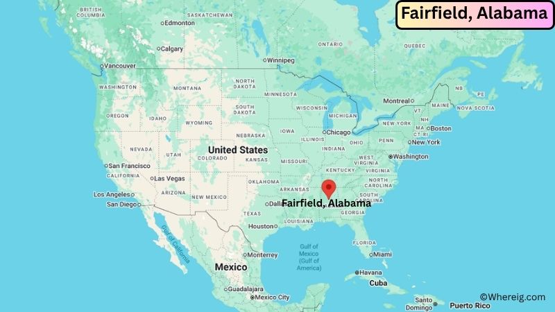
About Map: The map shows the location of Fairfield in Jefferson County, in the U.S. state of Alabama.
Fairfield Map, Alabama
About Fairfield Map: The Google Map highlights the location of Fairfield in Jefferson County, Alabama. Use the zoom, satellite, and street-view options to explore the city's neighborhoods, roads, and nearby places.
Where is Fairfield Located?
Fairfield is a city located in Jefferson County, Alabama, the United States. It lies immediately southwest of Birmingham, about 7 miles from downtown Birmingham and roughly 6 miles east of Bessemer. Fairfield is positioned at approximately 33.475° North latitude and 86.919° West longitude. The city covers about 3.46 square miles, or 8.96 square kilometers, of land. The 2020 Census recorded exactly 10,000 residents, while the latest available Census estimate was 9,524 in 2024. Fairfield stands at roughly 560 feet above sea level. Miles College is one of the city's best-known landmarks and is a historically Black college founded in 1898. Fairfield was founded by U.S. Steel in 1910 as a planned company town and incorporated in 1919. Its historic residential streets, former industrial buildings, and connection to the steel industry remain important parts of its identity.
Most Viewed US Maps
| USA Sttae Map | USA Region Map | USA Road Map |
| USA County Map | Where is USA in World Map? | US ZIP Code Map |
| USA Time Zones Map | US State and Capitals Map | USA Physical Map |
Find 4,400+ U.S. Cities by State - Explore Their Locations and Get Detailed Information
Fairfield City Facts
| City | Fairfield |
|---|---|
| State | Alabama |
| County | Jefferson County |
| Country | United States |
| Region | Central Alabama, Birmingham Metropolitan Area |
| Incorporated | January 1, 1919 |
| Founded | 1910 |
| Total Area | 3.46 sq mi (8.96 sq km) |
| Land Area | 3.46 sq mi (8.96 sq km) |
| Water Area | 0 sq mi (0 sq km) |
| Elevation | 560 ft (171 m) |
| Population (2023 estimate) | 9,700 |
| Population (2020 Census) | 10,000 |
| Population Density | 2,890.2 people per sq mi |
| Time Zone | Central Time (CST/CDT) |
| ZIP Codes | 35064 |
| Area Code | 205, 659 |
| Major Highways | Interstate 20/59, U.S. Route 11, Alabama State Route 5 |
| Public Transit | MAX Transit and Birmingham-area regional transportation services |
| Major Attractions | Miles College, Fairfield Historic District, Flintridge Building, Fairfield City Park, Birmingham attractions |
| Official Website | https://cityoffairfieldal.org/ |
Distance from Fairfield, AL to Nearby Cities
- Midfield, AL – 2 miles (3 km)
- Homewood, AL – 7 miles (11 km)
- Birmingham, AL – 7 miles (11 km)
- Bessemer, AL – 8 miles (13 km)
- Hoover, AL – 11 miles (18 km)
- Vestavia Hills, AL – 12 miles (19 km)
- Mountain Brook, AL – 12 miles (19 km)
- Homewood, AL – 7 miles (11 km)
- Irondale, AL – 15 miles (24 km)
- Trussville, AL – 20 miles (32 km)
- Gardendale, AL – 14 miles (23 km)
- Alabaster, AL – 25 miles (40 km)
- Pleasant Grove, AL – 6 miles (10 km)
- Hueytown, AL – 5 miles (8 km)
- Fultondale, AL – 13 miles (21 km)
- Tuscaloosa, AL – 55 miles (89 km)
- Montgomery, AL – 95 miles (153 km)
- Huntsville, AL – 105 miles (169 km)
Top Attractions in Fairfield
- Miles College – A historically Black college founded in 1898 and one of Fairfield's most important educational and cultural institutions.
- Fairfield Historic District – A historic residential and commercial area reflecting the city's origins as a planned steel company town.
- Flintridge Building – A notable mid-century building associated with the Tennessee Coal, Iron and Railroad Company and Fairfield's industrial history.
- Fairfield City Park – A community recreation area with athletic fields, tennis courts, basketball facilities, playgrounds, and picnic space.
- Fairfield Civic Plaza – A historic civic area associated with the original planned design of the city.
- Fairfield City Hall – A historic 1945 municipal building that remains an important part of Fairfield's civic heritage.
- Parham Apothecary Building – A historic commercial building dating from the 1920s and listed on the National Register of Historic Places.
- Birmingham Civil Rights District – A major Birmingham historic area with museums, landmarks, and sites connected to the American civil rights movement.
- Alabama Sports Hall of Fame – A Birmingham attraction honoring notable athletes and sports figures from Alabama.
- Sloss Furnaces National Historic Landmark – A preserved Birmingham industrial site documenting the region's historic iron and steel industry.
Airports Near Fairfield
- Birmingham-Shuttlesworth International Airport (BHM) – 13 miles
- Bessemer Municipal Airport (EKY) – 13 miles
- Tuscaloosa National Airport (TCL) – 57 miles
- Shelby County Airport (EET) – 35 miles
- Montgomery Regional Airport (MGM) – 105 miles
Sources:
Population and area data sourced from the United States Census Bureau (2020 Census). General city information referenced from the official City of Fairfield website and local government records.
Alabama Related Links
- Where is Alabaster
- Where is Albertville
- Where is Anniston
- Where is Athens
- Where is Auburn
- Where is Bessemer
- Where is Calera
- Where is Center Point
- Where is Chelsea
- Where is Cullman
- Where is Daphne
- Where is Decatur
- Where is Dothan
- Where is Enterprise
- Where is Fairhope
- Where is Florence
- Where is Foley
- Where is Fort Payne
- Where is Gadsden
- Where is Gardendale
- Where is Gulf Shores
- Where is Hartselle
- Where is Helena
- Where is Homewood
- Where is Hoover
- Where is Hueytown
- Where is Huntsville
- Where is Millbrook
- Where is Mobile
- Where is Mountain Brook
- Where is Muscle Shoals
- Where is Northport
- Where is Opelika
- Where is Oxford
- Where is Pelham
- Where is Phenix City
- Where is Prattville
- Where is Prichard
- Where is Saraland
- Where is Scottsboro
- Where is Selma
- Where is Talladega
- Where is Tillmans Corner
- Where is Troy
- Where is Trussville
- Where is Tuscaloosa
- Where is Vestavia Hills