
Fultondale is a city in central Alabama and part of the Birmingham metropolitan area. It is about 8 miles north of downtown Birmingham in Jefferson County. The city is known for its convenient location along Interstate 65, nearby Black Creek Park, and easy access to Birmingham's major attractions, while its northern setting connects the community with Gardendale and other northern suburbs.
Location Map of Fultondale, Jefferson County, Alabama
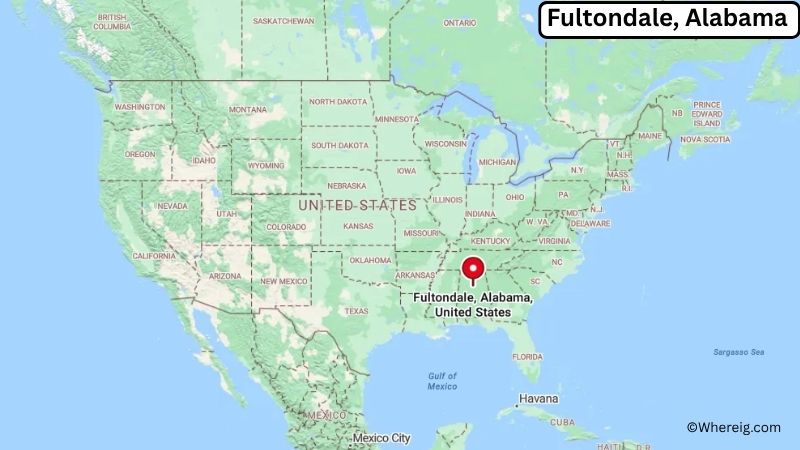
About Map: The map shows the location of Fultondale in Jefferson County, in the U.S. state of Alabama.
Fultondale Map, Alabama
About Fultondale Map: The Google Map highlights the location of Fultondale in Jefferson County, Alabama. Use the zoom, satellite, and street-view options to explore the city's neighborhoods, roads, and nearby places.
Where is Fultondale Located?
Fultondale is a city located in Jefferson County, Alabama, the United States. It lies in central Alabama just north of Birmingham, about 8 miles north of downtown Birmingham, 4 miles south of Gardendale, and roughly 15 miles southwest of Center Point. Fultondale is positioned at approximately 33.605° North latitude and 86.793° West longitude. The city covers about 12.37 square miles, or 32.04 square kilometers, including land and water. The 2020 Census recorded 9,264 residents, while recent estimates place the population at about 9,000. Fultondale stands at an elevation of roughly 550 feet above sea level. The community developed as a residential and transportation center north of Birmingham and was incorporated as a city in 1947. Its location along Interstate 65 has played an important role in its growth and provides direct access to Birmingham and communities throughout central Alabama. The area has rolling hills, wooded landscapes, creeks, and developed commercial corridors. Nearby Black Creek Park provides opportunities for walking, picnicking, and outdoor recreation. Birmingham's downtown attractions, including the Birmingham Civil Rights Institute, Railroad Park, and Barber Vintage Motorsports Museum, are within a short drive. Fultondale's location also places it near the Sloss Furnaces National Historic Landmark and the southern foothills of the Appalachian region.
Most Viewed US Maps
| USA Sttae Map | USA Region Map | USA Road Map |
| USA County Map | Where is USA in World Map? | US ZIP Code Map |
| USA Time Zones Map | US State and Capitals Map | USA Physical Map |
Find 4,400+ U.S. Cities by State - Explore Their Locations and Get Detailed Information
Fultondale City Facts
| City | Fultondale |
|---|---|
| State | Alabama |
| County | Jefferson County |
| Country | United States |
| Region | Central Alabama, Birmingham Metropolitan Area |
| Incorporated | 1947 |
| Founded | Early 20th century |
| Total Area | 12.37 sq mi (32.04 sq km) |
| Land Area | 12.34 sq mi (31.96 sq km) |
| Water Area | 0.03 sq mi (0.08 sq km) |
| Elevation | 550 ft (168 m) |
| Population (2023 estimate) | About 9,000 |
| Population (2020 Census) | 9,264 |
| Population Density | 750.7 people per sq mi |
| Time Zone | Central Time (CST/CDT) |
| ZIP Codes | 35068, 35217 |
| Area Code | 205, 659 |
| Major Highways | Interstate 65, U.S. Highway 31, Alabama State Route 79 |
| Public Transit | MAX Transit |
| Major Attractions | Black Creek Park, Sloss Furnaces National Historic Landmark, Birmingham Civil Rights Institute, Railroad Park, Barber Vintage Motorsports Museum |
| Official Website | https://www.fultondaleal.gov/ |
Distance from Fultondale, AL to Nearby Cities
- Gardendale, AL – 4 miles (6 km)
- Birmingham, AL – 8 miles (13 km)
- Center Point, AL – 10 miles (16 km)
- Mountain Brook, AL – 12 miles (19 km)
- Homewood, AL – 12 miles (19 km)
- Irondale, AL – 12 miles (19 km)
- Trussville, AL – 15 miles (24 km)
- Hoover, AL – 20 miles (32 km)
- Vestavia Hills, AL – 18 miles (29 km)
- Leeds, AL – 20 miles (32 km)
- Alabaster, AL – 35 miles (56 km)
- Pelham, AL – 30 miles (48 km)
- Clanton, AL – 55 miles (89 km)
- Tuscaloosa, AL – 60 miles (97 km)
- Anniston, AL – 65 miles (105 km)
- Gadsden, AL – 60 miles (97 km)
- Montgomery, AL – 95 miles (153 km)
- Huntsville, AL – 100 miles (161 km)
Top Attractions in Fultondale
- Black Creek Park – A local outdoor recreation area with walking trails, wooded scenery, picnic areas, and open space.
- Sloss Furnaces National Historic Landmark – A preserved 19th-century industrial site in Birmingham that documents the city's iron-making history.
- Birmingham Civil Rights Institute – A major Birmingham museum documenting the history of the civil rights movement and its impact on the city and nation.
- Railroad Park – A large downtown Birmingham park with walking paths, lawns, gardens, playgrounds, and views of the city skyline.
- Barber Vintage Motorsports Museum – A large motorcycle and motorsports museum near Birmingham featuring an extensive collection of historic motorcycles and racing exhibits.
- Birmingham Museum of Art – A major regional art museum with collections spanning American, European, Asian, African, and contemporary art.
- Vulcan Park and Museum – A Birmingham landmark centered on the world's largest cast-iron statue, with panoramic views of the city.
- Birmingham Botanical Gardens – A large public garden featuring themed landscapes, walking paths, native plants, and educational programs.
- Red Mountain Park – A large Birmingham park with hiking trails, overlooks, zip lines, and historic mining features.
- Ruffner Mountain Nature Preserve – A major urban nature preserve east of Birmingham with hiking trails, forests, wildlife, and views across the metropolitan area.
Airports Near Fultondale
- Birmingham-Shuttlesworth International Airport (BHM) – 10 miles
- Roberts Field Airport (KJFX) – 25 miles
- St. Clair County Airport (PLR) – 35 miles
- Tuscaloosa National Airport (TCL) – 70 miles
- Huntsville International Airport (HSV) – 110 miles
Sources:
Population and area data sourced from the United States Census Bureau (2020 Census). General city information referenced from the official City of Fultondale website and local government records.
Alabama Related Links
- Where is Alabaster
- Where is Albertville
- Where is Anniston
- Where is Athens
- Where is Auburn
- Where is Bessemer
- Where is Calera
- Where is Center Point
- Where is Chelsea
- Where is Cullman
- Where is Daphne
- Where is Decatur
- Where is Dothan
- Where is Enterprise
- Where is Fairhope
- Where is Florence
- Where is Foley
- Where is Fort Payne
- Where is Gadsden
- Where is Gardendale
- Where is Gulf Shores
- Where is Hartselle
- Where is Helena
- Where is Homewood
- Where is Hoover
- Where is Hueytown
- Where is Huntsville
- Where is Millbrook
- Where is Mobile
- Where is Mountain Brook
- Where is Muscle Shoals
- Where is Northport
- Where is Opelika
- Where is Oxford
- Where is Pelham
- Where is Phenix City
- Where is Prattville
- Where is Prichard
- Where is Saraland
- Where is Scottsboro
- Where is Selma
- Where is Talladega
- Where is Tillmans Corner
- Where is Troy
- Where is Trussville
- Where is Tuscaloosa
- Where is Vestavia Hills