
Grand Haven is a waterfront city on Michigan's western shore, located in Ottawa County along Lake Michigan. It is about 30 miles west of Grand Rapids and near the mouth of the Grand River. The city is known for its sandy beaches, historic lighthouse, waterfront boardwalk, musical fountain, and harbor that connects the Grand River with Lake Michigan.
Location Map of Grand Haven, Ottawa County, Michigan
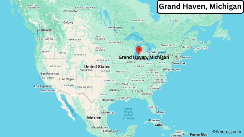
About Map: The map shows the location of Grand Haven in Ottawa County, in the U.S. state of Michigan.
Grand Haven Map, Michigan
About Grand Haven Map: The Google Map highlights the location of Grand Haven in Ottawa County, Michigan. Use the zoom, satellite, and street-view options to explore the city's neighborhoods, roads, and nearby places.
Where is Grand Haven Located?
Grand Haven is a city located in Ottawa County, Michigan, the United States. It sits on the eastern shore of Lake Michigan at the mouth of the Grand River, about 30 miles west of Grand Rapids and roughly 20 miles north of Holland. Grand Haven is part of the Grand Rapids metropolitan area and is connected to nearby communities by U.S. Route 31 and other regional roads. The city is located at approximately 43.063° North latitude and 86.228° West longitude. The 2020 Census recorded 10,412 residents. Grand Haven covers about 7.88 square miles, or 20.41 square kilometers, including land and water. The city was settled in the 1830s and became an important port and lumber center along the Grand River. Today, Grand Haven's waterfront is its defining feature. The Grand Haven South Pierhead Lighthouse, Grand Haven State Park, and Musical Fountain are among the city's best-known attractions. Its beaches, harbor, trails, and historic downtown also draw visitors throughout the year.
Most Viewed US Maps
| USA Sttae Map | USA Region Map | USA Road Map |
| USA County Map | Where is USA in World Map? | US ZIP Code Map |
| USA Time Zones Map | US State and Capitals Map | USA Physical Map |
Find 4,400+ U.S. Cities by State - Explore Their Locations and Get Detailed Information
Grand Haven City Facts
| Fact | Details |
|---|---|
| City | Grand Haven |
| State | Michigan |
| County | Ottawa County |
| Country | United States |
| Region | West Michigan |
| Incorporated | 1867 |
| Founded | 1834 |
| Total Area | 7.88 sq mi (20.41 sq km) |
| Land Area | 5.28 sq mi (13.68 sq km) |
| Water Area | 2.60 sq mi (6.73 sq km) |
| Elevation | About 590 ft (180 m) |
| Population (2023 estimate) | About 10,500 |
| Population (2020 Census) | 10,412 |
| Population Density | About 1,972 people per sq mi |
| Time Zone | Eastern Time (ET) |
| ZIP Codes | 49417 |
| Area Code | 616 |
| Major Highways | U.S. Route 31, Interstate 96 |
| Public Transit | Macatawa Area Express and Harbor Transit |
| Major Attractions | Grand Haven State Park, Grand Haven Musical Fountain, Grand Haven Lighthouse, Grand Haven Boardwalk |
| Official Website | https://www.grandhaven.org/ |
Distance from Grand Haven, MI to Nearby Cities
- Spring Lake, MI – 3 miles (5 km)
- Ferrysburg, MI – 3 miles (5 km)
- Nunica, MI – 7 miles (11 km)
- Fruitport, MI – 10 miles (16 km)
- Holland, MI – 22 miles (35 km)
- Muskegon, MI – 13 miles (21 km)
- Zeeland, MI – 25 miles (40 km)
- Allendale, MI – 20 miles (32 km)
- Hudsonville, MI – 22 miles (35 km)
- Grand Rapids, MI – 30 miles (48 km)
- Wyoming, MI – 28 miles (45 km)
- Walker, MI – 27 miles (43 km)
- Kalamazoo, MI – 80 miles (129 km)
- Lansing, MI – 90 miles (145 km)
- South Bend, IN – 100 miles (161 km)
Top Attractions in Grand Haven
- Grand Haven State Park – A popular Lake Michigan park with a wide sandy beach, swimming area, and views of the Grand Haven channel.
- Grand Haven South Pierhead Lighthouse – A historic red lighthouse at the entrance to the Grand River channel, one of the city's most recognizable landmarks.
- Grand Haven Boardwalk – A waterfront walkway along the channel connecting the harbor area with the pier and lighthouse.
- Grand Haven Musical Fountain – A long-running waterfront attraction featuring synchronized water, lights, and music performances.
- Grand Haven Coast Guard Festival – An annual community event celebrating the city's connection with the United States Coast Guard.
- Grand Haven Lighthouse Museum – A museum preserving the maritime history of Grand Haven and the surrounding Lake Michigan coast.
- Pere Marquette Park – A nearby lakeshore park in Muskegon with beaches, dunes, trails, and Lake Michigan views.
- Rosy Mound Natural Area – A nearby Ottawa County natural area with wooded trails, dunes, and a Lake Michigan beach.
Airports Near Grand Haven
- Muskegon County Airport (MKG) – 10 miles
- Gerald R. Ford International Airport (GRR) – 45 miles
- West Michigan Regional Airport (BIV) – 35 miles
- Kalamazoo/Battle Creek International Airport (AZO) – 85 miles
- South Bend International Airport (SBN) – 105 miles
Sources:
Population and area data sourced from the United States Census Bureau (2020 Census). General city information referenced from the official Grand Haven city website and local government records.
Michigan Related Maps and Info
- Where is Allen Park
- Where is Allendale
- Where is Ann Arbor
- Where is Battle Creek
- Where is Bay City
- Where is Burton
- Where is Dearborn
- Where is Dearborn Heights
- Where is East Lansing
- Where is Eastpointe
- Where is Farmington Hills
- Where is Flint
- Where is Forest Hills
- Where is Garden City
- Where is Grand Rapids
- Where is Hamtramck
- Where is Holland
- Where is Holt
- Where is Inkster
- Where is Jackson
- Where is Kalamazoo
- Where is Kentwood
- Where is Lansing
- Where is Lincoln Park
- Where is Livonia
- Where is Madison Heights
- Where is Midland
- Where is Muskegon
- Where is Novi
- Where is Oak Park
- Where is Okemos
- Where is Pontiac
- Where is Port Huron
- Where is Portage
- Where is Rochester Hills
- Where is Romulus
- Where is Roseville
- Where is Royal Oak
- Where is Saginaw
- Where is Southfield
- Where is Southgate
- Where is St. Clair Shores
- Where is Sterling Heights
- Where is Taylor
- Where is Troy
- Where is Walker
- Where is Warren
- Where is Westland
- Where is Wyoming