
Where is Harrison Located? - Harrison is a city located in the Hudson County of New Jersey, United States. Harrison lies between 43.5009176 Degrees North latitudes and 70.4428286 Degrees West longitudes.
Location Map of Harrison, New Jersey
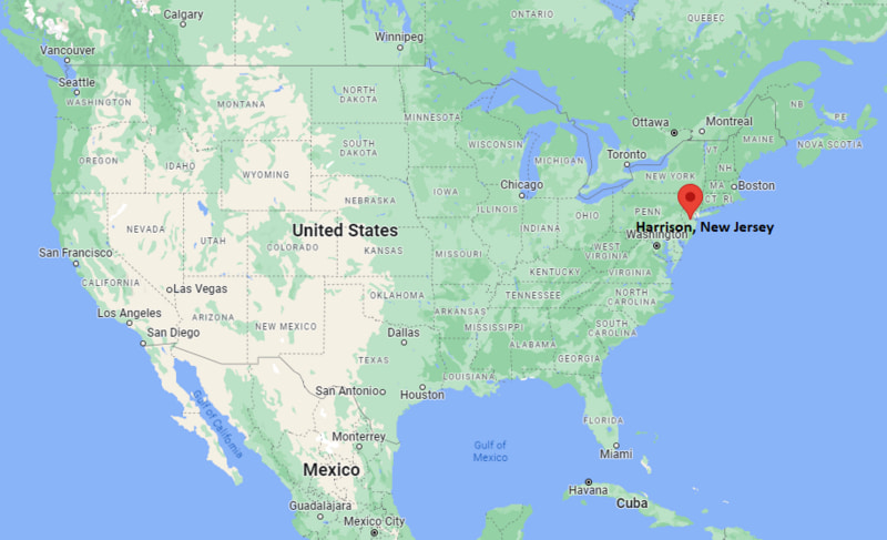
Harrison Map, New Jersey, USA
Where is Harrison?: The Google Map showing the location of Harrison in the U.S. state of New Jersey.
Where is Harrison Located?
Harrison is a city located in the Hudson County of New Jersey, United States. Harrison lies between 43.5009176 Degrees North latitudes and 70.4428286 Degrees West longitudes. According to 2020 U.S.census, the population of Harrison city is 19450 people and the city has a total area of 1.21 sq mi. The city has numerous parks and recreational facilities.
Most Viewed US Maps
| USA Sttae Map | USA Region Map | USA Road Map |
| USA County Map | Where is USA in World Map? | US ZIP Code Map |
| USA Time Zones Map | US State and Capitals Map | USA Physical Map |
Find 4,400+ U.S. Cities by State - Explore Their Locations and Get Detailed Information
Harrison, New Jersey Quick Facts
| Property | Information |
|---|---|
| Town | Harrison |
| County | Hudson County |
| State | New Jersey |
| State Capital | Trenton |
| US Region | Northeastern United States |
| Latitude | 40.7465°N |
| Longitude | 74.1563°W |
| Elevation | 23 ft (7 m) |
| Land Area | 1.29 sq mi |
| Water Area | 0.06 sq mi |
| Total Area | 1.35 sq mi |
| Population (latest Census year) | 19,450 (Census 2020) |
| Population Density | Approximately 15,080 per sq mi |
| ZIP Code | 07029 |
| Area Code | 973 |
| Time Zone Standard | Eastern Standard Time (EST, UTC−5) |
| Time Zone Daylight | Eastern Daylight Time (EDT, UTC−4) |
| Currency | US Dollar (USD) |
| FIPS Code | 34-29490 |
| Congressional District | New Jersey's 8th Congressional District |
Nearby Cities to Harrison, New Jersey
- Newark, New Jersey — 2 mi East
- Kearny, New Jersey — 2 mi North
- East Newark, New Jersey — 1 mi North
- East Orange, New Jersey — 5 mi Northwest
- Belleville, New Jersey — 5 mi North
- Jersey City, New Jersey — 10 mi East
- Elizabeth, New Jersey — 9 mi South
- Bloomfield, New Jersey — 7 mi North
- Union City, New Jersey — 11 mi Northeast
- New York, New York — 13 mi East
Driving Distances from Harrison, New Jersey
| City | State | Distance (mi) | Approx. Drive Time |
|---|---|---|---|
| Newark | New Jersey | 2 | 5 minutes |
| Kearny | New Jersey | 2 | 5 minutes |
| East Orange | New Jersey | 5 | 15 minutes |
| Jersey City | New Jersey | 10 | 20 minutes |
| Elizabeth | New Jersey | 9 | 20 minutes |
| New York | New York | 13 | 30 minutes |
| Paterson | New Jersey | 17 | 30 minutes |
| New Brunswick | New Jersey | 28 | 40 minutes |
| Morristown | New Jersey | 25 | 40 minutes |
| Trenton | New Jersey | 58 | 1 hour 5 minutes |
Transportation and Connectivity in Harrison, New Jersey
| Transportation | Details |
|---|---|
| Airport Name | Newark Liberty International Airport |
| IATA Code | EWR |
| Port | Port Newark–Elizabeth Marine Terminal |
| Major Highways | Interstate 280, U.S. Route 1/9, New Jersey Route 21, New Jersey Turnpike (nearby) |
| Train/Amtrak Service | PATH rapid transit; nearby Amtrak and NJ Transit at Newark Penn Station |
| Local Bus/Transit Service | NJ Transit bus service and PATH trains |
- PATH trains provide direct service between Harrison, Newark, Jersey City, and Lower Manhattan.
- Newark Penn Station, just across the Passaic River, offers Amtrak and NJ Transit rail connections throughout the Northeast Corridor.
- Interstate 280 and nearby U.S. Route 1/9 provide fast access to northern New Jersey and New York City.
- Newark Liberty International Airport is approximately 6 miles south and serves domestic and international destinations.
- Harrison's location within the New York metropolitan area makes it one of New Jersey's best-connected commuter communities.
What are top Places to Visit in Harrison, New Jersey
| Landmark Name | Type |
|---|---|
| Sports Illustrated Stadium | Soccer Stadium |
| West Hudson Park | County Park |
| Riverbend District | Mixed-use Development |
| Passaic River Waterfront | Scenic Riverfront |
| Newark Museum of Art | Art Museum |
| Branch Brook Park | Historic Park |
| New Jersey Performing Arts Center | Performing Arts Venue |
| Military Park | Urban Park |
| Red Bull Arena Plaza | Entertainment Area |
| Liberty State Park | State Park |
Colleges and Universities in Harrison, New Jersey
| Institution | Type | Level | Notable For |
|---|---|---|---|
| New Jersey Institute of Technology (NJIT) | Public | University | Engineering, computing, architecture, and research |
| Rutgers University–Newark | Public | University | Law, business, public affairs, and liberal arts |
| Essex County College | Public | Community College | Associate degrees and workforce education |
| Seton Hall University | Private | University | Business, law, diplomacy, and health sciences |
| Hudson County Community College | Public | Community College | Career training and university transfer programs |
Waterbodies in Harrison, New Jersey
Passaic River, Hackensack River, Newark Bay, Upper New York Bay, Hudson River, Arthur Kill, Newark Reservoir, Kearny Marsh, Mill Creek, Saddle River
Golf Courses in Harrison, New Jersey
Hendricks Field Golf Course, Weequahic Golf Course, Galloping Hill Golf Course, Francis A. Byrne Golf Course, Skyway Golf Course, Forest Hill Field Club, Essex County Country Club, Bayonne Golf Club
Harrison, New Jersey — Key Historical Facts
- Harrison was incorporated as a township in 1840 after being formed from portions of Lodi Township in Bergen County before becoming part of Hudson County.
- The town grew rapidly during the late nineteenth and early twentieth centuries as a manufacturing center, producing textiles, chemicals, machinery, and industrial goods.
- Its location along the Passaic River and extensive rail network helped establish Harrison as an important industrial hub within the New York metropolitan area.
- Beginning in the early 2000s, Harrison underwent major redevelopment with new residential neighborhoods, commercial projects, and the construction of Sports Illustrated Stadium, home of the New York Red Bulls.
- Today, Harrison is recognized for its transit-oriented development, thriving residential growth, professional soccer venue, and convenient access to Newark and New York City.
References
Other New Jersey Maps & Info
- Where is Atlantic City
- Where is Avenel
- Where is Bayonne
- Where is Bergenfield
- Where is Bridgeton
- Where is Camden
- Where is Carteret
- Where is Cliffside Park
- Where is Clifton
- Where is Colonia
- Where is Dover
- Where is Dumont
- Where is East Orange
- Where is Edgewater
- Where is Elizabeth
- Where is Elmwood Park
- Where is Englewood
- Where is Fair Lawn
- Where is Fairview
- Where is Fort Lee
- Where is Garfield
- Where is Glassboro
- Where is Hackensack
- Where is Harrison
- Where is Hawthorne
- Where is Highland Park
- Where is Hoboken
- Where is Iselin
- Where is Kearny
- Where is Lakewood
- Where is Linden
- Where is Lindenwold
- Where is Lodi
- Where is Long Branch
- Where is Metuchen
- Where is Millville
- Where is Morristown
- Where is New Brunswick
- Where is New Milford
- Where is North Arlington
- Where is North Plainfield
- Where is Ocean Acres
- Where is Old Bridge
- Where is Palisades Park
- Where is Paramus
- Where is Passaic
- Where is Paterson
- Where is Perth Amboy
- Where is Phillipsburg
- Where is Plainfield
- Where is Pleasantville
- Where is Point Pleasant
- Where is Princeton Meadows
- Where is Rahway
- Where is Ridgewood
- Where is Roselle
- Where is Rutherford
- Where is Sayreville
- Where is Secaucus
- Where is Somerset
- Where is South Plainfield
- Where is South River
- Where is Summit
- Where is Tenafly
- Where is Tinton Falls
- Where is Toms River
- Where is Trenton
- Where is Union City
- Where is Vineland
- Where is West New York
- Where is Westfield
- Where is Woodbridge