
Where is Pleasantville Located? - Pleasantville is a city located in the Atlantic County of New Jersey, United States. Pleasantville lies between 43.9140162 Degrees North latitudes and 69.9669961 Degrees West longitudes.
Location Map of Pleasantville, New Jersey
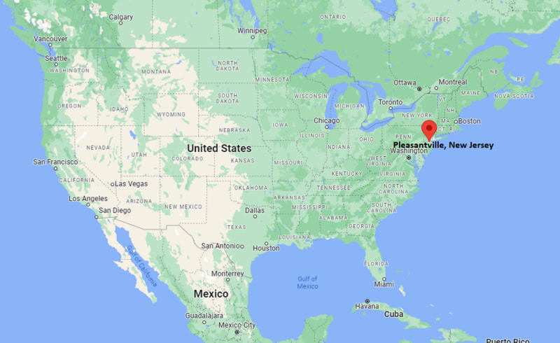
Pleasantville Map, New Jersey, USA
Where is Pleasantville?: The Google Map showing the location of Pleasantville in the U.S. state of New Jersey.
Where is Pleasantville Located?
Pleasantville is a city located in the Atlantic County of New Jersey, United States. Pleasantville lies between 43.9140162 Degrees North latitudes and 69.9669961 Degrees West longitudes. According to 2020 U.S.census, the population of Pleasantville city is 20629 people and the city has a total area of 5.72 sq mi. The city has numerous parks and recreational facilities.
Most Viewed US Maps
| USA Sttae Map | USA Region Map | USA Road Map |
| USA County Map | Where is USA in World Map? | US ZIP Code Map |
| USA Time Zones Map | US State and Capitals Map | USA Physical Map |
Find 4,400+ U.S. Cities by State - Explore Their Locations and Get Detailed Information
Pleasantville, New Jersey Quick Facts
| Attribute | Details |
|---|---|
| City | Pleasantville |
| County | Atlantic County |
| State | New Jersey |
| State Capital | Trenton |
| US Region | Northeastern United States (Middle Atlantic Region) |
| Latitude | 39.3898° N |
| Longitude | 74.5243° W |
| Elevation | 13 ft (4 m) |
| Land Area | 7.96 sq mi |
| Water Area | 0.71 sq mi |
| Total Area | 8.67 sq mi |
| Population (2020 Census) | 20,629 |
| Population Density | Approximately 2,591 people per sq mi |
| ZIP Codes | 08232 |
| Area Code | 609 |
| Time Zone Standard | Eastern Standard Time (EST, UTC−5) |
| Time Zone Daylight | Eastern Daylight Time (EDT, UTC−4) |
| Currency | United States Dollar (USD) |
| FIPS Code | 34-59070 |
| Congressional District | New Jersey's 2nd Congressional District |
Transportation and Connectivity in Pleasantville
| Category | Details |
|---|---|
| Airport Name | Atlantic City International Airport |
| IATA Code | ACY |
| Port | Atlantic City Marina and Port Facilities (regional access) |
| Major Highways | U.S. Route 9, Atlantic City Expressway, Garden State Parkway, New Jersey Route 87 |
| Train/Amtrak Service | NJ Transit Atlantic City Line service at Pleasantville and Atlantic City stations |
| Local Bus/Transit Service | NJ Transit Bus Service |
- U.S. Route 9 – Major north–south highway connecting Pleasantville with Atlantic City, Absecon, and communities across southern New Jersey.
- Atlantic City Expressway – Regional toll highway providing direct access to Atlantic City, Philadelphia, and surrounding areas.
- Garden State Parkway – Major north–south route connecting South Jersey communities with the Jersey Shore and northern New Jersey.
- New Jersey Route 87 – Local highway providing access between Pleasantville and nearby coastal communities.
Top Places to Visit in Pleasantville, New Jersey
| Landmark Name | Type |
|---|---|
| Pleasantville Historical Society Museum | History Museum |
| Lake Bayfront Park | Waterfront Park |
| Atlantic City Boardwalk | Entertainment District |
| Absecon Lighthouse | Historic Landmark |
| Atlantic City Aquarium | Aquarium |
| Lucy the Elephant | Historic Attraction |
| Forsythe National Wildlife Refuge | Wildlife Area |
| Edwin B. Forsythe National Wildlife Refuge | Nature Preserve |
| Storybook Land | Theme Park |
| Historic Smithville Park | Historic Village |
Driving Distances from Pleasantville, New Jersey to Nearby Cities
| City | State | Distance (mi) | Approx. Drive Time |
|---|---|---|---|
| Atlantic City | New Jersey | 5 | 10 minutes |
| Absecon | New Jersey | 5 | 10 minutes |
| Egg Harbor Township | New Jersey | 6 | 15 minutes |
| Galloway | New Jersey | 9 | 15 minutes |
| Ocean City | New Jersey | 15 | 25 minutes |
| Margate City | New Jersey | 10 | 20 minutes |
| Vineland | New Jersey | 35 | 45 minutes |
| Bridgeton | New Jersey | 45 | 55 minutes |
| Philadelphia | Pennsylvania | 60 | 1 hour 15 minutes |
| Trenton | New Jersey | 78 | 1 hour 30 minutes |
Colleges and Universities in Pleasantville, New Jersey
| Institution Name | Type | Level | Notable For |
|---|---|---|---|
| Atlantic Cape Community College | Public | Community College | Associate degrees and workforce training |
| Stockton University | Public | University | Environmental studies and liberal arts |
| Rutgers University–Camden | Public | University | Business, law, and research programs |
| Rowan University | Public | University | Engineering, education, and health sciences |
| Georgian Court University | Private | University | Education, nursing, and liberal arts |
| Pleasantville Public School District | Public | K–12 District | Primary and secondary education |
Waterbodies in Pleasantville, New Jersey
Great Egg Harbor Bay, Absecon Bay, Lakes Bay, Patcong Creek, Nacote Creek, Atlantic Ocean, New Jersey Intracoastal Waterway.
Golf Courses in Pleasantville
Atlantic City Country Club, McCullough's Emerald Golf Links, Harbor Pines Golf Club, Twisted Dune Golf Club, Ballamor Golf Club.
Pleasantville, New Jersey — Key Historical Facts
- Pleasantville was first settled in the early nineteenth century and developed as an agricultural community in Atlantic County.
- The city was officially incorporated in 1888 and grew as transportation routes connected it with Atlantic City and surrounding coastal areas.
- Pleasantville became an important residential community supporting the tourism and entertainment economy of nearby Atlantic City.
- The city's location near bays, wetlands, and coastal waterways has influenced its development and local environment.
- Today, Pleasantville is known for its diverse community, convenient location near Atlantic City, and access to South Jersey coastal attractions.
References
- City of Pleasantville
- Atlantic County Government
- U.S. Census Bureau
- Visit New Jersey
- New Jersey Department of Environmental Protection
Other New Jersey Maps & Info
- Where is Atlantic City
- Where is Avenel
- Where is Bayonne
- Where is Bergenfield
- Where is Bridgeton
- Where is Camden
- Where is Carteret
- Where is Cliffside Park
- Where is Clifton
- Where is Colonia
- Where is Dover
- Where is Dumont
- Where is East Orange
- Where is Edgewater
- Where is Elizabeth
- Where is Elmwood Park
- Where is Englewood
- Where is Fair Lawn
- Where is Fairview
- Where is Fort Lee
- Where is Garfield
- Where is Glassboro
- Where is Hackensack
- Where is Harrison
- Where is Hawthorne
- Where is Highland Park
- Where is Hoboken
- Where is Iselin
- Where is Kearny
- Where is Lakewood
- Where is Linden
- Where is Lindenwold
- Where is Lodi
- Where is Long Branch
- Where is Metuchen
- Where is Millville
- Where is Morristown
- Where is New Brunswick
- Where is New Milford
- Where is North Arlington
- Where is North Plainfield
- Where is Ocean Acres
- Where is Old Bridge
- Where is Palisades Park
- Where is Paramus
- Where is Passaic
- Where is Paterson
- Where is Perth Amboy
- Where is Phillipsburg
- Where is Plainfield
- Where is Pleasantville
- Where is Point Pleasant
- Where is Princeton Meadows
- Where is Rahway
- Where is Ridgewood
- Where is Roselle
- Where is Rutherford
- Where is Sayreville
- Where is Secaucus
- Where is Somerset
- Where is South Plainfield
- Where is South River
- Where is Summit
- Where is Tenafly
- Where is Tinton Falls
- Where is Toms River
- Where is Trenton
- Where is Union City
- Where is Vineland
- Where is West New York
- Where is Westfield
- Where is Woodbridge