Map of Atlantic County - Atlantic County is a county located in the U.S. state of New Jersey. Atlantic County Map showing cities, highways, important places and water bodies. Get Where is Atlantic County located in the map, major cities in Atlantic county, population, areas, and places of interest.
Map of Atlantic County, New Jersey
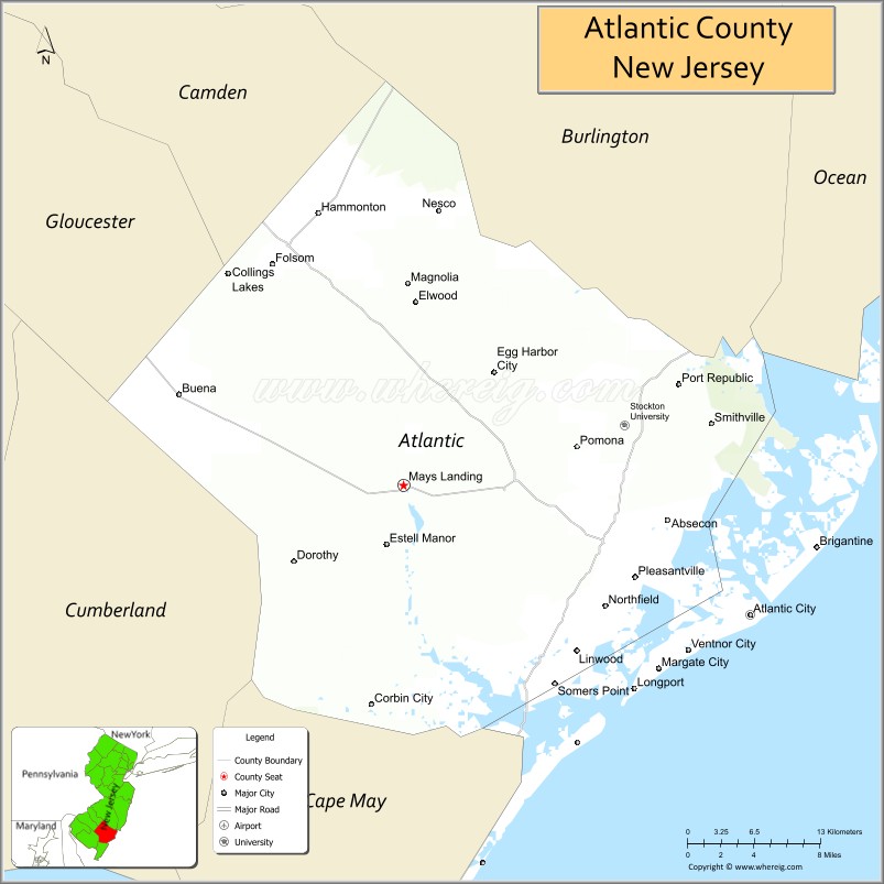
About Atlantic County Map, Alabama: The map showing the county boundary, county seat, major cities, highways, water bodies and neighbouring counties.
Other New Jersey Maps & Info
Map of Atlantic County, New Jersey
Atlantic County is a county located in the U.S. state of New Jersey. It's county seat is Mays Landing. As per 2020 census, the population of Atlantic County is 274966 people and population density is 490.14 square miles. According to the United States Census Bureau, the county has a total area of 561 sq mi (1,453 km2). Atlantic County was established on 1837.p>
Atlantic County Facts
| Continent | North America |
| Country | United States |
| State | New Jersey |
| County Seat | Mays Landing |
| Largest City/Town | Egg Harbor Township |
| Established | 1837 |
| Total Area | 671 sq mi |
| Land Area | 556 sq mi |
| Water Area | 115 sq mi |
| Population | 274,534 (Census 2020) |
| Population Density | 493 people per sq mi |
| Time Zone | Eastern (EST) |
| Major Highways | Atlantic City Expressway, Garden State Parkway, US-30, US-40 |
| Neighboring Counties | Burlington County, Camden County, Gloucester County, Cumberland County, Cape May County |
| Famous For | Atlantic City, beaches, casinos, boardwalk |
| Top Attractions | Atlantic City Boardwalk, Casinos, Absecon Lighthouse |
| Official Website | https://www.atlanticcountynj.gov |
Cities and Towns in Atlantic County, New Jersey
- Mays Landing (county seat) – 2,147 (Census 2020)
- Atlantic City – 38,497 (Census 2020)
- Egg Harbor Township – 47,842 (Census 2020)
- Pleasantville – 20,629 (Census 2020)
Roads and Highways in Atlantic County, New Jersey
Atlantic County has a strong transportation network that connects the Jersey Shore to Philadelphia and other nearby regions.
- Atlantic City Expressway – Main route connecting Atlantic City to Philadelphia
- Garden State Parkway – Runs north-south connecting the county to North and South Jersey
- U.S. Route 30 (US-30) – Connects Atlantic City to Camden and inland areas
- U.S. Route 40 (US-40) – Links the county to Delaware and South Jersey communities
Neighboring Counties of Atlantic County
- Burlington County (north)
- Camden County (northwest)
- Gloucester County (west)
- Cumberland County (southwest)
- Cape May County (south)
Top Attractions in Atlantic County, New Jersey
Atlantic County is best known for its coastal attractions, entertainment, and beach destinations.
- Atlantic City Boardwalk – Famous seaside walkway with shops, restaurants, and entertainment
- Atlantic City Casinos – Major gaming and entertainment venues
- Absecon Lighthouse – Historic lighthouse with views of the city and coast
- Steel Pier – Amusement park with rides and ocean views
- Brigantine Beach – Quiet beach area with scenic coastline
- Lucy the Elephant – Unique roadside attraction in Margate
- Edwin B. Forsythe National Wildlife Refuge – Great for birdwatching and nature exploration
Distance from Atlantic County to Nearby Cities
- Atlantic City to Philadelphia – 60 mi (97 km)
- Atlantic City to New York City – 125 mi (201 km)
- Atlantic City to Trenton – 85 mi (137 km)
- Atlantic City to Newark – 110 mi (177 km)
- Atlantic City to Wilmington – 90 mi (145 km)
FAQs about Atlantic County
Atlantic County is known for Atlantic City, its casinos, beaches, and boardwalk.
Mays Landing is the county seat of Atlantic County.
Egg Harbor Township is the largest municipality by population.
Yes, it includes Atlantic Ocean coastline and popular beach destinations.
It is about 60 miles southeast of Philadelphia.
- Atlantic County Map
- Bergen County Map
- Burlington County Map
- Camden County Map
- Cape May County Map
- Cumberland County Map
- Essex County Map
- Gloucester County Map
- Hudson County Map
- Hunterdon County Map
- Mercer County Map
- Middlesex County Map
- Monmouth County Map
- Morris County Map
- Ocean County Map
- Passaic County Map
- Salem County Map
- Somerset County Map
- Sussex County Map
- Union County Map
- Warren County Map
- Alabama Counties
- Alaska boroughs
- Arizona Counties
- Arkansas Counties
- California County Map
- Colorado Counties
- Connecticut Counties
- Delaware Counties
- Florida County Map
- Georgia County Map
- Hawaii Counties
- Idaho Counties
- Illinois Counties
- Indiana Counties
- Iowa Counties
- Kansas Counties
- Kentucky Counties
- Louisiana Counties
- Maine Counties
- Maryland Counties
- Massachusetts Counties
- Michigan County Map
- Minnesota Counties
- Mississippi Counties
- Missouri Counties
- Montana Counties
- Nebraska Counties
- Nevada Counties
- New York Counties
- New Hampshire Counties
- New Jersey Counties
- New Mexico Counties
- North Carolina Counties
- North Dakota Counties
- Ohio County Map
- Oklahoma Counties
- Oregon Counties
- Pennsylvania Counties
- Rhode Island Counties
- South Carolina Counties
- South Dakota Counties
- Map of Tennessee
- Texas County Map
- Utah Counties
- Vermont Counties
- Virginia Counties
- Washington Counties
- West Virginia Counties
- Wisconsin Counties
- Wyoming Counties