Map of Ocean County - Ocean County is a county located in the U.S. state of New Jersey. Ocean County Map showing cities, highways, important places and water bodies. Get Where is Ocean County located in the map, major cities in Ocean county, population, areas, and places of interest.
Map of Ocean County, New Jersey
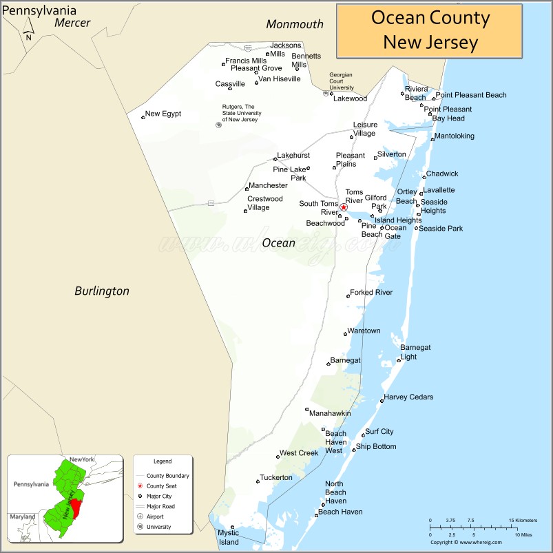
About Ocean County Map, Alabama: The map showing the county boundary, county seat, major cities, highways, water bodies and neighbouring counties.
Other New Jersey Maps & Info
Map of Ocean County, New Jersey
Ocean County is a county located in the U.S. state of New Jersey. It's county seat is Toms River. As per 2020 census, the population of Ocean County is 648998 people and population density is 1020.44 square miles. According to the United States Census Bureau, the county has a total area of 636 sq mi (1,647 km2). Ocean County was established on 1850.
Ocean County Facts
| Continent | North America |
| Country | United States |
| State | New Jersey |
| County Seat | Toms River |
| Largest City/Town | Toms River |
| Established | 1850 |
| Total Area | 916 sq mi |
| Land Area | 628 sq mi |
| Water Area | 288 sq mi |
| Population | 637,229 (Census 2020) |
| Population Density | 1,015 people per sq mi |
| Time Zone | Eastern (EST) |
| Major Highways | Garden State Parkway, I-195, US-9, NJ-37 |
| Neighboring Counties | Monmouth County, Burlington County, Atlantic County |
| Famous For | Jersey Shore beaches, Barnegat Bay, seaside communities |
| Top Attractions | Island Beach State Park, Seaside Heights Boardwalk, Barnegat Lighthouse |
| Official Website | https://www.co.ocean.nj.us |
Cities and Towns in Ocean County, New Jersey
- Toms River (county seat) – 95,438 (Census 2020)
- Lakewood – 135,158 (Census 2020)
- Brick Township – 73,620 (Census 2020)
- Jackson Township – 58,544 (Census 2020)
Roads and Highways in Ocean County, New Jersey
Ocean County is served by major highways that connect coastal communities to inland New Jersey and nearby cities.
- Garden State Parkway – Main north-south route connecting the county to North Jersey and the Jersey Shore
- Interstate 195 (I-195) – Connects the county to Trenton and central New Jersey
- U.S. Route 9 (US-9) – Runs through the county linking local towns and communities
- New Jersey Route 37 (NJ-37) – Connects Toms River to barrier island beaches
Neighboring Counties of Ocean County
- Monmouth County (north)
- Burlington County (west)
- Atlantic County (southwest)
Top Attractions in Ocean County, New Jersey
Ocean County is a popular destination for beaches, boardwalks, and outdoor recreation along the Jersey Shore.
- Island Beach State Park – Natural barrier island with beaches, dunes, and wildlife
- Seaside Heights Boardwalk – Famous for rides, entertainment, and ocean views
- Barnegat Lighthouse – Historic lighthouse with scenic coastal views
- Six Flags Great Adventure (Jackson) – Large amusement park with rides and safari
- Long Beach Island – Popular beach destination with small towns and scenic views
- Barnegat Bay – Ideal for boating, fishing, and water activities
- Cattus Island County Park – Nature preserve with trails and environmental center
Distance from Ocean County to Nearby Cities
- Toms River to New York City – 70 mi (113 km)
- Toms River to Newark – 60 mi (97 km)
- Toms River to Trenton – 45 mi (72 km)
- Toms River to Philadelphia – 65 mi (105 km)
- Toms River to Atlantic City – 60 mi (97 km)
FAQs about Ocean County
Ocean County is known for its Jersey Shore beaches, boardwalks, and coastal communities.
Toms River is the county seat and largest municipality.
Yes, it has extensive coastline along the Atlantic Ocean and Barnegat Bay.
Visitors enjoy beaches, boardwalks, amusement parks, and natural areas.
Yes, it is a major summer tourist destination in New Jersey.
- Atlantic County Map
- Bergen County Map
- Burlington County Map
- Camden County Map
- Cape May County Map
- Cumberland County Map
- Essex County Map
- Gloucester County Map
- Hudson County Map
- Hunterdon County Map
- Mercer County Map
- Middlesex County Map
- Monmouth County Map
- Morris County Map
- Ocean County Map
- Passaic County Map
- Salem County Map
- Somerset County Map
- Sussex County Map
- Union County Map
- Warren County Map
- Alabama Counties
- Alaska boroughs
- Arizona Counties
- Arkansas Counties
- California County Map
- Colorado Counties
- Connecticut Counties
- Delaware Counties
- Florida County Map
- Georgia County Map
- Hawaii Counties
- Idaho Counties
- Illinois Counties
- Indiana Counties
- Iowa Counties
- Kansas Counties
- Kentucky Counties
- Louisiana Counties
- Maine Counties
- Maryland Counties
- Massachusetts Counties
- Michigan County Map
- Minnesota Counties
- Mississippi Counties
- Missouri Counties
- Montana Counties
- Nebraska Counties
- Nevada Counties
- New York Counties
- New Hampshire Counties
- New Jersey Counties
- New Mexico Counties
- North Carolina Counties
- North Dakota Counties
- Ohio County Map
- Oklahoma Counties
- Oregon Counties
- Pennsylvania Counties
- Rhode Island Counties
- South Carolina Counties
- South Dakota Counties
- Map of Tennessee
- Texas County Map
- Utah Counties
- Vermont Counties
- Virginia Counties
- Washington Counties
- West Virginia Counties
- Wisconsin Counties
- Wyoming Counties