Map of Bergen County - Bergen County is a county located in the U.S. state of New Jersey. Bergen County Map showing cities, highways, important places and water bodies. Get Where is Bergen County located in the map, major cities in Bergen county, population, areas, and places of interest.
Map of Bergen County, New Jersey
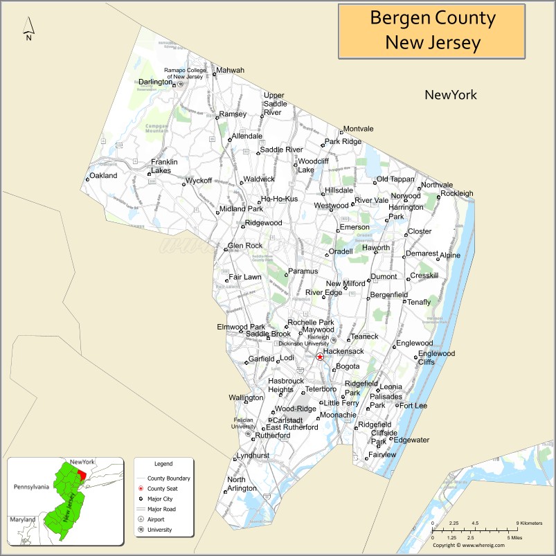
About Bergen County Map, Alabama: The map showing the county boundary, county seat, major cities, highways, water bodies and neighbouring counties.
Other New Jersey Maps & Info
Map of Bergen County, New Jersey
Bergen County is a county located in the U.S. state of New Jersey. It's county seat is Hackensack. As per 2020 census, the population of Bergen County is 953819 people and population density is 4076.15 square miles. According to the United States Census Bureau, the county has a total area of 234 sq mi (606 km2). Bergen County was established on 1683.
Bergen County Facts
| Continent | North America |
| Country | United States |
| State | New Jersey |
| County Seat | Hackensack |
| Largest City/Town | Hackensack |
| Established | 1683 |
| Total Area | 246 sq mi |
| Land Area | 233 sq mi |
| Water Area | 13 sq mi |
| Population | 955,732 (Census 2020) |
| Population Density | 4,100 people per sq mi |
| Time Zone | Eastern (EST) |
| Major Highways | I-95, I-80, Garden State Parkway, NJ Turnpike |
| Neighboring Counties | Hudson County, Passaic County, Essex County, Rockland County (NY) |
| Famous For | Proximity to New York City, shopping centers, suburban communities |
| Top Attractions | American Dream Mall, Bergen County Zoo, Ramapo Mountain State Forest |
| Official Website | https://www.co.bergen.nj.us |
Cities and Towns in Bergen County, New Jersey
- Hackensack (county seat) – 46,030 (Census 2020)
- Fort Lee – 40,191 (Census 2020)
- Teaneck – 41,246 (Census 2020)
- Paramus – 26,342 (Census 2020)
Roads and Highways in Bergen County, New Jersey
Bergen County has a dense highway network that provides direct access to New York City and major regional routes.
- Interstate 95 (I-95) – Major north-south corridor connecting the county to New York City and beyond
- Interstate 80 (I-80) – Runs east-west linking Bergen County to Pennsylvania and New York
- Garden State Parkway – Connects the county to North and South Jersey
- New Jersey Turnpike – Key route for regional travel and commerce
Neighboring Counties of Bergen County
- Hudson County (south)
- Essex County (southwest)
- Passaic County (west)
- Rockland County, NY (north)
Top Attractions in Bergen County, New Jersey
Bergen County offers a mix of shopping, outdoor recreation, and attractions near New York City.
- American Dream Mall – Large shopping and entertainment complex with indoor attractions
- Bergen County Zoo – Family-friendly zoo located in Van Saun Park
- Ramapo Mountain State Forest – Popular for hiking and scenic views
- Overpeck County Park – Offers trails, sports fields, and waterfront views
- New Jersey Naval Museum – Features historic naval vessels
- Fort Lee Historic Park – Site with views of the George Washington Bridge
- Paramus Shopping District – Known for major malls and retail centers
Distance from Bergen County to Nearby Cities
- Hackensack to New York City – 10 mi (16 km)
- Hackensack to Newark – 15 mi (24 km)
- Hackensack to Jersey City – 12 mi (19 km)
- Hackensack to Paterson – 10 mi (16 km)
- Hackensack to Philadelphia – 100 mi (161 km)
FAQs about Bergen County
Bergen County is known for its proximity to New York City, shopping centers, and suburban communities.
Hackensack is the county seat and largest city.
Yes, it is part of the New York City metropolitan area.
Visitors enjoy shopping centers, parks, and attractions like the American Dream Mall.
It is about 10 miles from New York City.
- Atlantic County Map
- Bergen County Map
- Burlington County Map
- Camden County Map
- Cape May County Map
- Cumberland County Map
- Essex County Map
- Gloucester County Map
- Hudson County Map
- Hunterdon County Map
- Mercer County Map
- Middlesex County Map
- Monmouth County Map
- Morris County Map
- Ocean County Map
- Passaic County Map
- Salem County Map
- Somerset County Map
- Sussex County Map
- Union County Map
- Warren County Map
- Alabama Counties
- Alaska boroughs
- Arizona Counties
- Arkansas Counties
- California County Map
- Colorado Counties
- Connecticut Counties
- Delaware Counties
- Florida County Map
- Georgia County Map
- Hawaii Counties
- Idaho Counties
- Illinois Counties
- Indiana Counties
- Iowa Counties
- Kansas Counties
- Kentucky Counties
- Louisiana Counties
- Maine Counties
- Maryland Counties
- Massachusetts Counties
- Michigan County Map
- Minnesota Counties
- Mississippi Counties
- Missouri Counties
- Montana Counties
- Nebraska Counties
- Nevada Counties
- New York Counties
- New Hampshire Counties
- New Jersey Counties
- New Mexico Counties
- North Carolina Counties
- North Dakota Counties
- Ohio County Map
- Oklahoma Counties
- Oregon Counties
- Pennsylvania Counties
- Rhode Island Counties
- South Carolina Counties
- South Dakota Counties
- Map of Tennessee
- Texas County Map
- Utah Counties
- Vermont Counties
- Virginia Counties
- Washington Counties
- West Virginia Counties
- Wisconsin Counties
- Wyoming Counties