Map of Monmouth County - Monmouth County is a county located in the U.S. state of New Jersey. Monmouth County Map showing cities, highways, important places and water bodies. Get Where is Monmouth County located in the map, major cities in Monmouth county, population, areas, and places of interest.
Map of Monmouth County, New Jersey
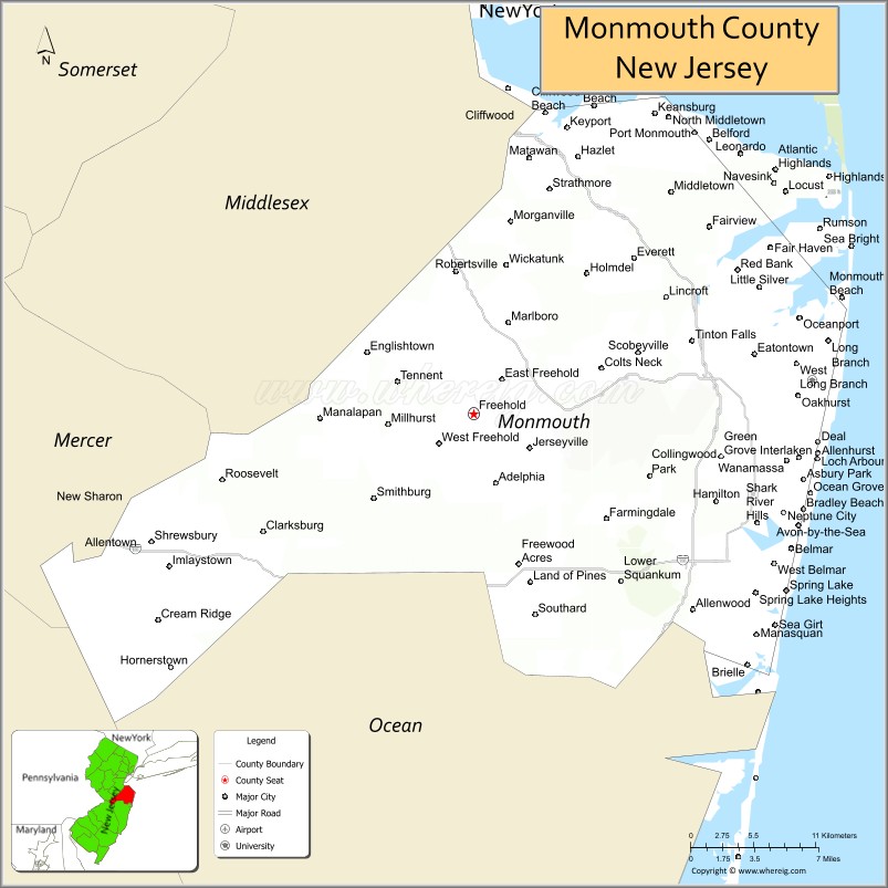
About Monmouth County Map, Alabama: The map showing the county boundary, county seat, major cities, highways, water bodies and neighbouring counties.
Other New Jersey Maps & Info
Map of Monmouth County, New Jersey
Monmouth County is a county located in the U.S. state of New Jersey. It's county seat is Freehold Borough. As per 2020 census, the population of Monmouth County is 645354 people and population density is 1367.28 square miles. According to the United States Census Bureau, the county has a total area of 472 sq mi (1,222 km2). Monmouth County was established on 1683.
Monmouth County Facts
| Continent | North America |
| Country | United States |
| State | New Jersey |
| County Seat | Freehold Borough |
| Largest City/Town | Middletown Township |
| Established | 1683 |
| Total Area | 665 sq mi |
| Land Area | 468 sq mi |
| Water Area | 197 sq mi |
| Population | 643,615 (Census 2020) |
| Population Density | 1,375 people per sq mi |
| Time Zone | Eastern (EST) |
| Major Highways | Garden State Parkway, I-195, NJ-18, NJ-33 |
| Neighboring Counties | Middlesex County, Ocean County, Burlington County, Mercer County |
| Famous For | Jersey Shore beaches, historic sites, coastal communities |
| Top Attractions | Asbury Park Boardwalk, Sandy Hook, Monmouth Battlefield State Park |
| Official Website | https://www.visitmonmouth.com |
Cities and Towns in Monmouth County, New Jersey
- Freehold Borough (county seat) – 12,538 (Census 2020)
- Middletown Township – 67,106 (Census 2020)
- Howell Township – 53,537 (Census 2020)
- Neptune Township – 27,935 (Census 2020)
Roads and Highways in Monmouth County, New Jersey
Monmouth County is served by major highways that connect the Jersey Shore to central New Jersey and nearby cities.
- Garden State Parkway – Main north-south route connecting the county to North and South Jersey
- Interstate 195 (I-195) – Connects the county to Trenton and central New Jersey
- New Jersey Route 18 (NJ-18) – Links coastal areas to inland communities
- New Jersey Route 33 (NJ-33) – Connects Freehold to Trenton and surrounding areas
Neighboring Counties of Monmouth County
- Middlesex County (northwest)
- Ocean County (south)
- Burlington County (southwest)
- Mercer County (west)
Top Attractions in Monmouth County, New Jersey
Monmouth County is a popular destination for beaches, parks, and historic sites along the Jersey Shore.
- Asbury Park Boardwalk – Famous for beaches, music venues, and nightlife
- Sandy Hook – Coastal park with beaches, trails, and lighthouse
- Monmouth Battlefield State Park – Historic Revolutionary War site
- Seven Presidents Oceanfront Park – Beachfront park with recreation areas
- Allaire State Park – Historic village and scenic parkland
- Pier Village (Long Branch) – Shopping, dining, and beachfront views
- Count Basie Center for the Arts – Venue for concerts and performances
Distance from Monmouth County to Nearby Cities
- Freehold to New York City – 50 mi (80 km)
- Freehold to Newark – 45 mi (72 km)
- Freehold to Trenton – 30 mi (48 km)
- Freehold to Philadelphia – 70 mi (113 km)
- Freehold to Atlantic City – 80 mi (129 km)
FAQs about Monmouth County
Monmouth County is known for its Jersey Shore beaches, historic sites, and coastal communities.
Freehold Borough is the county seat of Monmouth County.
Middletown Township is the largest municipality by population.
Yes, it includes several popular beaches along the Atlantic Ocean.
Visitors can enjoy beaches, parks, boardwalks, and historic landmarks.
- Atlantic County Map
- Bergen County Map
- Burlington County Map
- Camden County Map
- Cape May County Map
- Cumberland County Map
- Essex County Map
- Gloucester County Map
- Hudson County Map
- Hunterdon County Map
- Mercer County Map
- Middlesex County Map
- Monmouth County Map
- Morris County Map
- Ocean County Map
- Passaic County Map
- Salem County Map
- Somerset County Map
- Sussex County Map
- Union County Map
- Warren County Map
- Alabama Counties
- Alaska boroughs
- Arizona Counties
- Arkansas Counties
- California County Map
- Colorado Counties
- Connecticut Counties
- Delaware Counties
- Florida County Map
- Georgia County Map
- Hawaii Counties
- Idaho Counties
- Illinois Counties
- Indiana Counties
- Iowa Counties
- Kansas Counties
- Kentucky Counties
- Louisiana Counties
- Maine Counties
- Maryland Counties
- Massachusetts Counties
- Michigan County Map
- Minnesota Counties
- Mississippi Counties
- Missouri Counties
- Montana Counties
- Nebraska Counties
- Nevada Counties
- New York Counties
- New Hampshire Counties
- New Jersey Counties
- New Mexico Counties
- North Carolina Counties
- North Dakota Counties
- Ohio County Map
- Oklahoma Counties
- Oregon Counties
- Pennsylvania Counties
- Rhode Island Counties
- South Carolina Counties
- South Dakota Counties
- Map of Tennessee
- Texas County Map
- Utah Counties
- Vermont Counties
- Virginia Counties
- Washington Counties
- West Virginia Counties
- Wisconsin Counties
- Wyoming Counties