Map of Burlington County - Burlington County is a county located in the U.S. state of New Jersey. Burlington County Map showing cities, highways, important places and water bodies. Get Where is Burlington County located in the map, major cities in Burlington county, population, areas, and places of interest.
Map of Burlington County, New Jersey
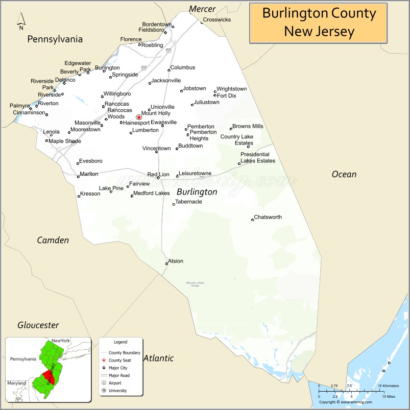
About Burlington County Map, Alabama: The map showing the county boundary, county seat, major cities, highways, water bodies and neighbouring counties.
Other New Jersey Maps & Info
Map of Burlington County, New Jersey
Burlington County is a county located in the U.S. state of New Jersey. It's county seat is Mount Holly. As per 2020 census, the population of Burlington County is 464269 people and population density is 576.73 square miles. According to the United States Census Bureau, the county has a total area of 805 sq mi (2,085 km2). Burlington County was established on 1694.
Burlington County Facts
| Continent | North America |
| Country | United States |
| State | New Jersey |
| County Seat | Mount Holly |
| Largest City/Town | Evesham Township |
| Established | 1694 |
| Total Area | 819 sq mi |
| Land Area | 799 sq mi |
| Water Area | 20 sq mi |
| Population | 461,860 (Census 2020) |
| Population Density | 578 people per sq mi |
| Time Zone | Eastern (EST) |
| Major Highways | I-295, NJ Turnpike, US-130, US-206 |
| Neighboring Counties | Mercer County, Monmouth County, Ocean County, Atlantic County, Camden County |
| Famous For | Pine Barrens, Joint Base McGuire-Dix-Lakehurst, historic towns |
| Top Attractions | Batsto Village, Brendan T. Byrne State Forest, Smithville Park |
| Official Website | https://www.co.burlington.nj.us |
Cities and Towns in Burlington County, New Jersey
- Mount Holly (county seat) – 9,536 (Census 2020)
- Evesham Township – 46,826 (Census 2020)
- Mount Laurel – 44,633 (Census 2020)
- Willingboro – 31,889 (Census 2020)
Roads and Highways in Burlington County, New Jersey
Burlington County has a strong transportation network connecting South Jersey to Philadelphia and the Jersey Shore.
- Interstate 295 (I-295) – Runs north-south connecting the county to Trenton and Delaware
- New Jersey Turnpike – Major toll road linking the county to New York City and Philadelphia
- U.S. Route 130 (US-130) – Connects local communities across the county
- U.S. Route 206 (US-206) – Runs through the county connecting to central New Jersey
Neighboring Counties of Burlington County
- Mercer County (north)
- Monmouth County (northeast)
- Ocean County (east)
- Atlantic County (south)
- Camden County (west)
Top Attractions in Burlington County, New Jersey
Burlington County offers a mix of history, forests, and outdoor recreation across South Jersey.
- Batsto Village – Historic village in the Pine Barrens with preserved buildings
- Brendan T. Byrne State Forest – Large forest area with hiking and camping
- Smithville Park – Popular park with trails, lake views, and picnic areas
- Wharton State Forest (partly) – Largest state forest in New Jersey with outdoor activities
- Historic Smithville Mansion – Historic site with gardens and walking trails
- Rancocas State Park – Offers hiking, biking, and nature programs
- Joint Base McGuire-Dix-Lakehurst – Major military installation (restricted access)
Distance from Burlington County to Nearby Cities
- Mount Holly to Philadelphia – 20 mi (32 km)
- Mount Holly to Trenton – 30 mi (48 km)
- Mount Holly to Atlantic City – 60 mi (97 km)
- Mount Holly to New York City – 80 mi (129 km)
- Mount Holly to Newark – 75 mi (121 km)
FAQs about Burlington County
Burlington County is known for the Pine Barrens, historic villages, and outdoor recreation areas.
Mount Holly is the county seat of Burlington County.
Evesham Township is the largest municipality by population.
Yes, it is located just east of Philadelphia.
Visitors can explore forests, parks, trails, and historic sites throughout the county.
- Atlantic County Map
- Bergen County Map
- Burlington County Map
- Camden County Map
- Cape May County Map
- Cumberland County Map
- Essex County Map
- Gloucester County Map
- Hudson County Map
- Hunterdon County Map
- Mercer County Map
- Middlesex County Map
- Monmouth County Map
- Morris County Map
- Ocean County Map
- Passaic County Map
- Salem County Map
- Somerset County Map
- Sussex County Map
- Union County Map
- Warren County Map
- Alabama Counties
- Alaska boroughs
- Arizona Counties
- Arkansas Counties
- California County Map
- Colorado Counties
- Connecticut Counties
- Delaware Counties
- Florida County Map
- Georgia County Map
- Hawaii Counties
- Idaho Counties
- Illinois Counties
- Indiana Counties
- Iowa Counties
- Kansas Counties
- Kentucky Counties
- Louisiana Counties
- Maine Counties
- Maryland Counties
- Massachusetts Counties
- Michigan County Map
- Minnesota Counties
- Mississippi Counties
- Missouri Counties
- Montana Counties
- Nebraska Counties
- Nevada Counties
- New York Counties
- New Hampshire Counties
- New Jersey Counties
- New Mexico Counties
- North Carolina Counties
- North Dakota Counties
- Ohio County Map
- Oklahoma Counties
- Oregon Counties
- Pennsylvania Counties
- Rhode Island Counties
- South Carolina Counties
- South Dakota Counties
- Map of Tennessee
- Texas County Map
- Utah Counties
- Vermont Counties
- Virginia Counties
- Washington Counties
- West Virginia Counties
- Wisconsin Counties
- Wyoming Counties