Map of Salem County - Salem County is a county located in the U.S. state of New Jersey. Salem County Map showing cities, highways, important places and water bodies. Get Where is Salem County located in the map, major cities in Salem county, population, areas, and places of interest.
Map of Salem County, New Jersey
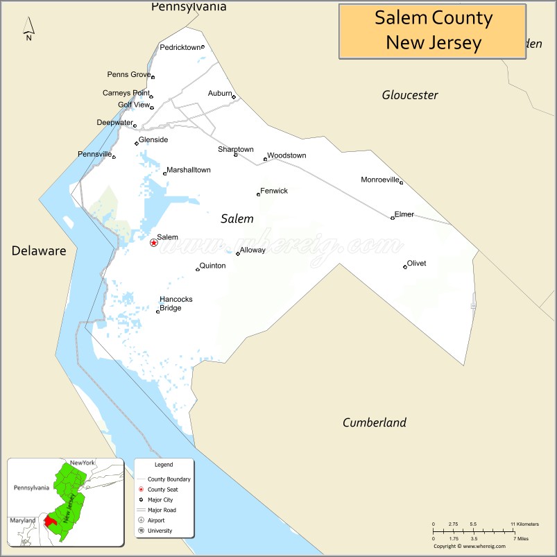
About Salem County Map, Alabama: The map showing the county boundary, county seat, major cities, highways, water bodies and neighbouring counties.
Other New Jersey Maps & Info
Map of Salem County, New Jersey
Salem County is a county located in the U.S. state of New Jersey. It's county seat is Salem. As per 2020 census, the population of Salem County is 65046 people and population density is 193.51 square miles. According to the United States Census Bureau, the county has a total area of 338 sq mi (875 km2). Salem County was established on 1694.
Salem County Facts
| Continent | North America |
| Country | United States |
| State | New Jersey |
| County Seat | Salem |
| Largest City/Town | Pennsville Township |
| Established | 1694 |
| Total Area | 372 sq mi |
| Land Area | 331 sq mi |
| Water Area | 41 sq mi |
| Population | 64,837 (Census 2020) |
| Population Density | 196 people per sq mi |
| Time Zone | Eastern (EST) |
| Major Highways | I-295, NJ Turnpike, US-40, NJ-49 |
| Neighboring Counties | Gloucester County, Cumberland County, New Castle County (DE) |
| Famous For | Delaware River, agriculture, rural landscapes |
| Top Attractions | Fort Mott State Park, Salem River, Supawna Meadows National Wildlife Refuge |
| Official Website | https://www.salemcountynj.gov |
Cities and Towns in Salem County, New Jersey
- Salem (county seat) – 5,296 (Census 2020)
- Pennsville Township – 12,684 (Census 2020)
- Carneys Point Township – 8,049 (Census 2020)
- Woodstown – 3,505 (Census 2020)
Roads and Highways in Salem County, New Jersey
Salem County is connected by several highways that provide access to Delaware and surrounding South Jersey regions.
- Interstate 295 (I-295) – Runs north-south connecting the county to Trenton and Delaware
- New Jersey Turnpike – Major route linking the county to North Jersey and Delaware
- U.S. Route 40 (US-40) – Connects the county to Delaware and Atlantic County
- New Jersey Route 49 (NJ-49) – Runs across the county linking local communities
Neighboring Counties of Salem County
- Gloucester County (north)
- Cumberland County (east)
- New Castle County, DE (west)
Top Attractions in Salem County, New Jersey
Salem County offers a quiet, rural setting with natural areas and historic sites along the Delaware River.
- Fort Mott State Park – Historic Civil War-era fort with river views
- Supawna Meadows National Wildlife Refuge – Great for birdwatching and nature exploration
- Salem River – Scenic river for kayaking and fishing
- Hancock House – Historic site from the Revolutionary War era
- Woodstown Lake – Popular spot for recreation and picnics
- Deepwater Industrial Area – Important regional economic hub
- Finns Point National Cemetery – Historic cemetery and memorial site
Distance from Salem County to Nearby Cities
- Salem to Philadelphia – 35 mi (56 km)
- Salem to Wilmington – 15 mi (24 km)
- Salem to Atlantic City – 70 mi (113 km)
- Salem to Trenton – 60 mi (97 km)
- Salem to New York City – 110 mi (177 km)
FAQs about Salem County
Salem County is known for its rural landscapes, agriculture, and Delaware River views.
Salem is the county seat of Salem County.
Pennsville Township is the largest municipality by population.
Yes, it borders Delaware along the Delaware River.
Visitors can enjoy fishing, kayaking, wildlife viewing, and exploring parks and natural areas.
- Atlantic County Map
- Bergen County Map
- Burlington County Map
- Camden County Map
- Cape May County Map
- Cumberland County Map
- Essex County Map
- Gloucester County Map
- Hudson County Map
- Hunterdon County Map
- Mercer County Map
- Middlesex County Map
- Monmouth County Map
- Morris County Map
- Ocean County Map
- Passaic County Map
- Salem County Map
- Somerset County Map
- Sussex County Map
- Union County Map
- Warren County Map
- Alabama Counties
- Alaska boroughs
- Arizona Counties
- Arkansas Counties
- California County Map
- Colorado Counties
- Connecticut Counties
- Delaware Counties
- Florida County Map
- Georgia County Map
- Hawaii Counties
- Idaho Counties
- Illinois Counties
- Indiana Counties
- Iowa Counties
- Kansas Counties
- Kentucky Counties
- Louisiana Counties
- Maine Counties
- Maryland Counties
- Massachusetts Counties
- Michigan County Map
- Minnesota Counties
- Mississippi Counties
- Missouri Counties
- Montana Counties
- Nebraska Counties
- Nevada Counties
- New York Counties
- New Hampshire Counties
- New Jersey Counties
- New Mexico Counties
- North Carolina Counties
- North Dakota Counties
- Ohio County Map
- Oklahoma Counties
- Oregon Counties
- Pennsylvania Counties
- Rhode Island Counties
- South Carolina Counties
- South Dakota Counties
- Map of Tennessee
- Texas County Map
- Utah Counties
- Vermont Counties
- Virginia Counties
- Washington Counties
- West Virginia Counties
- Wisconsin Counties
- Wyoming Counties