Map of Sussex County - Sussex County is a county located in the U.S. state of New Jersey. Sussex County Map showing cities, highways, important places and water bodies. Get Where is Sussex County located in the map, major cities in Sussex county, population, areas, and places of interest.
Map of Sussex County, New Jersey
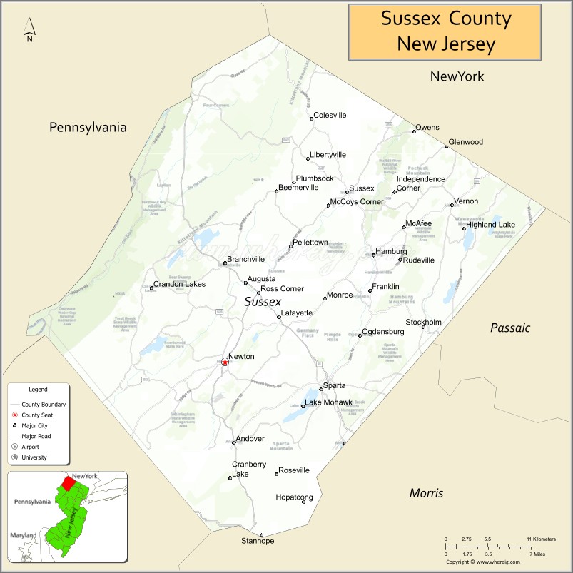
About Sussex County Map, Alabama: The map showing the county boundary, county seat, major cities, highways, water bodies and neighbouring counties.
Other New Jersey Maps & Info
Map of Sussex County, New Jersey
Sussex County is a county located in the U.S. state of New Jersey. It's county seat is Newton. As per 2020 census, the population of Sussex County is 145543 people and population density is 279.35 square miles. According to the United States Census Bureau, the county has a total area of 521 sq mi (1,349 km2). Sussex County was established on 1753.
Sussex County Facts
| Continent | North America |
| Country | United States |
| State | New Jersey |
| County Seat | Newton |
| Largest City/Town | Vernon Township |
| Established | 1753 |
| Total Area | 535 sq mi |
| Land Area | 519 sq mi |
| Water Area | 16 sq mi |
| Population | 144,221 (Census 2020) |
| Population Density | 278 people per sq mi |
| Time Zone | Eastern (EST) |
| Major Highways | US-206, NJ-15, NJ-23, I-80 |
| Neighboring Counties | Warren County, Morris County, Passaic County, Orange County (NY), Pike County (PA) |
| Famous For | Mountains, lakes, outdoor recreation, rural landscapes |
| Top Attractions | High Point State Park, Delaware Water Gap, Mountain Creek Resort |
| Official Website | https://www.sussex.nj.us |
Cities and Towns in Sussex County, New Jersey
- Newton (county seat) – 8,374 (Census 2020)
- Vernon Township – 22,358 (Census 2020)
- Sparta Township – 19,722 (Census 2020)
- Hopatcong – 14,548 (Census 2020)
Roads and Highways in Sussex County, New Jersey
Sussex County is connected by key highways that provide access to North Jersey, Pennsylvania, and New York.
- U.S. Route 206 (US-206) – Runs north-south connecting the county to central New Jersey and Pennsylvania
- New Jersey Route 15 (NJ-15) – Major route linking Sussex County to Morris County
- New Jersey Route 23 (NJ-23) – Connects the county to Passaic County and North Jersey
- Interstate 80 (I-80) – Runs east-west along the southern part of the county connecting to Pennsylvania and New York
Neighboring Counties of Sussex County
- Warren County (southwest)
- Morris County (south)
- Passaic County (east)
- Orange County, NY (north)
- Pike County, PA (west)
Top Attractions in Sussex County, New Jersey
Sussex County is known for its scenic mountains, lakes, and outdoor activities.
- High Point State Park – Home to the highest elevation in New Jersey with scenic views
- Delaware Water Gap – Popular area for hiking, rafting, and outdoor recreation
- Mountain Creek Resort – Ski resort and water park offering year-round activities
- Lake Hopatcong – Largest freshwater lake in New Jersey for boating and fishing
- Stokes State Forest – Offers camping, hiking, and scenic nature areas
- Space Farms Zoo & Museum – Family attraction with animals and exhibits
- Sussex County Fairgrounds – Hosts events, fairs, and agricultural shows
Distance from Sussex County to Nearby Cities
- Newton to New York City – 60 mi (97 km)
- Newton to Newark – 45 mi (72 km)
- Newton to Paterson – 40 mi (64 km)
- Newton to Philadelphia – 90 mi (145 km)
- Newton to Scranton, PA – 70 mi (113 km)
FAQs about Sussex County
Sussex County is known for its mountains, lakes, and outdoor recreation opportunities.
Newton is the county seat of Sussex County.
Vernon Township is the largest municipality by population.
Yes, it is one of the more rural and scenic counties in New Jersey.
Visitors can enjoy hiking, skiing, boating, fishing, and exploring parks and forests.
- Atlantic County Map
- Bergen County Map
- Burlington County Map
- Camden County Map
- Cape May County Map
- Cumberland County Map
- Essex County Map
- Gloucester County Map
- Hudson County Map
- Hunterdon County Map
- Mercer County Map
- Middlesex County Map
- Monmouth County Map
- Morris County Map
- Ocean County Map
- Passaic County Map
- Salem County Map
- Somerset County Map
- Sussex County Map
- Union County Map
- Warren County Map
- Alabama Counties
- Alaska boroughs
- Arizona Counties
- Arkansas Counties
- California County Map
- Colorado Counties
- Connecticut Counties
- Delaware Counties
- Florida County Map
- Georgia County Map
- Hawaii Counties
- Idaho Counties
- Illinois Counties
- Indiana Counties
- Iowa Counties
- Kansas Counties
- Kentucky Counties
- Louisiana Counties
- Maine Counties
- Maryland Counties
- Massachusetts Counties
- Michigan County Map
- Minnesota Counties
- Mississippi Counties
- Missouri Counties
- Montana Counties
- Nebraska Counties
- Nevada Counties
- New York Counties
- New Hampshire Counties
- New Jersey Counties
- New Mexico Counties
- North Carolina Counties
- North Dakota Counties
- Ohio County Map
- Oklahoma Counties
- Oregon Counties
- Pennsylvania Counties
- Rhode Island Counties
- South Carolina Counties
- South Dakota Counties
- Map of Tennessee
- Texas County Map
- Utah Counties
- Vermont Counties
- Virginia Counties
- Washington Counties
- West Virginia Counties
- Wisconsin Counties
- Wyoming Counties