Map of Hunterdon County - Hunterdon County is a county located in the U.S. state of New Jersey. Hunterdon County Map showing cities, highways, important places and water bodies. Get Where is Hunterdon County located in the map, major cities in Hunterdon county, population, areas, and places of interest.
Map of Hunterdon County, New Jersey
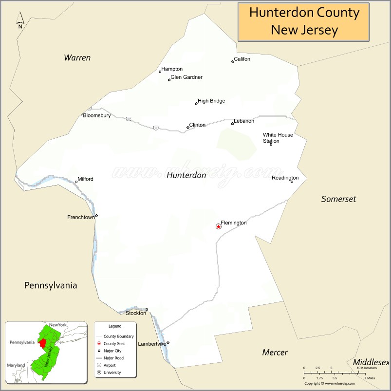
About Hunterdon County Map, Alabama: The map showing the county boundary, county seat, major cities, highways, water bodies and neighbouring counties.
Other New Jersey Maps & Info
Map of Hunterdon County, New Jersey
Hunterdon County is a county located in the U.S. state of New Jersey. It's county seat is Flemington. As per 2020 census, the population of Hunterdon County is 129924 people and population density is 302.15 square miles. According to the United States Census Bureau, the county has a total area of 430 sq mi (1,114 km2). Hunterdon County was established on 1714.
Hunterdon County Facts
| Continent | North America |
| Country | United States |
| State | New Jersey |
| County Seat | Flemington |
| Largest City/Town | Raritan Township |
| Established | 1714 |
| Total Area | 437 sq mi |
| Land Area | 428 sq mi |
| Water Area | 9 sq mi |
| Population | 128,947 (Census 2020) |
| Population Density | 301 people per sq mi |
| Time Zone | Eastern (EST) |
| Major Highways | I-78, US-22, NJ-31, NJ-12 |
| Neighboring Counties | Somerset County, Mercer County, Warren County, Morris County, Bucks County (PA) |
| Famous For | Rural landscapes, Delaware River, historic towns |
| Top Attractions | Delaware River, Round Valley Reservoir, Red Mill Museum Village |
| Official Website | https://www.co.hunterdon.nj.us |
Cities and Towns in Hunterdon County, New Jersey
- Flemington (county seat) – 4,641 (Census 2020)
- Raritan Township – 23,933 (Census 2020)
- Clinton – 2,690 (Census 2020)
- Lambertville – 4,139 (Census 2020)
Roads and Highways in Hunterdon County, New Jersey
Hunterdon County is connected by several highways that provide access to central New Jersey and Pennsylvania.
- Interstate 78 (I-78) – Runs east-west connecting the county to Newark and Pennsylvania
- U.S. Route 22 (US-22) – Connects local communities and links to major regional routes
- New Jersey Route 31 (NJ-31) – Main north-south route through the county
- New Jersey Route 12 (NJ-12) – Connects Flemington to the Delaware River area
Neighboring Counties of Hunterdon County
- Somerset County (east)
- Morris County (northeast)
- Warren County (northwest)
- Mercer County (south)
- Bucks County, PA (west)
Top Attractions in Hunterdon County, New Jersey
Hunterdon County is known for its scenic countryside, river views, and historic charm.
- Delaware River – Popular for kayaking, fishing, and scenic drives
- Round Valley Reservoir – Offers boating, hiking, and camping
- Red Mill Museum Village – Historic site with preserved buildings and exhibits
- Clinton Historic District – Charming area with shops and historic landmarks
- Spruce Run Recreation Area – Large park with lake access and trails
- Lambertville Historic District – Artsy town with galleries and riverfront views
- Hunterdon Art Museum – Cultural center with art exhibits and programs
Distance from Hunterdon County to Nearby Cities
- Flemington to Newark – 45 mi (72 km)
- Flemington to New York City – 65 mi (105 km)
- Flemington to Philadelphia – 55 mi (89 km)
- Flemington to Trenton – 30 mi (48 km)
- Flemington to Allentown, PA – 40 mi (64 km)
FAQs about Hunterdon County
Hunterdon County is known for its rural landscapes, Delaware River views, and historic towns.
Flemington is the county seat of Hunterdon County.
Raritan Township is the largest municipality by population.
Yes, it is one of the more rural and scenic counties in New Jersey.
Visitors can enjoy hiking, boating, fishing, and exploring parks and river areas.
- Atlantic County Map
- Bergen County Map
- Burlington County Map
- Camden County Map
- Cape May County Map
- Cumberland County Map
- Essex County Map
- Gloucester County Map
- Hudson County Map
- Hunterdon County Map
- Mercer County Map
- Middlesex County Map
- Monmouth County Map
- Morris County Map
- Ocean County Map
- Passaic County Map
- Salem County Map
- Somerset County Map
- Sussex County Map
- Union County Map
- Warren County Map
- Alabama Counties
- Alaska boroughs
- Arizona Counties
- Arkansas Counties
- California County Map
- Colorado Counties
- Connecticut Counties
- Delaware Counties
- Florida County Map
- Georgia County Map
- Hawaii Counties
- Idaho Counties
- Illinois Counties
- Indiana Counties
- Iowa Counties
- Kansas Counties
- Kentucky Counties
- Louisiana Counties
- Maine Counties
- Maryland Counties
- Massachusetts Counties
- Michigan County Map
- Minnesota Counties
- Mississippi Counties
- Missouri Counties
- Montana Counties
- Nebraska Counties
- Nevada Counties
- New York Counties
- New Hampshire Counties
- New Jersey Counties
- New Mexico Counties
- North Carolina Counties
- North Dakota Counties
- Ohio County Map
- Oklahoma Counties
- Oregon Counties
- Pennsylvania Counties
- Rhode Island Counties
- South Carolina Counties
- South Dakota Counties
- Map of Tennessee
- Texas County Map
- Utah Counties
- Vermont Counties
- Virginia Counties
- Washington Counties
- West Virginia Counties
- Wisconsin Counties
- Wyoming Counties