Map of Middlesex County - Middlesex County is a county located in the U.S. state of New Jersey. Middlesex County Map showing cities, highways, important places and water bodies. Get Where is Middlesex County located in the map, major cities in Middlesex county, population, areas, and places of interest.
Map of Middlesex County, New Jersey
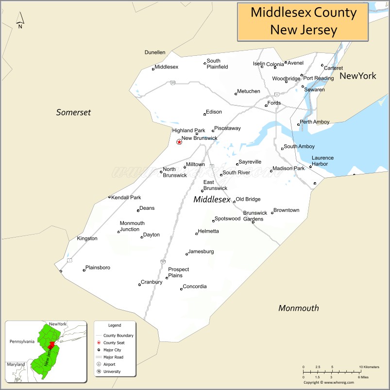
About Middlesex County Map, Alabama: The map showing the county boundary, county seat, major cities, highways, water bodies and neighbouring counties.
Other New Jersey Maps & Info
Map of Middlesex County, New Jersey
Middlesex County is a county located in the U.S. state of New Jersey. It's county seat is New Brunswick. As per 2020 census, the population of Middlesex County is 860807 people and population density is 2767.87 square miles. According to the United States Census Bureau, the county has a total area of 311 sq mi (805 km2). Middlesex County was established on 1683.
Middlesex County Facts
| Continent | North America |
| Country | United States |
| State | New Jersey |
| County Seat | New Brunswick |
| Largest City/Town | Edison |
| Established | 1683 |
| Total Area | 322 sq mi |
| Land Area | 309 sq mi |
| Water Area | 13 sq mi |
| Population | 863,162 (Census 2020) |
| Population Density | 2,790 people per sq mi |
| Time Zone | Eastern (EST) |
| Major Highways | I-95, I-287, US-1, NJ Turnpike, Garden State Parkway |
| Neighboring Counties | Somerset County, Mercer County, Monmouth County, Union County |
| Famous For | Rutgers University, diverse communities, central location |
| Top Attractions | Rutgers University, Thomas Edison Center, Roosevelt Park |
| Official Website | https://www.middlesexcountynj.gov |
Cities and Towns in Middlesex County, New Jersey
- New Brunswick (county seat) – 55,266 (Census 2020)
- Edison – 107,588 (Census 2020)
- Woodbridge Township – 103,639 (Census 2020)
- Piscataway – 60,804 (Census 2020)
Roads and Highways in Middlesex County, New Jersey
Middlesex County is a major transportation hub in central New Jersey with extensive highway access.
- Interstate 95 (I-95) – Part of the New Jersey Turnpike connecting the county to New York and Philadelphia
- Interstate 287 (I-287) – Connects the county to northern and western New Jersey
- U.S. Route 1 (US-1) – Major corridor linking New Brunswick to Trenton and Newark
- Garden State Parkway – Runs north-south connecting the county to other parts of New Jersey
Neighboring Counties of Middlesex County
- Somerset County (northwest)
- Union County (north)
- Monmouth County (east)
- Mercer County (southwest)
Top Attractions in Middlesex County, New Jersey
Middlesex County offers a mix of educational institutions, parks, and cultural attractions.
- Rutgers University – Major public university with historic campus and events
- Thomas Edison Center at Menlo Park – Museum dedicated to the inventor
- Roosevelt Park – Popular park with lake, walking paths, and recreation
- Cheesequake State Park – Unique park with diverse ecosystems and trails
- State Theatre New Jersey – Venue for performances and cultural events
- Johnson Park – Large park with open space, trails, and a small zoo
- Raritan River – Scenic river offering outdoor recreation opportunities
Distance from Middlesex County to Nearby Cities
- New Brunswick to New York City – 40 mi (64 km)
- New Brunswick to Newark – 25 mi (40 km)
- New Brunswick to Trenton – 30 mi (48 km)
- New Brunswick to Philadelphia – 65 mi (105 km)
- New Brunswick to Atlantic City – 90 mi (145 km)
FAQs about Middlesex County
Middlesex County is known for Rutgers University, diverse communities, and its central location.
New Brunswick is the county seat of Middlesex County.
Edison is the largest municipality by population.
Yes, it is located in central New Jersey between New York City and Philadelphia.
Visitors can explore universities, parks, museums, and cultural venues.
- Atlantic County Map
- Bergen County Map
- Burlington County Map
- Camden County Map
- Cape May County Map
- Cumberland County Map
- Essex County Map
- Gloucester County Map
- Hudson County Map
- Hunterdon County Map
- Mercer County Map
- Middlesex County Map
- Monmouth County Map
- Morris County Map
- Ocean County Map
- Passaic County Map
- Salem County Map
- Somerset County Map
- Sussex County Map
- Union County Map
- Warren County Map
- Alabama Counties
- Alaska boroughs
- Arizona Counties
- Arkansas Counties
- California County Map
- Colorado Counties
- Connecticut Counties
- Delaware Counties
- Florida County Map
- Georgia County Map
- Hawaii Counties
- Idaho Counties
- Illinois Counties
- Indiana Counties
- Iowa Counties
- Kansas Counties
- Kentucky Counties
- Louisiana Counties
- Maine Counties
- Maryland Counties
- Massachusetts Counties
- Michigan County Map
- Minnesota Counties
- Mississippi Counties
- Missouri Counties
- Montana Counties
- Nebraska Counties
- Nevada Counties
- New York Counties
- New Hampshire Counties
- New Jersey Counties
- New Mexico Counties
- North Carolina Counties
- North Dakota Counties
- Ohio County Map
- Oklahoma Counties
- Oregon Counties
- Pennsylvania Counties
- Rhode Island Counties
- South Carolina Counties
- South Dakota Counties
- Map of Tennessee
- Texas County Map
- Utah Counties
- Vermont Counties
- Virginia Counties
- Washington Counties
- West Virginia Counties
- Wisconsin Counties
- Wyoming Counties