Map of Cape May County - Cape May County is a county located in the U.S. state of New Jersey. Cape May County Map showing cities, highways, important places and water bodies. Get Where is Cape May County located in the map, major cities in Cape May county, population, areas, and places of interest.
Map of Cape May County, New Jersey
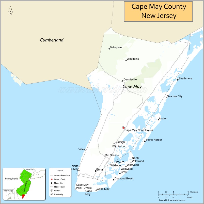
About Cape May County Map, Alabama: The map showing the county boundary, county seat, major cities, highways, water bodies and neighbouring counties.
Other New Jersey Maps & Info
Map of Cape May County, New Jersey
Cape May County is a county located in the U.S. state of New Jersey. It's county seat is Cape May Court House. As per 2020 census, the population of Cape May County is 95661 people and population density is 375.14 square miles. According to the United States Census Bureau, the county has a total area of 255 sq mi (660 km2). Cape May County was established on 1692.
Cape May County Facts
| Continent | North America |
| Country | United States |
| State | New Jersey |
| County Seat | Cape May Court House |
| Largest City/Town | Middle Township |
| Established | 1692 |
| Total Area | 620 sq mi |
| Land Area | 251 sq mi |
| Water Area | 369 sq mi |
| Population | 95,263 (Census 2020) |
| Population Density | 380 people per sq mi |
| Time Zone | Eastern (EST) |
| Major Highways | Garden State Parkway, US-9, NJ-47 |
| Neighboring Counties | Atlantic County, Cumberland County |
| Famous For | Beaches, Cape May, Victorian architecture, tourism |
| Top Attractions | Cape May Historic District, Wildwood Boardwalk, Cape May Lighthouse |
| Official Website | https://capemaycountynj.gov |
Cities and Towns in Cape May County, New Jersey
- Cape May Court House (county seat) – 5,338 (Census 2020)
- Cape May – 2,768 (Census 2020)
- Wildwood – 5,157 (Census 2020)
- Ocean City – 11,229 (Census 2020)
Roads and Highways in Cape May County, New Jersey
Cape May County is connected by major coastal highways that provide access to beach towns and the Jersey Shore.
- Garden State Parkway – Main north-south route connecting the county to Atlantic City and North Jersey
- U.S. Route 9 (US-9) – Runs along the coast connecting local communities
- New Jersey Route 47 (NJ-47) – Connects the county to inland areas and the Delaware Bay region
Neighboring Counties of Cape May County
- Atlantic County (north)
- Cumberland County (west)
Top Attractions in Cape May County, New Jersey
Cape May County is a popular vacation destination known for its beaches, boardwalks, and historic charm.
- Cape May Historic District – Known for Victorian homes and seaside charm
- Wildwood Boardwalk – Famous for amusement rides, shops, and entertainment
- Cape May Lighthouse – Historic lighthouse with panoramic ocean views
- Ocean City Boardwalk – Family-friendly boardwalk with attractions and beaches
- Sunset Beach – Popular spot for watching sunsets and relaxing
- Cape May County Park & Zoo – Free zoo with a wide variety of animals
- Stone Harbor Beach – Quiet beach area with scenic coastline
Distance from Cape May County to Nearby Cities
- Cape May to Atlantic City – 45 mi (72 km)
- Cape May to Philadelphia – 90 mi (145 km)
- Cape May to Wilmington – 85 mi (137 km)
- Cape May to New York City – 150 mi (241 km)
- Cape May to Dover, DE – 70 mi (113 km)
FAQs about Cape May County
Cape May County is known for its beaches, boardwalks, and Victorian architecture.
Cape May Court House is the county seat.
Yes, it is located along the Atlantic Ocean and is a major beach destination.
Visitors enjoy beaches, boardwalks, lighthouses, and historic districts.
Yes, it is one of the most popular vacation destinations in New Jersey.
- Atlantic County Map
- Bergen County Map
- Burlington County Map
- Camden County Map
- Cape May County Map
- Cumberland County Map
- Essex County Map
- Gloucester County Map
- Hudson County Map
- Hunterdon County Map
- Mercer County Map
- Middlesex County Map
- Monmouth County Map
- Morris County Map
- Ocean County Map
- Passaic County Map
- Salem County Map
- Somerset County Map
- Sussex County Map
- Union County Map
- Warren County Map
- Alabama Counties
- Alaska boroughs
- Arizona Counties
- Arkansas Counties
- California County Map
- Colorado Counties
- Connecticut Counties
- Delaware Counties
- Florida County Map
- Georgia County Map
- Hawaii Counties
- Idaho Counties
- Illinois Counties
- Indiana Counties
- Iowa Counties
- Kansas Counties
- Kentucky Counties
- Louisiana Counties
- Maine Counties
- Maryland Counties
- Massachusetts Counties
- Michigan County Map
- Minnesota Counties
- Mississippi Counties
- Missouri Counties
- Montana Counties
- Nebraska Counties
- Nevada Counties
- New York Counties
- New Hampshire Counties
- New Jersey Counties
- New Mexico Counties
- North Carolina Counties
- North Dakota Counties
- Ohio County Map
- Oklahoma Counties
- Oregon Counties
- Pennsylvania Counties
- Rhode Island Counties
- South Carolina Counties
- South Dakota Counties
- Map of Tennessee
- Texas County Map
- Utah Counties
- Vermont Counties
- Virginia Counties
- Washington Counties
- West Virginia Counties
- Wisconsin Counties
- Wyoming Counties