Map of Warren County - Warren County is a county located in the U.S. state of New Jersey. Warren County Map showing cities, highways, important places and water bodies. Get Where is Warren County located in the map, major cities in Warren county, population, areas, and places of interest.
Map of Warren County, New Jersey
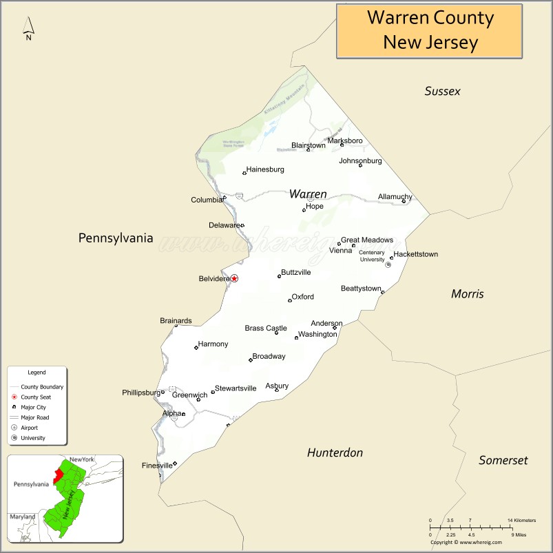
About Warren County Map, Alabama: The map showing the county boundary, county seat, major cities, highways, water bodies and neighbouring counties.
Other New Jersey Maps & Info
Map of Warren County, New Jersey
Warren County is a county located in the U.S. state of New Jersey. It's county seat is Belvidere. As per 2020 census, the population of Warren County is 110731 people and population density is 309.3 square miles. According to the United States Census Bureau, the county has a total area of 358 sq mi (927 km2). Warren County was established on 1824.
Warren County Facts
| Continent | North America |
| Country | United States |
| State | New Jersey |
| County Seat | Belvidere |
| Largest City/Town | Hackettstown |
| Established | 1824 |
| Total Area | 362 sq mi |
| Land Area | 356 sq mi |
| Water Area | 6 sq mi |
| Population | 109,632 (Census 2020) |
| Population Density | 308 people per sq mi |
| Time Zone | Eastern (EST) |
| Major Highways | I-80, US-46, NJ-31, NJ-57 |
| Neighboring Counties | Sussex County, Morris County, Hunterdon County, Northampton County (PA) |
| Famous For | Delaware Water Gap, rural landscapes, outdoor recreation |
| Top Attractions | Delaware Water Gap, Jenny Jump State Forest, Pequest Trout Hatchery |
| Official Website | https://www.co.warren.nj.us |
Cities and Towns in Warren County, New Jersey
- Belvidere (county seat) – 2,645 (Census 2020)
- Hackettstown – 10,248 (Census 2020)
- Phillipsburg – 15,249 (Census 2020)
- Washington Township – 18,067 (Census 2020)
Roads and Highways in Warren County, New Jersey
Warren County is connected by key highways that provide access to Pennsylvania and northern New Jersey.
- Interstate 80 (I-80) – Runs east-west connecting the county to Pennsylvania and New York City
- U.S. Route 46 (US-46) – Connects local communities across northern New Jersey
- New Jersey Route 31 (NJ-31) – Runs north-south linking the county to central New Jersey
- New Jersey Route 57 (NJ-57) – Connects towns across the county and to surrounding areas
Neighboring Counties of Warren County
- Sussex County (north)
- Morris County (east)
- Hunterdon County (south)
- Northampton County, PA (west)
Top Attractions in Warren County, New Jersey
Warren County offers scenic landscapes, outdoor recreation, and access to the Delaware River.
- Delaware Water Gap – Popular area for hiking, rafting, and scenic views
- Jenny Jump State Forest – Forest park with trails, camping, and lake views
- Pequest Trout Hatchery – Educational site with fish hatchery tours
- Allamuchy Mountain State Park – Large park with hiking and biking trails
- Shippen Manor Museum – Historic site with colonial-era exhibits
- Stephens State Park – Offers camping, hiking, and river access
- Merrill Creek Reservoir – Scenic reservoir for fishing and birdwatching
Distance from Warren County to Nearby Cities
- Belvidere to New York City – 70 mi (113 km)
- Belvidere to Newark – 55 mi (89 km)
- Belvidere to Trenton – 55 mi (89 km)
- Belvidere to Philadelphia – 80 mi (129 km)
- Belvidere to Allentown, PA – 20 mi (32 km)
FAQs about Warren County
Warren County is known for its scenic landscapes, Delaware Water Gap, and outdoor recreation.
Belvidere is the county seat of Warren County.
Hackettstown is the largest municipality by population.
Yes, it borders Pennsylvania along the Delaware River.
Visitors can enjoy hiking, fishing, rafting, and exploring parks and forests.
- Atlantic County Map
- Bergen County Map
- Burlington County Map
- Camden County Map
- Cape May County Map
- Cumberland County Map
- Essex County Map
- Gloucester County Map
- Hudson County Map
- Hunterdon County Map
- Mercer County Map
- Middlesex County Map
- Monmouth County Map
- Morris County Map
- Ocean County Map
- Passaic County Map
- Salem County Map
- Somerset County Map
- Sussex County Map
- Union County Map
- Warren County Map
- Alabama Counties
- Alaska boroughs
- Arizona Counties
- Arkansas Counties
- California County Map
- Colorado Counties
- Connecticut Counties
- Delaware Counties
- Florida County Map
- Georgia County Map
- Hawaii Counties
- Idaho Counties
- Illinois Counties
- Indiana Counties
- Iowa Counties
- Kansas Counties
- Kentucky Counties
- Louisiana Counties
- Maine Counties
- Maryland Counties
- Massachusetts Counties
- Michigan County Map
- Minnesota Counties
- Mississippi Counties
- Missouri Counties
- Montana Counties
- Nebraska Counties
- Nevada Counties
- New York Counties
- New Hampshire Counties
- New Jersey Counties
- New Mexico Counties
- North Carolina Counties
- North Dakota Counties
- Ohio County Map
- Oklahoma Counties
- Oregon Counties
- Pennsylvania Counties
- Rhode Island Counties
- South Carolina Counties
- South Dakota Counties
- Map of Tennessee
- Texas County Map
- Utah Counties
- Vermont Counties
- Virginia Counties
- Washington Counties
- West Virginia Counties
- Wisconsin Counties
- Wyoming Counties