Map of Gloucester County - Gloucester County is a county located in the U.S. state of New Jersey. Gloucester County Map showing cities, highways, important places and water bodies. Get Where is Gloucester County located in the map, major cities in Gloucester county, population, areas, and places of interest.
Map of Gloucester County, New Jersey
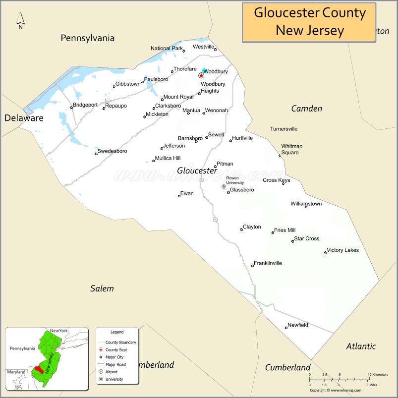
About Gloucester County Map, Alabama: The map showing the county boundary, county seat, major cities, highways, water bodies and neighbouring counties.
Other New Jersey Maps & Info
Map of Gloucester County, New Jersey
Gloucester County is a county located in the U.S. state of New Jersey. It's county seat is Woodbury. As per 2020 census, the population of Gloucester County is 304477 people and population density is 936.85 square miles. According to the United States Census Bureau, the county has a total area of 325 sq mi (842 km2). Gloucester County was established on 1686.
Gloucester County Facts
| Continent | North America |
| Country | United States |
| State | New Jersey |
| County Seat | Woodbury |
| Largest City/Town | Washington Township |
| Established | 1686 |
| Total Area | 337 sq mi |
| Land Area | 322 sq mi |
| Water Area | 15 sq mi |
| Population | 302,294 (Census 2020) |
| Population Density | 939 people per sq mi |
| Time Zone | Eastern (EST) |
| Major Highways | I-295, NJ Turnpike, US-322, US-40 |
| Neighboring Counties | Camden County, Salem County, Atlantic County, Delaware County (PA) |
| Famous For | Suburban communities, agriculture, proximity to Philadelphia |
| Top Attractions | Scotland Run Park, Red Bank Battlefield, Rowan University |
| Official Website | https://www.gloucestercountynj.gov |
Cities and Towns in Gloucester County, New Jersey
- Woodbury (county seat) – 9,963 (Census 2020)
- Washington Township – 48,559 (Census 2020)
- Glassboro – 23,149 (Census 2020)
- Deptford Township – 31,788 (Census 2020)
Roads and Highways in Gloucester County, New Jersey
Gloucester County is well connected with highways that provide easy access to Philadelphia and surrounding South Jersey areas.
- Interstate 295 (I-295) – Runs north-south connecting the county to Trenton and Delaware
- New Jersey Turnpike – Major route linking the county to New York and Philadelphia
- U.S. Route 322 (US-322) – Connects the county to Atlantic City and inland communities
- U.S. Route 40 (US-40) – Runs east-west connecting to Delaware and Atlantic County
Neighboring Counties of Gloucester County
- Camden County (north)
- Atlantic County (east)
- Salem County (southwest)
- Delaware County, PA (west)
Top Attractions in Gloucester County, New Jersey
Gloucester County offers parks, historic sites, and growing suburban attractions near Philadelphia.
- Scotland Run Park – Large park with trails, lake, and recreation areas
- Red Bank Battlefield – Historic Revolutionary War site along the Delaware River
- Rowan University – Major university with cultural and sports events
- James G. Atkinson Park – Popular park with lake views and walking paths
- Heritage Vineyards – Winery offering tastings and scenic views
- Washington Lake Park – Family-friendly park with playgrounds and trails
- Edelman Fossil Park – Unique site where visitors can explore fossils
Distance from Gloucester County to Nearby Cities
- Woodbury to Philadelphia – 10 mi (16 km)
- Woodbury to Atlantic City – 60 mi (97 km)
- Woodbury to Wilmington – 25 mi (40 km)
- Woodbury to Trenton – 50 mi (80 km)
- Woodbury to New York City – 95 mi (153 km)
FAQs about Gloucester County
Gloucester County is known for suburban communities, parks, and its proximity to Philadelphia.
Woodbury is the county seat of Gloucester County.
Washington Township is the largest municipality by population.
Yes, it is located just across the Delaware River from Philadelphia.
Visitors can enjoy parks, lakes, trails, and historic sites throughout the county.
- Atlantic County Map
- Bergen County Map
- Burlington County Map
- Camden County Map
- Cape May County Map
- Cumberland County Map
- Essex County Map
- Gloucester County Map
- Hudson County Map
- Hunterdon County Map
- Mercer County Map
- Middlesex County Map
- Monmouth County Map
- Morris County Map
- Ocean County Map
- Passaic County Map
- Salem County Map
- Somerset County Map
- Sussex County Map
- Union County Map
- Warren County Map
- Alabama Counties
- Alaska boroughs
- Arizona Counties
- Arkansas Counties
- California County Map
- Colorado Counties
- Connecticut Counties
- Delaware Counties
- Florida County Map
- Georgia County Map
- Hawaii Counties
- Idaho Counties
- Illinois Counties
- Indiana Counties
- Iowa Counties
- Kansas Counties
- Kentucky Counties
- Louisiana Counties
- Maine Counties
- Maryland Counties
- Massachusetts Counties
- Michigan County Map
- Minnesota Counties
- Mississippi Counties
- Missouri Counties
- Montana Counties
- Nebraska Counties
- Nevada Counties
- New York Counties
- New Hampshire Counties
- New Jersey Counties
- New Mexico Counties
- North Carolina Counties
- North Dakota Counties
- Ohio County Map
- Oklahoma Counties
- Oregon Counties
- Pennsylvania Counties
- Rhode Island Counties
- South Carolina Counties
- South Dakota Counties
- Map of Tennessee
- Texas County Map
- Utah Counties
- Vermont Counties
- Virginia Counties
- Washington Counties
- West Virginia Counties
- Wisconsin Counties
- Wyoming Counties