Map of Mercer County - Mercer County is a county located in the U.S. state of New Jersey. Mercer County Map showing cities, highways, important places and water bodies. Get Where is Mercer County located in the map, major cities in Mercer county, population, areas, and places of interest.
Map of Mercer County, New Jersey
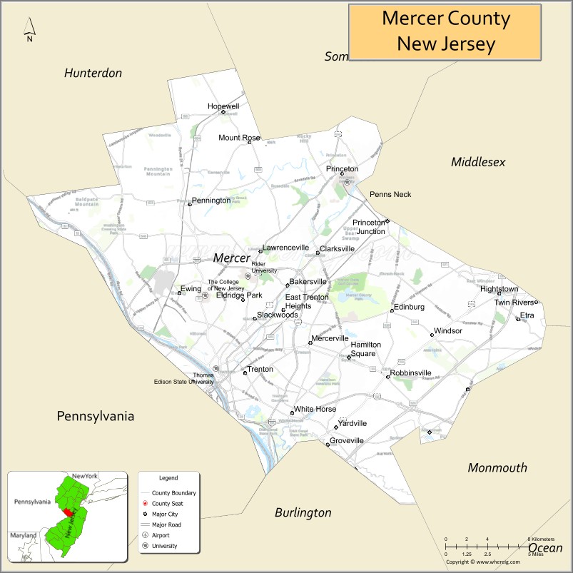
About Mercer County Map, Alabama: The map showing the county boundary, county seat, major cities, highways, water bodies and neighbouring counties.
Other New Jersey Maps & Info
Map of Mercer County, New Jersey
Mercer County is a county located in the U.S. state of New Jersey. It's county seat is Trenton. As per 2020 census, the population of Mercer County is 385898 people and population density is 1707.51 square miles. According to the United States Census Bureau, the county has a total area of 226 sq mi (585 km2). Mercer County was established on 1838.
Mercer County Facts
| Continent | North America |
| Country | United States |
| State | New Jersey |
| County Seat | Trenton |
| Largest City/Town | Hamilton Township |
| Established | 1838 |
| Total Area | 228 sq mi |
| Land Area | 224 sq mi |
| Water Area | 4 sq mi |
| Population | 387,340 (Census 2020) |
| Population Density | 1,730 people per sq mi |
| Time Zone | Eastern (EST) |
| Major Highways | I-95, I-295, US-1, NJ Turnpike |
| Neighboring Counties | Hunterdon County, Somerset County, Middlesex County, Burlington County, Monmouth County, Bucks County (PA) |
| Famous For | State capital Trenton, Princeton University, historical sites |
| Top Attractions | Princeton University, Grounds For Sculpture, New Jersey State House |
| Official Website | https://www.mercercounty.org |
Cities and Towns in Mercer County, New Jersey
- Trenton (county seat) – 90,871 (Census 2020)
- Hamilton Township – 92,297 (Census 2020)
- Princeton – 30,681 (Census 2020)
- Ewing Township – 37,264 (Census 2020)
Roads and Highways in Mercer County, New Jersey
Mercer County is a key transportation hub in central New Jersey with major highways connecting it to New York, Philadelphia, and beyond.
- Interstate 95 (I-95) – Major corridor linking the county to Philadelphia and New York City
- Interstate 295 (I-295) – Runs around Trenton providing access to surrounding areas
- U.S. Route 1 (US-1) – Connects Princeton and Trenton to New Brunswick and Philadelphia
- New Jersey Turnpike – Important route for regional and interstate travel
Neighboring Counties of Mercer County
- Hunterdon County (northwest)
- Somerset County (northeast)
- Middlesex County (east)
- Monmouth County (southeast)
- Burlington County (south)
- Bucks County, PA (west)
Top Attractions in Mercer County, New Jersey
Mercer County offers a blend of history, education, and cultural attractions.
- Princeton University – Prestigious Ivy League campus with historic buildings and museums
- Grounds For Sculpture – Large outdoor sculpture park and museum
- New Jersey State House – Historic government building in Trenton
- Delaware and Raritan Canal State Park – Scenic trails for walking and biking
- Mercer County Park – Large park with lakes, sports fields, and recreation areas
- Old Barracks Museum – Revolutionary War site in Trenton
- Washington Crossing State Park – Historic park marking George Washington’s crossing of the Delaware River
Distance from Mercer County to Nearby Cities
- Trenton to Philadelphia – 30 mi (48 km)
- Trenton to New York City – 60 mi (97 km)
- Trenton to Newark – 50 mi (80 km)
- Trenton to Atlantic City – 60 mi (97 km)
- Trenton to Allentown, PA – 50 mi (80 km)
FAQs about Mercer County
Mercer County is known for Trenton, the state capital, Princeton University, and historic landmarks.
Trenton is the county seat of Mercer County.
Hamilton Township is the largest municipality by population.
Yes, it is located in central New Jersey between New York City and Philadelphia.
Visitors can explore universities, parks, museums, and historic sites.
- Atlantic County Map
- Bergen County Map
- Burlington County Map
- Camden County Map
- Cape May County Map
- Cumberland County Map
- Essex County Map
- Gloucester County Map
- Hudson County Map
- Hunterdon County Map
- Mercer County Map
- Middlesex County Map
- Monmouth County Map
- Morris County Map
- Ocean County Map
- Passaic County Map
- Salem County Map
- Somerset County Map
- Sussex County Map
- Union County Map
- Warren County Map
- Alabama Counties
- Alaska boroughs
- Arizona Counties
- Arkansas Counties
- California County Map
- Colorado Counties
- Connecticut Counties
- Delaware Counties
- Florida County Map
- Georgia County Map
- Hawaii Counties
- Idaho Counties
- Illinois Counties
- Indiana Counties
- Iowa Counties
- Kansas Counties
- Kentucky Counties
- Louisiana Counties
- Maine Counties
- Maryland Counties
- Massachusetts Counties
- Michigan County Map
- Minnesota Counties
- Mississippi Counties
- Missouri Counties
- Montana Counties
- Nebraska Counties
- Nevada Counties
- New York Counties
- New Hampshire Counties
- New Jersey Counties
- New Mexico Counties
- North Carolina Counties
- North Dakota Counties
- Ohio County Map
- Oklahoma Counties
- Oregon Counties
- Pennsylvania Counties
- Rhode Island Counties
- South Carolina Counties
- South Dakota Counties
- Map of Tennessee
- Texas County Map
- Utah Counties
- Vermont Counties
- Virginia Counties
- Washington Counties
- West Virginia Counties
- Wisconsin Counties
- Wyoming Counties