Map of Essex County - Essex County is a county located in the U.S. state of New Jersey. Essex County Map showing cities, highways, important places and water bodies. Get Where is Essex County located in the map, major cities in Essex county, population, areas, and places of interest.
Map of Essex County, New Jersey
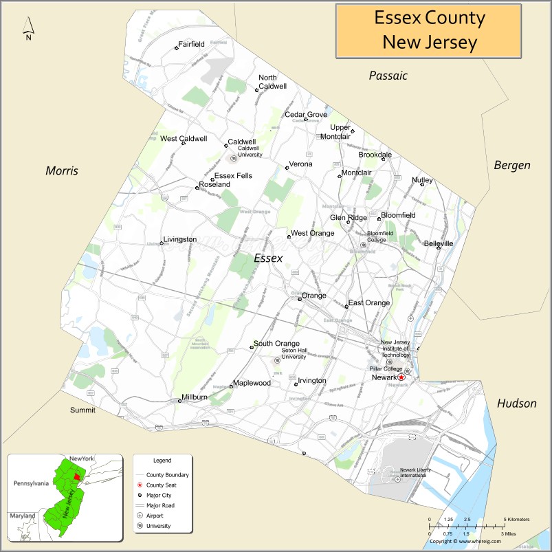
About Essex County Map, Alabama: The map showing the county boundary, county seat, major cities, highways, water bodies and neighbouring counties.
Other New Jersey Maps & Info
Map of Essex County, New Jersey
Essex County is a county located in the U.S. state of New Jersey. It's county seat is Newark. As per 2020 census, the population of Essex County is 854917 people and population density is 6785.06 square miles. According to the United States Census Bureau, the county has a total area of 126 sq mi (326 km2). Essex County was established on 1683.
Essex County Facts
| Continent | North America |
| Country | United States |
| State | New Jersey |
| County Seat | Newark |
| Largest City/Town | Newark |
| Established | 1683 |
| Total Area | 129 sq mi |
| Land Area | 126 sq mi |
| Water Area | 3 sq mi |
| Population | 863,728 (Census 2020) |
| Population Density | 6,850 people per sq mi |
| Time Zone | Eastern (EST) |
| Major Highways | I-95, I-78, Garden State Parkway, NJ Turnpike |
| Neighboring Counties | Hudson County, Bergen County, Passaic County, Morris County, Union County |
| Famous For | Newark, cultural institutions, major transportation hub |
| Top Attractions | Branch Brook Park, Newark Museum of Art, Turtle Back Zoo |
| Official Website | https://essexcountynj.org |
Cities and Towns in Essex County, New Jersey
- Newark (county seat) – 311,549 (Census 2020)
- East Orange – 69,612 (Census 2020)
- Irvington – 61,176 (Census 2020)
- Bloomfield – 53,105 (Census 2020)
Roads and Highways in Essex County, New Jersey
Essex County is a major transportation hub with highways connecting it to New York City and surrounding regions.
- Interstate 95 (I-95) – Major corridor connecting the county to New York City and the East Coast
- Interstate 78 (I-78) – Runs east-west linking Newark to Pennsylvania and New York
- Garden State Parkway – Connects the county to North and South Jersey
- New Jersey Turnpike – Key route for regional and interstate travel
Neighboring Counties of Essex County
- Hudson County (east)
- Bergen County (northeast)
- Passaic County (north)
- Morris County (west)
- Union County (south)
Top Attractions in Essex County, New Jersey
Essex County offers a mix of urban attractions, parks, and cultural institutions.
- Branch Brook Park – Known for its cherry blossom trees and scenic trails
- Newark Museum of Art – Largest museum in New Jersey with diverse exhibits
- Turtle Back Zoo – Family-friendly zoo with a wide range of animals
- South Mountain Reservation – Large nature area with hiking trails and waterfalls
- Prudential Center – Major arena hosting sports and concerts
- Thomas Edison National Historical Park – Historic site dedicated to the inventor
- Military Park – Historic park in downtown Newark
Distance from Essex County to Nearby Cities
- Newark to New York City – 10 mi (16 km)
- Newark to Jersey City – 8 mi (13 km)
- Newark to Paterson – 15 mi (24 km)
- Newark to Trenton – 55 mi (89 km)
- Newark to Philadelphia – 85 mi (137 km)
FAQs about Essex County
Essex County is known for Newark, cultural institutions, and its role as a transportation hub.
Newark is the county seat and largest city.
Yes, it is part of the New York City metropolitan area.
Visitors enjoy parks, museums, zoos, and cultural venues.
It is about 10 miles from New York City.
- Atlantic County Map
- Bergen County Map
- Burlington County Map
- Camden County Map
- Cape May County Map
- Cumberland County Map
- Essex County Map
- Gloucester County Map
- Hudson County Map
- Hunterdon County Map
- Mercer County Map
- Middlesex County Map
- Monmouth County Map
- Morris County Map
- Ocean County Map
- Passaic County Map
- Salem County Map
- Somerset County Map
- Sussex County Map
- Union County Map
- Warren County Map
- Alabama Counties
- Alaska boroughs
- Arizona Counties
- Arkansas Counties
- California County Map
- Colorado Counties
- Connecticut Counties
- Delaware Counties
- Florida County Map
- Georgia County Map
- Hawaii Counties
- Idaho Counties
- Illinois Counties
- Indiana Counties
- Iowa Counties
- Kansas Counties
- Kentucky Counties
- Louisiana Counties
- Maine Counties
- Maryland Counties
- Massachusetts Counties
- Michigan County Map
- Minnesota Counties
- Mississippi Counties
- Missouri Counties
- Montana Counties
- Nebraska Counties
- Nevada Counties
- New York Counties
- New Hampshire Counties
- New Jersey Counties
- New Mexico Counties
- North Carolina Counties
- North Dakota Counties
- Ohio County Map
- Oklahoma Counties
- Oregon Counties
- Pennsylvania Counties
- Rhode Island Counties
- South Carolina Counties
- South Dakota Counties
- Map of Tennessee
- Texas County Map
- Utah Counties
- Vermont Counties
- Virginia Counties
- Washington Counties
- West Virginia Counties
- Wisconsin Counties
- Wyoming Counties