Map of Hudson County - Hudson County is a county located in the U.S. state of New Jersey. Hudson County Map showing cities, highways, important places and water bodies. Get Where is Hudson County located in the map, major cities in Hudson county, population, areas, and places of interest.
Map of Hudson County, New Jersey
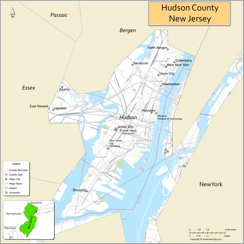
About Hudson County Map, Alabama: The map showing the county boundary, county seat, major cities, highways, water bodies and neighbouring counties.
Other New Jersey Maps & Info
Map of Hudson County, New Jersey
Hudson County is a county located in the U.S. state of New Jersey. It's county seat is Jersey City. As per 2020 census, the population of Hudson County is 702463 people and population density is 14946.02 square miles. According to the United States Census Bureau, the county has a total area of 47 sq mi (122 km2). Hudson County was established on 1840.
Hudson County Facts
| Continent | North America |
| Country | United States |
| State | New Jersey |
| County Seat | Jersey City |
| Largest City/Town | Jersey City |
| Established | 1840 |
| Total Area | 62 sq mi |
| Land Area | 46 sq mi |
| Water Area | 16 sq mi |
| Population | 724,854 (Census 2020) |
| Population Density | 15,758 people per sq mi |
| Time Zone | Eastern (EST) |
| Major Highways | I-78, US-1/9, NJ-440, NJ Turnpike |
| Neighboring Counties | Bergen County, Essex County, Union County |
| Famous For | Proximity to New York City, skyline views, Ellis Island |
| Top Attractions | Liberty State Park, Ellis Island, Hudson River Waterfront |
| Official Website | https://www.hcnj.us |
Cities and Towns in Hudson County, New Jersey
- Jersey City (county seat) – 292,449 (Census 2020)
- Hoboken – 60,419 (Census 2020)
- Union City – 68,589 (Census 2020)
- Bayonne – 71,686 (Census 2020)
Roads and Highways in Hudson County, New Jersey
Hudson County is a major transportation hub with direct connections to New York City and regional highways.
- Interstate 78 (I-78) – Connects Jersey City to Newark and Pennsylvania
- U.S. Route 1/9 (US-1/9) – Runs through the county linking it to North Jersey and New York
- New Jersey Route 440 (NJ-440) – Connects Bayonne and Jersey City to Staten Island
- New Jersey Turnpike – Major corridor for regional travel and commerce
Neighboring Counties of Hudson County
- Bergen County (north)
- Essex County (west)
- Union County (southwest)
Top Attractions in Hudson County, New Jersey
Hudson County offers urban attractions, waterfront views, and historic sites near New York City.
- Liberty State Park – Scenic park with views of the Statue of Liberty and Manhattan skyline
- Ellis Island – Historic immigration site and museum
- Hudson River Waterfront Walkway – Popular path with skyline views
- Hoboken Waterfront – Area with parks, restaurants, and city views
- Liberty Science Center – Interactive science museum for all ages
- Colgate Clock – Iconic landmark on the Jersey City waterfront
- Empty Sky Memorial – 9/11 memorial with views of Lower Manhattan
Distance from Hudson County to Nearby Cities
- Jersey City to New York City – 2 mi (3 km)
- Jersey City to Newark – 10 mi (16 km)
- Jersey City to Paterson – 20 mi (32 km)
- Jersey City to Trenton – 60 mi (97 km)
- Jersey City to Philadelphia – 90 mi (145 km)
FAQs about Hudson County
Hudson County is known for its proximity to New York City, waterfront views, and historic sites like Ellis Island.
Jersey City is the county seat and largest city.
Yes, it is part of the New York City metropolitan area.
Visitors enjoy parks, waterfront views, museums, and historic landmarks.
It is directly across the Hudson River, just a few miles away.
- Atlantic County Map
- Bergen County Map
- Burlington County Map
- Camden County Map
- Cape May County Map
- Cumberland County Map
- Essex County Map
- Gloucester County Map
- Hudson County Map
- Hunterdon County Map
- Mercer County Map
- Middlesex County Map
- Monmouth County Map
- Morris County Map
- Ocean County Map
- Passaic County Map
- Salem County Map
- Somerset County Map
- Sussex County Map
- Union County Map
- Warren County Map
- Alabama Counties
- Alaska boroughs
- Arizona Counties
- Arkansas Counties
- California County Map
- Colorado Counties
- Connecticut Counties
- Delaware Counties
- Florida County Map
- Georgia County Map
- Hawaii Counties
- Idaho Counties
- Illinois Counties
- Indiana Counties
- Iowa Counties
- Kansas Counties
- Kentucky Counties
- Louisiana Counties
- Maine Counties
- Maryland Counties
- Massachusetts Counties
- Michigan County Map
- Minnesota Counties
- Mississippi Counties
- Missouri Counties
- Montana Counties
- Nebraska Counties
- Nevada Counties
- New York Counties
- New Hampshire Counties
- New Jersey Counties
- New Mexico Counties
- North Carolina Counties
- North Dakota Counties
- Ohio County Map
- Oklahoma Counties
- Oregon Counties
- Pennsylvania Counties
- Rhode Island Counties
- South Carolina Counties
- South Dakota Counties
- Map of Tennessee
- Texas County Map
- Utah Counties
- Vermont Counties
- Virginia Counties
- Washington Counties
- West Virginia Counties
- Wisconsin Counties
- Wyoming Counties