Map of Cumberland County - Cumberland County is a county located in the U.S. state of New Jersey. Cumberland County Map showing cities, highways, important places and water bodies. Get Where is Cumberland County located in the map, major cities in Cumberland county, population, areas, and places of interest.
Map of Cumberland County, New Jersey
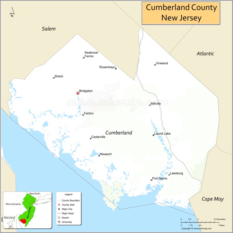
About Cumberland County Map, Alabama: The map showing the county boundary, county seat, major cities, highways, water bodies and neighbouring counties.
Other New Jersey Maps & Info
Map of Cumberland County, New Jersey
Cumberland County is a county located in the U.S. state of New Jersey. It's county seat is Bridgeton. As per 2020 census, the population of Cumberland County is 153627 people and population density is 314.17 square miles. According to the United States Census Bureau, the county has a total area of 489 sq mi (1,267 km2). Cumberland County was established on 1748.
Cumberland County Facts
| Continent | North America |
| Country | United States |
| State | New Jersey |
| County Seat | Bridgeton |
| Largest City/Town | Vineland |
| Established | 1748 |
| Total Area | 677 sq mi |
| Land Area | 484 sq mi |
| Water Area | 193 sq mi |
| Population | 154,152 (Census 2020) |
| Population Density | 318 people per sq mi |
| Time Zone | Eastern (EST) |
| Major Highways | NJ-55, US-40, NJ-47, NJ-49 |
| Neighboring Counties | Gloucester County, Salem County, Atlantic County, Cape May County |
| Famous For | Agriculture, Delaware Bay, glass industry |
| Top Attractions | WheatonArts, Bridgeton City Park, Maurice River |
| Official Website | https://www.cumberlandcountynj.gov |
Cities and Towns in Cumberland County, New Jersey
- Bridgeton (county seat) – 25,349 (Census 2020)
- Vineland – 60,780 (Census 2020)
- Millville – 27,491 (Census 2020)
- Commercial Township – 5,178 (Census 2020)
Roads and Highways in Cumberland County, New Jersey
Cumberland County is connected by several highways that provide access across South Jersey and to the Delaware Bay region.
- New Jersey Route 55 (NJ-55) – Major north-south route connecting the county to Gloucester County and Philadelphia area
- U.S. Route 40 (US-40) – Runs east-west connecting the county to Atlantic City and Delaware
- New Jersey Route 47 (NJ-47) – Connects local communities and links to Cape May County
- New Jersey Route 49 (NJ-49) – Runs across the county connecting to Salem County
Neighboring Counties of Cumberland County
- Gloucester County (north)
- Salem County (west)
- Atlantic County (east)
- Cape May County (south)
Top Attractions in Cumberland County, New Jersey
Cumberland County offers a mix of cultural sites, parks, and scenic natural areas.
- WheatonArts – Cultural center with glassmaking exhibits and arts programs
- Bridgeton City Park – Large historic park with trails, zoo, and lake
- Maurice River – Scenic river popular for kayaking and wildlife viewing
- East Point Lighthouse – Historic lighthouse along the Delaware Bay
- Cohanzick Zoo – Free zoo located in Bridgeton City Park
- Union Lake – Popular spot for fishing, boating, and picnicking
- Millville Army Air Field Museum – Museum focused on World War II aviation history
Distance from Cumberland County to Nearby Cities
- Vineland to Philadelphia – 40 mi (64 km)
- Vineland to Atlantic City – 40 mi (64 km)
- Vineland to Wilmington – 45 mi (72 km)
- Vineland to Trenton – 70 mi (113 km)
- Vineland to New York City – 120 mi (193 km)
FAQs about Cumberland County
Cumberland County is known for agriculture, glassmaking history, and scenic river landscapes.
Bridgeton is the county seat of Cumberland County.
Vineland is the largest city in the county.
It borders the Delaware Bay but is not directly on the Atlantic Ocean.
Visitors can enjoy parks, rivers, boating, fishing, and wildlife observation.
- Atlantic County Map
- Bergen County Map
- Burlington County Map
- Camden County Map
- Cape May County Map
- Cumberland County Map
- Essex County Map
- Gloucester County Map
- Hudson County Map
- Hunterdon County Map
- Mercer County Map
- Middlesex County Map
- Monmouth County Map
- Morris County Map
- Ocean County Map
- Passaic County Map
- Salem County Map
- Somerset County Map
- Sussex County Map
- Union County Map
- Warren County Map
- Alabama Counties
- Alaska boroughs
- Arizona Counties
- Arkansas Counties
- California County Map
- Colorado Counties
- Connecticut Counties
- Delaware Counties
- Florida County Map
- Georgia County Map
- Hawaii Counties
- Idaho Counties
- Illinois Counties
- Indiana Counties
- Iowa Counties
- Kansas Counties
- Kentucky Counties
- Louisiana Counties
- Maine Counties
- Maryland Counties
- Massachusetts Counties
- Michigan County Map
- Minnesota Counties
- Mississippi Counties
- Missouri Counties
- Montana Counties
- Nebraska Counties
- Nevada Counties
- New York Counties
- New Hampshire Counties
- New Jersey Counties
- New Mexico Counties
- North Carolina Counties
- North Dakota Counties
- Ohio County Map
- Oklahoma Counties
- Oregon Counties
- Pennsylvania Counties
- Rhode Island Counties
- South Carolina Counties
- South Dakota Counties
- Map of Tennessee
- Texas County Map
- Utah Counties
- Vermont Counties
- Virginia Counties
- Washington Counties
- West Virginia Counties
- Wisconsin Counties
- Wyoming Counties